
Kentucky Could See First Realistic Severe Weather Chance in Months Next Saturday as Powerful Cold Front and Strong Upper Level Energy Target the Lower Ohio Valley
LOUISVILLE, Kentucky — After a prolonged stretch of quiet and dry weather, Kentucky and the lower Ohio Valley are being closely watched for what could be the first realistic severe weather opportunity in a while — as a powerful atmospheric setup is taking shape for Saturday, April 19, featuring a strong cold front, an explosively deepening upper-level trough, and the critical question of whether enough moisture and instability will be in place across the Bluegrass State to support significant storm development.
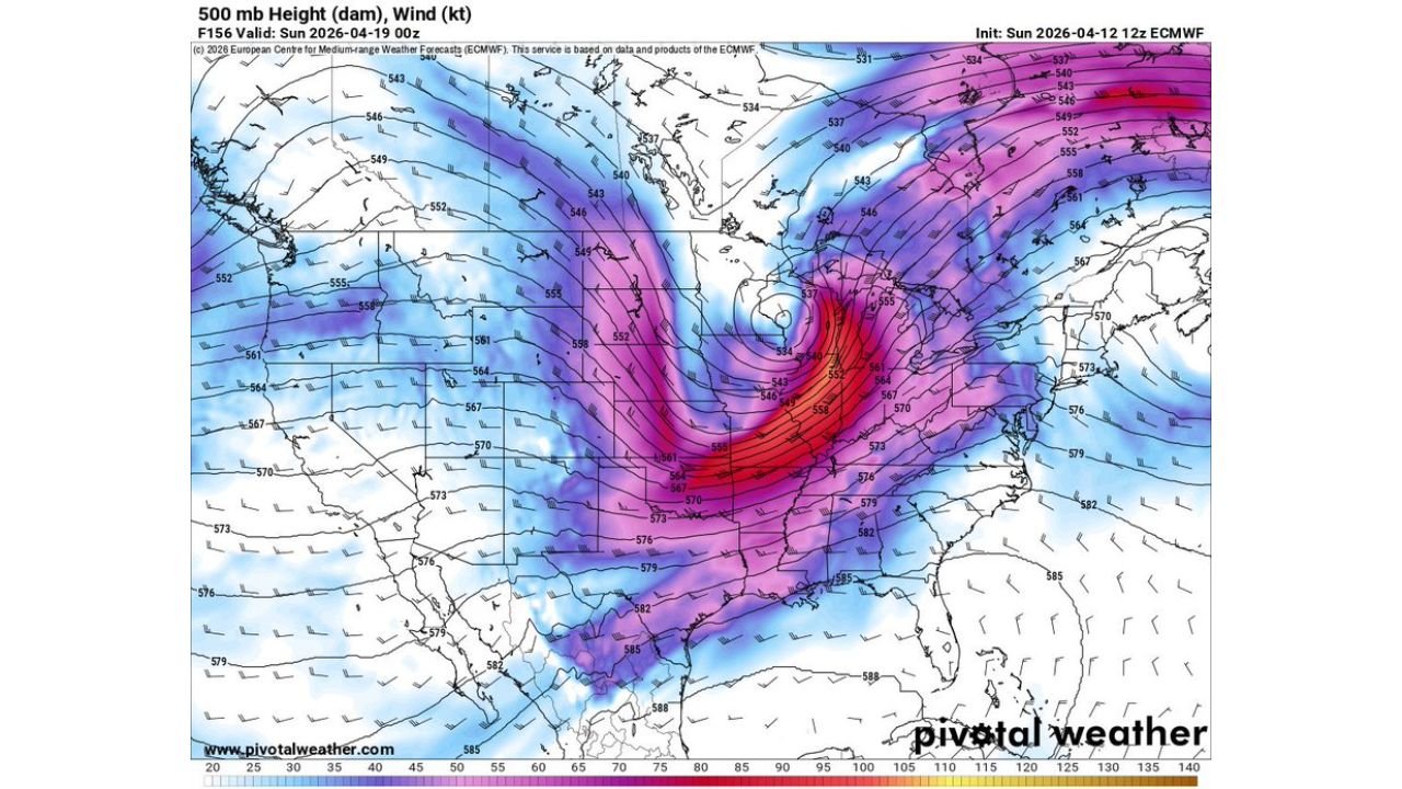
The upper-level pattern valid Sunday, April 19 at 00z — which corresponds to Saturday evening — shows one of the most striking and tightly wound atmospheric configurations seen this spring, with an extremely deep trough digging into the central United States and jet stream winds screaming into the red and purple range directly over the Ohio Valley. The ingredients for severe weather are organizing — but timing and moisture will determine exactly how significant Saturday’s threat becomes for Kentucky and surrounding communities.
Why Saturday Is on the Radar for Kentucky
Three separate atmospheric datasets all point to the same conclusion — Saturday, April 19 deserves serious attention across the lower Ohio Valley:
A Violent Upper-Level Trough: The 500mb height and wind map for Saturday evening is alarming in its intensity. A massively amplified upper-level trough is digging deep into the central United States with wind speeds at altitude reaching 105 to 125+ knots — shown in the deep red and purple shading — right over the Ohio Valley and Kentucky corridor. Tightly packed height contours wrapping around the base of this trough indicate an exceptionally strong and well-organized upper-level system. This is the kind of large-scale atmospheric forcing that takes a loaded surface environment and turns it into an explosive severe weather outbreak. When upper-level winds this strong are positioned directly overhead, any storm that develops beneath them will be immediately operating in a high-shear environment favorable for supercells and tornadoes.
Moisture — The Critical Variable: The 2-meter dewpoint map for Saturday evening shows a sharp and well-defined moisture boundary cutting through the Ohio Valley region. Dewpoints in the upper 50s to low 60s°F are present across Kentucky and the lower Ohio Valley — shown in the green shading extending into the region from the south. These are not exceptional moisture values, but they are sufficient to support storm development if the cold front arrives during peak daytime heating. The key watchpoint forecasters have identified is whether dewpoints and CAPE values can build enough before the cold front sweeps through — this moisture question will be the single biggest factor determining how severe Saturday’s weather becomes across Kentucky.
Active Cold Front Precipitation: The precipitation rate and type map for Saturday evening shows an active line of showers and thunderstorms pushing through the Kentucky and lower Ohio Valley corridor associated with the approaching cold front. Orange and yellow precipitation cores on this map — indicating heavy rainfall rates — are visible across portions of central and southern Kentucky with the storm line oriented from southwest to northeast along the frontal boundary. The precipitation structure shows a classic cold front convective line — the type of setup that can produce damaging winds, hail, and tornadoes when sufficient moisture and instability are present ahead of it.
What Makes This Kentucky’s First Realistic Severe Weather Chance in a While
Kentucky has been largely bypassed by the active severe weather pattern that has been targeting the central Plains, Midwest, and Upper Midwest throughout the first half of April 2026. While states like Nebraska, Kansas, Minnesota, and Missouri have been dealing with repeated tornado threats and significant severe weather outbreaks, Kentucky and the lower Ohio Valley have sat under a dry and warm pattern that has kept severe weather at bay.
Saturday’s setup breaks that pattern — and it does so with significant upper-level energy that gives this event genuine severe weather potential rather than just a typical spring rain event. The combination of a violently deepening upper trough, jet stream winds over 100 knots at altitude, a sharp cold front, and sufficient low-level moisture across Kentucky creates an environment where severe thunderstorm development is not just possible but plausible — provided timing cooperates.
The timing of cold front arrival relative to peak afternoon heating is the most critical uncertainty. If the front pushes through Kentucky during peak instability hours in the mid-afternoon, the severe weather potential increases dramatically. If the front arrives after dark when surface heating has diminished, the overall threat decreases — though nighttime severe weather events along strong cold fronts are never zero-risk situations.
Lower Ohio Valley Communities to Watch
- Kentucky: Louisville, Lexington, Bowling Green, Owensboro, Paducah, and the broader Bluegrass State are all within the Saturday severe weather window as the cold front tracks northeast through the state
- Southern Indiana: Evansville and surrounding southern Indiana communities sit on the northern edge of the lower Ohio Valley threat corridor
- Tennessee: Nashville and northern Tennessee communities may be impacted by the southern end of Saturday’s frontal system depending on moisture return
- Illinois: Southern Illinois communities along the Ohio River corridor fall within the broader Saturday threat area
Two Things Forecasters Are Watching Most Closely
Dewpoints and CAPE Values — The moisture and instability question is explicitly identified as the most important variable for Saturday’s Kentucky severe weather potential. If Gulf moisture can surge further north and dewpoints can climb into the mid-60s across central Kentucky before cold front arrival, the instability available for storm development increases substantially and the severe weather threat escalates. If moisture remains limited, storms will be less organized and the threat remains marginal.
Timing of Cold Front Arrival — A cold front arriving in Kentucky at 2 PM to 5 PM local time would be the worst-case scenario from a severe weather perspective — coinciding with peak afternoon heating and maximum instability. A front arriving after 8 PM would find a more stable atmosphere and produce a less severe outcome. The exact front timing will sharpen considerably as Saturday approaches and higher-resolution forecast data becomes available.
What Kentucky Residents Should Do This Week
- Monitor NWS Louisville and NWS Paducah daily forecast discussions through the week — by Wednesday and Thursday the timing and moisture questions for Saturday will be significantly clearer
- Watch for SPC Day 4 and Day 3 outlooks to begin placing Kentucky within a formal severe weather risk area as Saturday approaches — any upgrade to Slight Risk or higher should be taken seriously
- Saturday afternoon outdoor plans across Kentucky should be treated as tentative until the cold front timing and moisture questions are resolved later this week
- Residents across Louisville, Lexington, Bowling Green, and Paducah should have weather alert systems confirmed and ready before Saturday morning
- The upper-level trough intensity shown in the data is exceptional — if moisture cooperates, this has the potential to be a significant severe weather day for Kentucky regardless of how quiet the state has been recently
Kentucky has been waiting for its turn in this active spring pattern — and Saturday, April 19 may finally deliver it. The upper-level energy is there, the cold front is coming, and the only remaining question is whether the atmosphere over the Bluegrass State will be loaded enough to turn this powerful setup into the first significant severe weather event Kentucky has seen in quite some time.
WaldronNews.com will continue tracking Saturday’s developing severe weather potential across Kentucky and the lower Ohio Valley and will provide updates as moisture, timing, and instability questions become clearer through the week.