
Level 3 Enhanced Risk Confirmed for Minneapolis Monday as Baseball Sized Hail, Damaging Winds and Strong Tornadoes After Dark Threaten Minnesota, Wisconsin and Michigan
MINNEAPOLIS, Minnesota — Monday, April 13 is getting more serious by the hour across the Upper Midwest — a Level 3 out of 5 Enhanced Risk severe weather outlook is now confirmed for the Minneapolis corridor with the threat expanding across Minnesota, Wisconsin, and Michigan as storms hold off until late in the day before firing with explosive intensity — bringing baseball-sized hail, damaging winds, and a few tornadoes including potentially strong ones near the warm front into some of the most populated communities in the Upper Midwest.
The danger window arrives after dark — making this one of the most challenging severe weather scenarios for residents across the region, when visibility is zero, outdoor warning sirens may not be heard indoors, and millions of people may already be asleep when the most dangerous storms arrive.
Risk Levels Across the Threat Zone
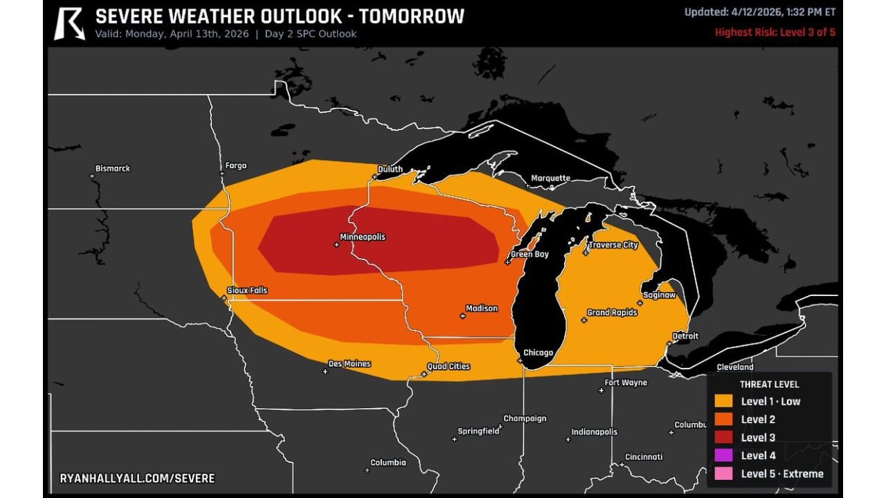
The Day 2 SPC Outlook valid Monday, April 13 shows a clearly defined and escalating risk structure across the Upper Midwest:
- Level 3 — Enhanced Risk (Dark Red Core): Minneapolis and the immediate surrounding metro area sit inside the highest risk designation on Monday’s outlook — the bullseye of the entire event
- Level 2 — Moderate Threat (Orange): Fargo, Duluth, Sioux Falls, Green Bay, Traverse City, Madison, Quad Cities, Des Moines, and Chicago all fall within the broad orange threat corridor
- Level 1 — Low Threat (Outer Orange): Marquette, Saginaw, Grand Rapids, Detroit, Fort Wayne, and the broader Great Lakes fringe communities are within the outer threat zone
- Not in threat zone: Cleveland, Indianapolis, Columbus, and Cincinnati sit just outside Monday’s outlined risk area
Three Threats — All Arriving After Dark
The timing of Monday’s storms is the most dangerous element of this entire setup. Storms are expected to hold off until late in the day — building through the afternoon and erupting with full severity during the evening and overnight hours across Minnesota, Wisconsin, and Michigan. That means the worst conditions will arrive when most residents are winding down for the night or already asleep.
Baseball-Sized Hail: The atmospheric environment Monday is specifically loaded for large hail production — dry air at the mid-levels of the atmosphere allows supercooled water droplets to accumulate aggressively on growing hailstones, while temperatures drop rapidly with altitude to keep those stones frozen until they fall. Baseball-sized hail — approximately 2.75 inches in diameter — falling after dark is extraordinarily dangerous because residents cannot see it coming, have less time to move vehicles to shelter, and may be caught completely off guard by the intensity and suddenness of the hail shaft. A single baseball-sized hailstone carries enough force to shatter windshields, punch holes in roofing, and cause serious injury.
Strong Tornadoes Near the Warm Front: Tornadoes are explicitly on the table Monday — and the most dangerous ones will be those that develop near the warm front where low-level helicity values are highest. When a supercell latches onto a warm front boundary and absorbs the concentrated atmospheric spin available near that boundary, it can produce long-track, violent tornadoes that are significantly more dangerous than typical brief spin-ups. The after dark timing of this tornado threat is the most alarming aspect — nighttime tornadoes are statistically far deadlier than daytime ones because residents have reduced warning time, less visual confirmation, and are more likely to be asleep when warnings are issued.
Damaging Winds: Any storm that develops Monday evening will also carry the threat of straight-line damaging winds capable of downing trees, snapping power lines, and causing widespread property damage across the affected corridor.
Why Minneapolis Is the Bullseye
The Level 3 Enhanced Risk designation centered directly on Minneapolis is not a coincidence — the Twin Cities metro sits at the exact intersection of the warm front position, the highest moisture values, and the strongest atmospheric instability for Monday’s event. This is where the atmosphere is most favorable for the development of organized, long-lived supercells capable of all hazards simultaneously.
Minneapolis residents face a particularly serious situation Monday because:
The after-dark storm window means evening outdoor events, concerts, sporting activities, and commutes could all be interrupted suddenly and violently. The city’s urban environment — with tall buildings, underground parking, and dense residential neighborhoods — creates both shelter opportunities and vulnerabilities depending on where residents are when storms strike.
Vehicle protection is urgent — baseball-sized hail in an urban environment like Minneapolis will cause catastrophic and widespread vehicle damage across the metro. Every vehicle in the Minneapolis metro should be inside a garage or covered structure before Monday evening arrives.
Cities That Must Be On Full Alert Monday Evening
- Minnesota: Minneapolis, St. Paul, Duluth, Fargo, Sioux Falls — Level 3 and Level 2 zones
- Wisconsin: Green Bay, Madison, and the Quad Cities corridor — Level 2 zone
- Michigan: Traverse City, Saginaw, and Grand Rapids — Level 1 to Level 2 boundary zone
- Iowa: Des Moines and the Quad Cities — Level 2 outer zone
- Illinois: Chicago sits on the southern edge of Monday’s threat corridor
What to Do Before Monday Evening
- Secure all vehicles now — every car, truck, and motorcycle in the Minneapolis metro and surrounding Minnesota communities needs to be under cover before Monday evening. Do not wait until storms are forming to move vehicles
- Set overnight weather alerts — since the worst storms arrive after dark, every resident in the Level 3 and Level 2 zones must ensure phone weather alerts are set to override Do Not Disturb mode and sound at full volume even while sleeping
- Know your overnight shelter location — identify the lowest interior room of your home away from windows right now, before Monday evening arrives, so you are not searching for shelter in the dark during a tornado warning
- The warm front position will determine exactly where the strongest tornadoes track Monday night — this is the single most uncertain element and will sharpen through Monday morning
- Families with children across Minneapolis, Green Bay, and the broader threat zone should have a shelter plan that their children know and can execute if parents are not immediately available
- Monitor NWS Twin Cities 5 AM Monday morning update — this will be the most critical forecast discussion of the event and will provide the sharpest available guidance on storm timing and tornado threat corridors
Monday evening is coming fast across the Upper Midwest — and the storms that arrive after dark over Minneapolis, Wisconsin, and Michigan will be carrying baseball-sized hail, damaging winds, and tornadoes that residents cannot afford to be caught unprepared for.
WaldronNews.com will continue tracking Monday’s Level 3 Enhanced Risk severe weather outbreak across Minnesota, Wisconsin, and Michigan and will provide updates through the evening as storms develop and warnings are issued.