
Maryland, Virginia, and Pennsylvania Face Frost and Freeze Risk Tonight as Apparent Temperatures Drop to the 20s and 30s North and West of Interstate 95 Before Near-80 Degree Warmth Returns Next Week
BALTIMORE, Maryland — Areas north and west of Interstate 95 in Maryland are heading into a frost and freeze risk tonight as apparent temperatures drop into the 30s by early Sunday morning, with some western Maryland locations seeing readings in the upper 20s on the forecast map. The cold bite tonight is a short-term event, not a sign of things to come. Temperatures recover toward near 80 degrees for several days next week before a cooler-than-normal pattern returns heading into mid-May. Tonight requires action from gardeners and anyone with cold-sensitive plants, but the broader May warmth window arrives quickly after Sunday’s cold morning passes.
Where Frost and Freeze Conditions Are Most Likely Tonight
The apparent temperature map valid 10AM Sunday May 3 shows the coldest readings concentrated in western Maryland, the Virginia mountains, and rural Pennsylvania, with a clear warmer buffer along the coast and Chesapeake Bay.
| Location | Apparent Temperature Sunday Morning | Frost or Freeze Risk |
|---|---|---|
| Western Maryland mountains | 20 to 24°F | Hard freeze — very high risk |
| Frederick and western Maryland | 25 to 29°F | Freeze risk, plant damage likely |
| Hagerstown area | 29 to 32°F | Freeze borderline |
| Northern Virginia mountains | 24 to 28°F | Hard freeze — very high risk |
| Northern Virginia suburban | 29 to 35°F | Frost to light freeze possible |
| Baltimore suburbs north and west | 33 to 37°F | Frost possible in low-lying areas |
| Baltimore city and east | 37 to 41°F | Frost unlikely, cool morning |
| Annapolis and Bay area | 39 to 45°F | No frost concern |
| Eastern Shore of Maryland | 36 to 42°F | Minimal frost risk |
| Delaware coast | 38 to 42°F | Minimal frost risk |
| Southern Maryland coast | 44 to 48°F | No concern |
The 20 to 24 degree apparent temperatures in western Maryland and the Virginia mountain counties represent genuine hard freeze conditions capable of damaging or killing any plants left unprotected outdoors tonight.
What the I-95 Line Means for Tonight’s Risk
The forecast specifically calls out north and west of Interstate 95 as the frost and freeze zone for tonight. That corridor is a meaningful geographic dividing line for this event.
| West of I-95 | East of I-95 |
|---|---|
| Cold, dry air dominates | Warmer, more moist air from the Chesapeake moderates temperatures |
| Rural terrain with open fields — cold air pools in valleys | Urban heat island in Baltimore and Washington adds several degrees |
| Elevation increases cold exposure in mountain counties | Sea breeze and bay influence keeps coastal areas above frost threshold |
| Apparent temperatures 20s to mid-30s | Apparent temperatures mid-30s to mid-40s |
The Chesapeake Bay acts as a thermal buffer on the eastern side of the I-95 line, releasing stored heat that keeps temperatures several degrees warmer than the rural western counties overnight. This is why Annapolis at the bay sits near 46 degrees while Frederick and Hagerstown approach freezing.
🌡️ Tonight Into Next Week — The Full Pattern Laid Out
| Date | Expected Conditions | Temperature Range |
|---|---|---|
| Tonight Saturday May 2 | Frost and freeze risk north and west of I-95 | Apparent temps 20s to 30s in the cold zone |
| Sunday May 3 | Cold morning, gradual recovery | Morning lows 30s to 40s, afternoon improving |
| Monday through Wednesday | Warm pattern builds | Near 80 degrees for several days |
| Mid-May | Cooler-than-normal pattern returns | Below normal temperatures return to the region |
The near-80 degree warmth arriving Monday through Wednesday offers a genuine brief summer preview before the larger pattern shown on the upper air map reasserts itself in mid-May.
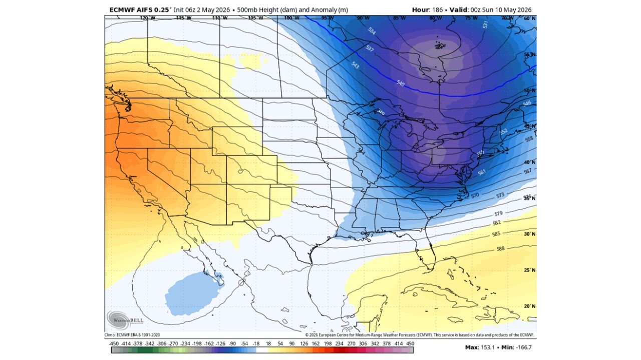
What the Upper Air Pattern Shows for Mid-May
The 500 millibar height map valid Sunday May 10 shows a deep blue and purple trough dominating the entire eastern half of the United States, with height values of 540 to 552 decameters across the Great Lakes, Ohio Valley, and Northeast. This is a significantly below-normal upper air pattern for mid-May.
| Upper Air Feature | What It Means at the Surface |
|---|---|
| Deep blue trough over the East | Cold air locked over the region, temperatures running well below normal |
| Height values 540 to 552 dam | Mid-May values more consistent with late March or early April climatologically |
| Western ridge in orange and yellow | Warm pattern continues in the West while the East stays cool |
| Tight gradient between East and West | Active storm track possible along the boundary, potential for more unsettled weather |
The return of the cooler-than-normal pattern by mid-May means the brief warmth next week is a window, not a season change. Anyone planning outdoor projects or garden work should prioritize the Monday through Wednesday warm window before the pattern flips cold again.
What Maryland, Virginia, and Pennsylvania Residents Must Do Before Tonight
- North and west of I-95 in Maryland covers communities from Frederick and Hagerstown through the mountain counties where apparent temperatures drop into the 20s tonight. Any plants left outdoors in these areas face legitimate freeze damage.
- Cover established garden plants before sunset tonight using frost cloth, old bedsheets, or burlap. The cover traps ground heat and can keep temperatures several degrees warmer underneath, protecting cold-sensitive plants from freeze damage.
- Bring potted plants indoors completely. Container plants lose heat faster than in-ground plants and will freeze at apparent temperatures in the upper 20s without protection.
- Northern Virginia suburban residents west of I-95 in areas like Loudoun and Fauquier counties face borderline freeze conditions. Even if actual air temperature stays just above 32 degrees, frost can form on exposed surfaces when apparent temperatures dip into the upper 20s.
- Baltimore and Washington D.C. residents east of I-95 face a cool but generally frost-safe morning. The bay and urban heat island provide enough thermal buffering to keep overnight lows above the frost threshold for most of the metro area.
- Plan outdoor projects and planting for next week’s warm window from Monday through Wednesday before the cooler-than-normal mid-May pattern arrives. That three-day window near 80 degrees is the best outdoor weather opportunity available for at least two weeks.
WaldronNews.com will continue tracking overnight frost and freeze conditions across Maryland, Virginia, and Pennsylvania and provide updates on next week’s warmup and the mid-May pattern change as forecasts sharpen.