
North Carolina and South Carolina See Morning Mist and Drizzle Saturday With Coastal Areas Picking Up Over 1 Inch While Charlotte Gets 0.31 and Western Mountains Stay Nearly Dry
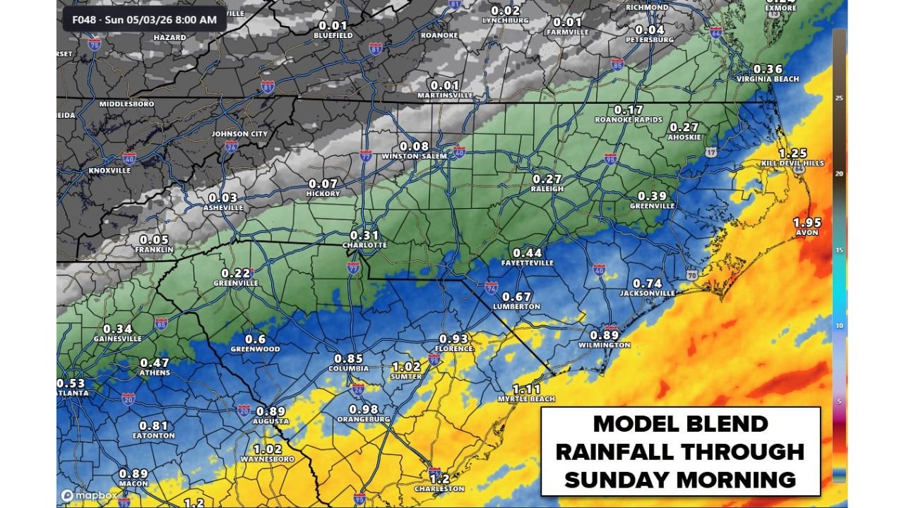
CHARLOTTE, North Carolina — Saturday’s rain event across the Carolinas is trending lighter and more coastal than earlier forecasts suggested, with the rainfall gradient telling a clear story from west to east. Charlotte picks up 0.31 inches, western North Carolina communities like Asheville and Hickory come in at 0.03 to 0.07 inches, and the coast near Avon and Kill Devil Hills reaches 1.25 to 1.95 inches as the low pressure system keeps the heaviest rain locked tightly along the shoreline. The morning will be mainly misty and drizzly with chilly temperatures across the Piedmont and mountains, with the best and only meaningful rains staying closer to the coast throughout the day.
Exact Rainfall Totals Across North Carolina and South Carolina Through Sunday Morning
| City | State | Rainfall Through Sunday 8AM |
|---|---|---|
| Avon | North Carolina | 1.95 inches |
| Kill Devil Hills | North Carolina | 1.25 inches |
| Jacksonville | North Carolina | 0.74 inches |
| Wilmington | North Carolina | 0.89 inches |
| Greenville | North Carolina | 0.39 inches |
| Roanoke Rapids | North Carolina | 0.17 inches |
| Ahoskie | North Carolina | 0.27 inches |
| Fayetteville | North Carolina | 0.44 inches |
| Lumberton | North Carolina | 0.67 inches |
| Laurinburg | North Carolina | 0.60 inches |
| Rockingham | North Carolina | 0.47 inches |
| Pinehurst | North Carolina | 0.44 inches |
| Sanford | North Carolina | 0.39 inches |
| Raleigh | North Carolina | 0.27 inches |
| Durham | North Carolina | 0.24 inches |
| Fuquay-Varina | North Carolina | 0.31 inches |
| Dunn | North Carolina | 0.42 inches |
| Asheboro | North Carolina | 0.36 inches |
| Greensboro | North Carolina | 0.15 inches |
| Winston-Salem | North Carolina | 0.08 inches |
| Salisbury | North Carolina | 0.17 inches |
| Concord | North Carolina | 0.24 inches |
| Charlotte | North Carolina | 0.31 inches |
| Gastonia | North Carolina | 0.17 inches |
| Rock Hill | South Carolina | 0.42 inches |
| Albemarle | North Carolina | 0.47 inches |
| Troy | North Carolina | 0.39 inches |
| Hickory | North Carolina | 0.07 inches |
| Statesville | North Carolina | 0.08 inches |
| Shelby | North Carolina | 0.17 inches |
| Lenoir | North Carolina | 0.06 inches |
| Asheville | North Carolina | 0.03 inches |
| Morganton | North Carolina | 0.07 inches |
| Boone | North Carolina | 0.03 inches |
| Hendersonville | North Carolina | 0.08 inches |
| Myrtle Beach | South Carolina | 1.11 inches |
| Florence | South Carolina | 0.93 inches |
| Marion | South Carolina | 1.11 inches |
| Charleston | South Carolina | 1.20 inches |
| Sumter | South Carolina | 1.02 inches |
| Columbia | South Carolina | 0.85 inches |
| Orangeburg | South Carolina | 0.98 inches |
| Waynesboro | South Carolina | 1.02 inches |
| Greenwood | South Carolina | 0.60 inches |
| Spartanburg | South Carolina | 0.20 inches |
| Greenville | South Carolina | 0.22 inches |
| Augusta | Georgia | 0.89 inches |
| Atlanta | Georgia | 0.53 inches |
The West to East Rainfall Gradient in Plain Terms
The rainfall map draws one of the most dramatic west-to-east gradients visible in a coastal low event across the Carolinas.
| Region | Range | What Saturday Feels Like |
|---|---|---|
| Western North Carolina mountains | 0.03 to 0.08 inches | Nearly dry, overcast and chilly, barely qualifies as drizzle |
| Foothills and western Piedmont | 0.07 to 0.20 inches | Light mist, gray skies, chilly temperatures |
| Charlotte metro | 0.17 to 0.31 inches | Light rain mainly morning, misty and drizzly |
| Central Piedmont and Triad | 0.08 to 0.27 inches | Light rain, not a soaking event |
| Eastern Piedmont and Sandhills | 0.27 to 0.67 inches | Steadier rain, more meaningful accumulation |
| Coastal plain | 0.67 to 1.25 inches | Real rain day, over an inch in places |
| Outer Banks and immediate coast | 1.25 to 1.95 inches | Heaviest totals, genuine soaking event |
The system’s low pressure center hugging the coast is the entire explanation for this gradient. As discussed earlier in the week, when a coastal low stays offshore, it keeps its heaviest rainfall locked near the shoreline rather than pushing meaningful moisture far inland.
🌧️ What Charlotte and the Piedmont Actually Experiences Saturday
| Detail | Charlotte Saturday |
|---|---|
| Total rainfall | 0.31 inches |
| Timing | Mainly morning hours |
| Character | Misty, drizzly, not steady heavy rain |
| Temperature | Chilly, well below normal for early May |
| Sky condition | Gray and overcast all day |
| Afternoon | Drier but still overcast and cool |
| Best description | A raw, gray, damp May Saturday indoors |
Charlotte at 0.31 inches gets a light but real rain event, concentrated in the morning before activity tapers through the afternoon. Anyone hoping for meaningful drought relief from this event will be disappointed. The city has been running well below normal rainfall for weeks and 0.31 inches barely registers against that deficit.
Where the Real Rain Falls This Weekend
The communities that actually see meaningful Saturday rain are located along the South Carolina coastal plain and the North Carolina coast.
| City | Rainfall | Significance |
|---|---|---|
| Avon, North Carolina | 1.95 inches | Heaviest total in the entire two-state region |
| Charleston, South Carolina | 1.20 inches | Over an inch, genuine soaking day |
| Marion, South Carolina | 1.11 inches | Over an inch |
| Myrtle Beach, South Carolina | 1.11 inches | Over an inch for the Grand Strand |
| Sumter, South Carolina | 1.02 inches | Just over an inch |
| Waynesboro, South Carolina | 1.02 inches | Just over an inch |
| Florence, South Carolina | 0.93 inches | Meaningful accumulation |
For the South Carolina coastal communities that have also been running dry in recent months, a 1 to 1.2 inch event provides at least partial drought relief even if it does not fully close the rainfall deficit.
What to Watch Through the Weekend
- Western North Carolina communities from Asheville through Boone and Hickory should not expect any meaningful rain Saturday. The 0.03 to 0.07 inch totals are essentially overcast sky days with no real rainfall benefit.
- Charlotte area outdoor events in the morning face misty and drizzly conditions. The afternoon is drier but still gray and chilly, with temperatures running well below normal for early May making the whole day feel more like March.
- Fayetteville and Lumberton in the southeastern Piedmont see noticeably more rain than Charlotte at 0.44 to 0.67 inches, sitting close enough to the coastal moisture feed to benefit from heavier banding.
- Myrtle Beach and the Grand Strand can plan on a genuine rainy Saturday with over an inch expected. Beach activities and outdoor events along the coast are washed out for the day.
- Sunday clearing timeline across the Carolinas improves as the coastal low tracks northeast and the rain shield moves away from the region, setting up a drier start to the week ahead.
WaldronNews.com will continue tracking the coastal low rainfall event across North Carolina and South Carolina and provide updates on clearing timing and final rainfall totals through Sunday morning.