
North Carolina and South Carolina See Cold Front Arrive by 5 PM Friday Bringing Scattered Showers and Storms to Charlotte, Raleigh and Winston-Salem This Evening
CHARLOTTE, North Carolina — Sunshine is breaking through thinning clouds across the Carolinas Thursday but a cold front is still on the way and will arrive by 5 PM Friday, bringing one more round of scattered to isolated showers and thunderstorms along the frontal boundary. Rain coverage will be less than what fell overnight and this morning, but Charlotte, Raleigh, Winston-Salem and the broader Piedmont corridor will see storm activity through the evening hours.
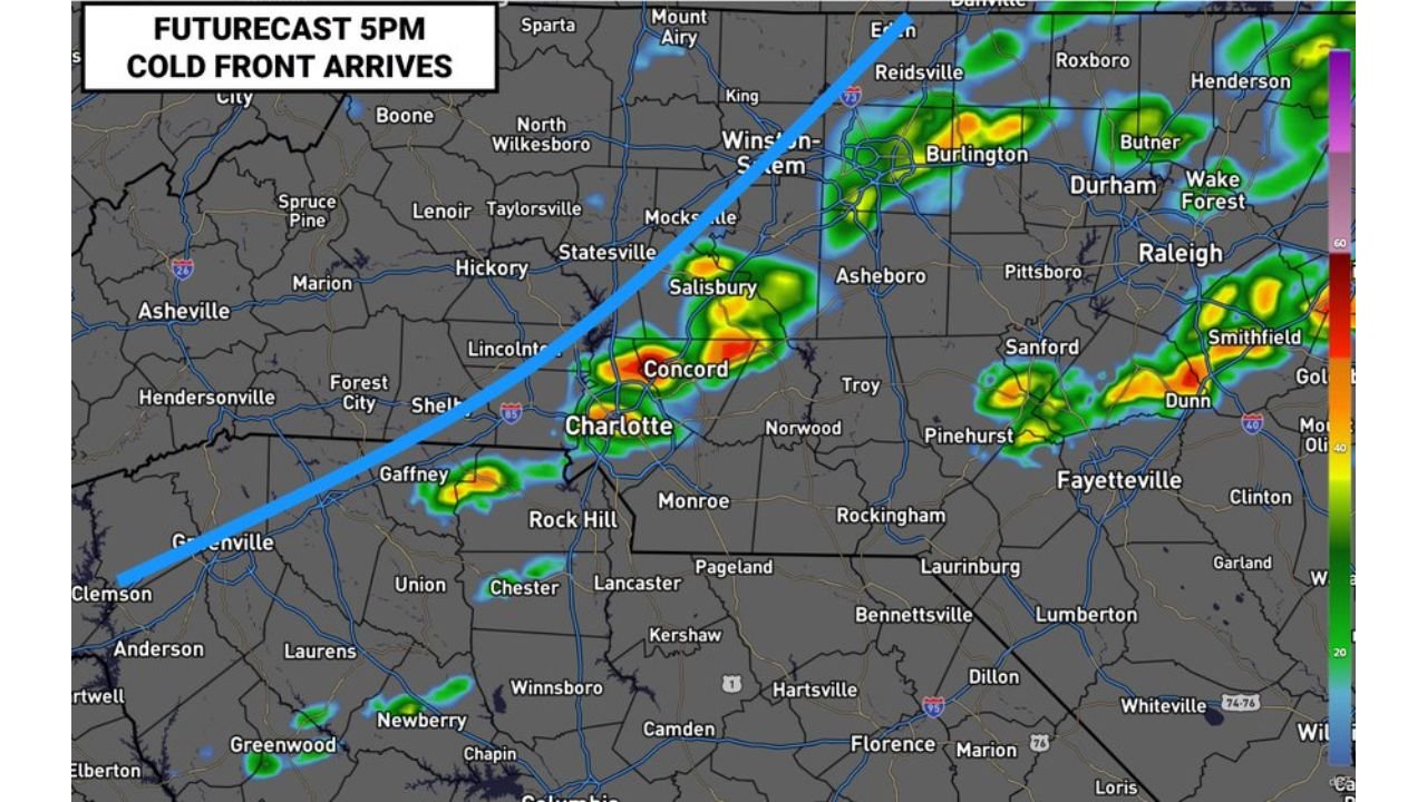
Where the Storms Will Be at 5 PM Friday
The futurecast valid at 5 PM Friday shows the cold front as a blue line sweeping from the Upstate South Carolina corridor through Charlotte and northeast toward Winston-Salem, Burlington and the Raleigh area. Active storm cells are forecast along and ahead of the front:
- Concord and Charlotte: Intense cells with red and orange cores directly along the frontal boundary
- Winston-Salem and Burlington: Heavy rain corridor stretching from the Triad toward Durham
- Raleigh, Wake Forest and Durham: Active cells pushing through the Triangle with the heaviest cores near Burlington and Butner
- Smithfield and Dunn: Storms continuing along the frontal line southeast of Raleigh
- Gaffney and Greenville, South Carolina: Southern end of the frontal boundary pushing through Upstate South Carolina
- Fayetteville and Pinehurst: Scattered cells southeast of the main frontal line
What Is Driving This Evening’s Activity
- Cold front dropping from northwest to southeast across both states — this boundary is the primary trigger for storm initiation Friday evening
- Less moisture available than overnight means storm coverage will be more scattered and less widespread
- Sunshine breaking out ahead of the front is actually adding instability that can fuel a few stronger storms along the frontal line as it pushes through
- The overall threat is scattered rather than widespread — some areas along the front will see heavy rain and gusty winds while nearby communities stay dry
What to Watch Friday Evening
- Charlotte and Concord face the most direct frontal passage around 5 PM — expect brief heavy rain and gusty winds with the strongest cells
- Raleigh, Durham and Wake Forest sit in the path of the Burlington storm cluster moving southeast through the early evening
- Winston-Salem and the Triad will see storms ahead of and along the front through the late afternoon
- South Carolina Upstate including Gaffney and Greenville will see the southern end of the frontal boundary push through before the main Charlotte corridor
- Conditions improve quickly behind the front — once the cold air moves through, skies will clear and temperatures will drop heading into the overnight hours
WaldronNews.com will continue tracking the cold front and evening storm chances across North Carolina and South Carolina and will provide updates as the front pushes through Charlotte and Raleigh Friday evening.