
Central United States Faces Enhanced Severe Weather Threat Mid to Late May With Greatest Outbreak Potential Tuesday May 26
OKLAHOMA CITY, Oklahoma — Severe weather potential is returning to the central United States during mid-to-late May 2026 as a large weather pattern shift allows storms to fire repeatedly across the region. The greatest outbreak potential is currently being highlighted for around Tuesday, May 26.
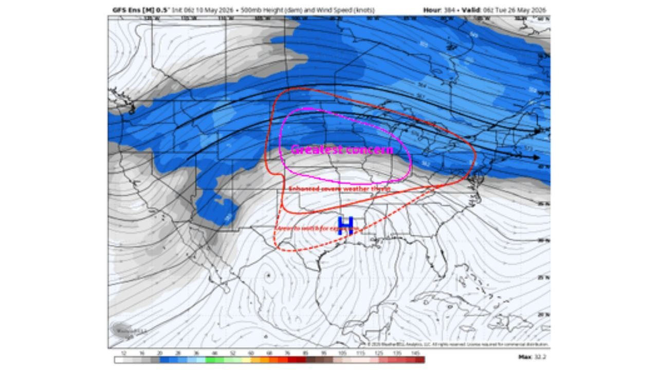
A trough amplifying across the western United States combined with an upper-level ridge shifting northward will allow the jet stream to flow in a more northwesterly direction, creating ideal conditions for serial severe weather events across the central United States.
What Is Driving This Pattern
Two major atmospheric features are working together to fuel this mid-to-late May severe weather setup:
- A trough, which is a dip in the jet stream that acts like a highway for storm energy, is amplifying across the western United States and will funnel cold upper-level winds toward the central states.
- An upper-level ridge of high pressure centered over the central United States is gradually moving northward, which allows the jet stream to go around it and take on a more northwesterly flow pattern that is highly favorable for severe thunderstorm development.
- This type of pattern, shown clearly in the atmospheric setup map, creates what forecasters call a serial severe weather threat, meaning multiple rounds of storms are possible over several days rather than just one isolated event.
Greatest Outbreak Potential Around May 26
The current outlook highlights the period around Tuesday, May 26 as the time frame with the greatest severe weather outbreak potential across the central United States. An enhanced severe weather threat zone is also indicated in the days leading up to May 26.
This is still more than 2 weeks away and exact storm tracks, timing and intensity will become clearer as the date approaches. However, the large-scale pattern strongly supports a significant severe weather episode for the central United States during this period.
Understanding Serial vs Progressive Storm Setups
The pattern setting up for mid-to-late May is a serial setup rather than a progressive one:
- A progressive pattern moves storm systems quickly across the country, limiting how long any one area stays at risk and generally keeping individual storm events shorter.
- A serial pattern, like what is developing here, keeps the storm-producing setup locked in place longer, allowing multiple rounds of severe thunderstorms to fire across the same region over several consecutive days.
- Serial setups are associated with higher cumulative severe weather impacts because communities may face repeated threats before the pattern finally breaks down.
What Residents Should Do Now
Residents across the central United States have time to prepare before this pattern arrives:
- Stay tuned to forecast updates through the week as confidence in the mid-to-late May severe weather timeline will increase significantly by May 19 to May 21.
- Ensure your weather alert apps are active and that household members know your severe weather shelter plan well before the May 26 timeframe arrives.
- Understand that this type of pattern can produce tornadoes, very large hail and damaging winds across the central United States over multiple days, so preparation now is critical.
WaldronNews.com will continue tracking this developing mid-to-late May severe weather pattern across the central United States and will provide updates as the greatest outbreak potential around Tuesday, May 26 comes into sharper focus.