
Texas, New Mexico, Missouri, Iowa, Tennessee and Louisiana Face Multiple 90F Plus Days From Dallas and Houston Through Des Moines and St. Louis May 14 Through May 18 With 80s Reaching the Ohio Valley
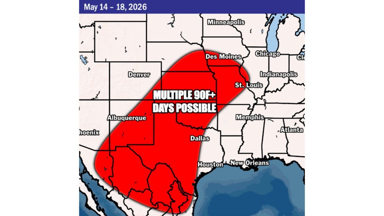
DALLAS, Texas — A significant heat buildup is forecast across a large portion of the central United States from Wednesday, May 14 through Sunday, May 18, 2026, with multiple days of 90F and above temperatures possible across a zone stretching from Houston and Dallas northward through St. Louis and Des Moines.
At least 80F temperatures are expected to extend into the Ohio Valley by next weekend as the warm pattern expands eastward.
Where 90F Plus Temperatures Are Expected
The Heat Risk map valid May 14 through May 18 shows a broad zone of multiple 90F plus days possible across the central United States:
- Dallas, Texas and Houston, Texas are located well within the core of the 90F plus zone and could see several consecutive days above 90F during this period.
- Albuquerque, New Mexico sits on the western edge of the heat zone and is also included in the multiple 90F plus day outlook for May 14 through May 18.
- Memphis, Tennessee and St. Louis, Missouri fall within the northern reaches of the 90F plus zone, where summer-like heat will arrive well ahead of the official start of summer.
- Des Moines, Iowa is highlighted near the northern tip of the heat zone, where 90F temperatures in mid-May would be notable and above normal for this time of year.
80s Expanding Into the Ohio Valley
Temperatures in the 80s are expected to expand into the Ohio Valley by next weekend as the warm pattern shifts eastward:
- Indianapolis, Indiana and Chicago, Illinois sit just outside the 90F plus zone but will still see well above normal warmth during the May 14 through May 18 period.
- Minneapolis, Minnesota is on the far northern fringe of the warming trend and will see temperatures trending warmer but likely staying below the 90F threshold during this period.
- The Ohio Valley expansion of 80F plus temperatures represents a significant pattern change from the cool and showery conditions affecting the region this week.
Why It Feels Like Summer Already
90F temperatures in May are not unheard of across the central United States, but multiple consecutive days at or above 90F this early in the season is a notable heat event. The ridge of high pressure building over the region will trap heat and limit cloud cover, allowing afternoon temperatures to climb rapidly each day from May 14 through May 18.
High humidity across Texas, Louisiana and parts of the Mississippi Valley will make actual air temperatures feel significantly hotter than the thermometer reading during peak afternoon hours.
Heat Safety for Next Week
Residents across Dallas, Houston, Memphis, St. Louis, Albuquerque and Des Moines should begin preparing now for this heat event:
- Limit outdoor activity during peak afternoon heating hours, generally between 12:00 PM and 6:00 PM, across all 90F plus areas during May 14 through May 18.
- Check on elderly neighbors, young children and pets daily throughout this heat period, as these groups face the highest risk of heat-related illness during multi-day heat events.
- Stay hydrated well before you feel thirsty, as thirst is already a sign of early dehydration when temperatures are above 90F.
WaldronNews.com will continue tracking this developing heat event across Texas, New Mexico, Missouri, Iowa, Tennessee and Louisiana including Dallas, Houston, Memphis, St. Louis, Albuquerque and Des Moines and will provide updates as temperatures and heat risk levels develop through Sunday, May 18.