
Gulf Coast, Georgia, South Carolina and North Carolina Face Damaging Winds, Hail and Isolated Tornado Risk Monday May 11 This Afternoon and Evening
ATLANTA, Georgia — A low-end severe weather threat is in place for Monday, May 11, 2026, stretching from the Gulf Coast northeastward through Georgia, South Carolina and North Carolina, with a few stronger storms still possible through the afternoon and evening hours.
Damaging winds, hail and an isolated tornado cannot be ruled out as storms develop across the region this afternoon and evening.
What the Outlook Shows
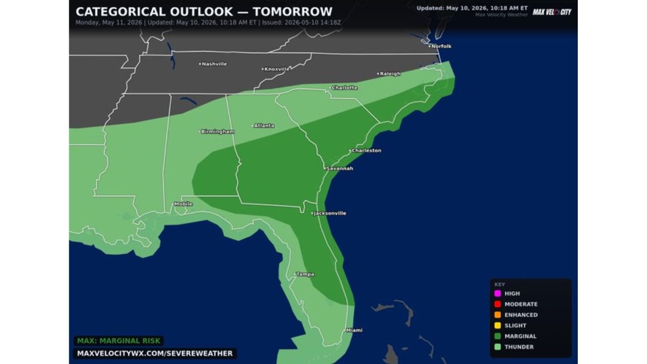
The Categorical Outlook valid Monday, May 11 shows a Marginal Risk zone covering a large portion of the Southeast:
- A Marginal Risk, the lowest level of severe weather risk on the outlook scale, covers areas from the Gulf Coast northeastward through Georgia, South Carolina and North Carolina, meaning isolated severe storms are possible but a widespread outbreak is not expected.
- Atlanta, Georgia falls within the Marginal Risk zone and could see a strong to severe storm develop during the afternoon and evening hours Monday, May 11.
- Charleston, South Carolina and areas along the South Carolina and North Carolina coastlines are included in the outlook zone, where storms pushing off the Gulf Coast could maintain severe intensity as they move northeastward.
- Jacksonville, Florida sits near the southern edge of the threat area and faces a lower but non-zero chance of seeing a strong storm this afternoon and evening.
Threats to Watch For
Three specific threats are possible with any storm that reaches severe levels across the Gulf Coast, Georgia, South Carolina and North Carolina today:
- Damaging wind gusts are the most likely severe weather threat across the region Monday afternoon and evening, with any strong storm capable of producing gusts that can knock down trees and power lines.
- Hail is possible with stronger storm cells developing through the afternoon hours, particularly across Georgia and South Carolina where instability will be highest during peak heating.
- An isolated tornado cannot be ruled out anywhere within the Marginal Risk zone from the Gulf Coast through North Carolina, though the overall tornado threat remains low given the marginal nature of this outlook.
Timing for Monday
Storms are expected to develop and intensify through the afternoon and reach their peak threat level during the evening hours of Monday, May 11:
- Afternoon heating will trigger the first round of storm development across Georgia and the Gulf Coast states during the early-to-mid afternoon hours.
- The threat continues into the evening as storms push northeastward toward South Carolina and North Carolina.
- Conditions should gradually improve overnight as the system pushes offshore.
Safety Reminders for Today
Residents across Atlanta, Charleston and communities along the Gulf Coast through North Carolina should stay alert throughout the afternoon and evening:
- Keep weather alerts active on your phone all day Monday, May 11 as severe thunderstorm and tornado warnings can be issued with little notice under a Marginal Risk setup.
- If a warning is issued for your area, move immediately to an interior room on the lowest floor of a sturdy building and stay away from all windows.
- Do not wait to see the storm approaching before taking shelter, as damaging winds and hail can arrive faster than they appear on radar.
WaldronNews.com will continue tracking this low-end severe weather threat across the Gulf Coast, Georgia, South Carolina and North Carolina and will provide updates as storm development, damaging winds, hail and isolated tornado risk develop through Monday, May 11 evening.