
Nebraska, Kansas, South Dakota, Iowa and Missouri Brace for Damaging Winds and Tornado Threat Sunday Evening May 17 as Storm Line Expected to Fire Around 5 to 6 PM Pushing Through Overnight
OMAHA, Nebraska – The severe weather threat for Sunday, May 17 is shifting toward a damaging wind and tornado threat from a fast-moving line of storms expected to fire around 5:00 to 6:00 PM across northern Kansas, central and eastern Nebraska and southeast South Dakota and western Iowa. Rather than isolated supercells with a tornado and hail focus, a cold front crashing into a very moist and energized warm sector is now expected to produce a fast-moving storm line that pushes through Nebraska and Kansas and moves into Minnesota, Iowa and Missouri through the late evening and overnight hours.
What Changed and Why It Matters
The forecast for Sunday, May 17 has evolved in an important way that residents across Nebraska, Kansas, South Dakota, Iowa and Missouri need to understand:
- Earlier forecasts favored isolated supercell thunderstorms with a strong hail and tornado focus. The updated picture now leans toward a linear storm mode, meaning a long line of storms moving together rather than individual rotating supercells.
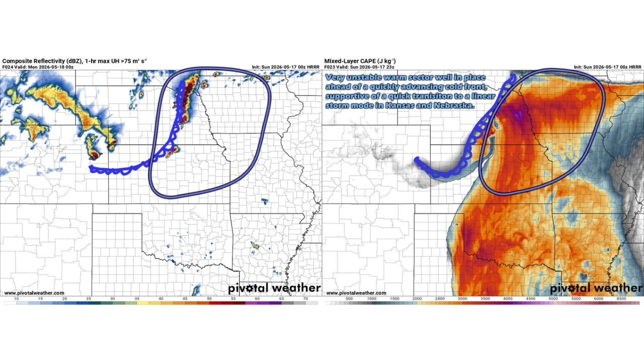
- A cold front rapidly advancing into a very unstable and moist warm sector across Kansas and Nebraska is driving this transition toward a storm line rather than discrete supercells.
- While supercells may briefly form as storms initially fire, the transition to a linear mode is expected to happen quickly, limiting the window for supercells to produce tornadoes.
The Threats From a Linear Storm Mode
A fast-moving storm line brings a different but still very dangerous set of hazards for Sunday, May 17:
- Damaging winds become the primary threat with a linear storm mode, as the line of storms can produce widespread straight-line wind gusts capable of downing trees and power lines across a very large area simultaneously.
- Embedded tornadoes within the storm line remain possible, particularly in the early stages before the line fully organizes across northern Kansas, central and eastern Nebraska and southeast South Dakota.
- The storm complex will push through Nebraska and Kansas first before moving into Minnesota, Iowa and Missouri through the late evening and overnight hours on Sunday, May 17.
Timing to Know for Sunday May 17
The storm timeline for Sunday, May 17 is as follows:
- Storms are expected to fire around 5:00 to 6:00 PM across the primary threat zone covering northern Kansas, central and eastern Nebraska and southeast South Dakota and western Iowa.
- The storm complex will continue pushing east and northeast through Nebraska and Kansas through the evening hours.
- Minnesota, Iowa and Missouri should expect the storm line to arrive through the late evening into overnight hours on Sunday, May 17 into Monday morning, May 18.
States and Regions Facing the Storm Line Sunday
- Northern Kansas and central and eastern Nebraska are in the primary firing zone for storm initiation around 5:00 to 6:00 PM Sunday and face the greatest damaging wind and embedded tornado threat as the line organizes.
- Southeast South Dakota and western Iowa are also within the initial threat corridor as the cold front pushes the storm line northeast Sunday evening.
- Minnesota, Iowa and Missouri face the arriving storm complex through the late evening and overnight hours and should not let their guard down just because storms arrive after dark. Overnight severe weather is especially dangerous because many people are asleep when warnings are issued.
What You Should Do Before 5 PM Sunday
Anyone across Nebraska, Kansas, South Dakota, Iowa and Missouri needs to complete outdoor activities and finalize shelter plans before 5:00 PM Sunday, May 17. Keep weather alerts active on your phone through the entire night. Damaging winds from a fast-moving storm line can arrive with very little warning, particularly after dark. Do not assume the threat has passed until all severe weather warnings for your area have expired.
WaldronNews.com will continue tracking this damaging wind and tornado threat across Nebraska, Kansas, South Dakota, Iowa and Missouri and will provide updates as storm initiation, wind reports and tornado activity develop through Sunday evening and overnight May 17 into May 18.