
Nebraska, South Dakota, Iowa and Minnesota Face Potentially Dangerous Tornado Event Sunday Afternoon With EF3 Tornadoes Possible, 80 mph Wind Gusts and 2 Inch Hail Including Omaha, Sioux Falls and Sioux City Starting 4 to 6 PM CDT
OMAHA, Nebraska – A potentially dangerous tornado event is taking shape for Sunday afternoon and evening, May 17, with supercells expected to fire between 4:00 and 6:00 PM CDT across Nebraska, South Dakota, Iowa and Minnesota. The greatest tornado threat zone is centered on Omaha, Sioux City and Sioux Falls, where intense EF3 or stronger tornadoes are possible along with 80 mph wind gusts and 2 inch or larger hail.
Two Dangerous Scenarios for Sunday Afternoon
The outcome of Sunday, May 17 depends heavily on how quickly storms grow upscale, and both scenarios carry serious threats:
- If supercells remain discrete in the volatile triple point and warm front environment, intense long-tracked tornadoes and 2 inch or larger hail are possible across Nebraska, South Dakota and Iowa during the 4:00 to 6:00 PM CDT initiation window. This is the most dangerous tornado scenario.
- If storms grow upscale quickly into a storm line, the primary threat shifts to damaging winds up to 80 mph and embedded tornadoes as the complex pushes through Nebraska, Iowa and into Minnesota. EF3 or stronger embedded tornadoes remain possible even within the line.
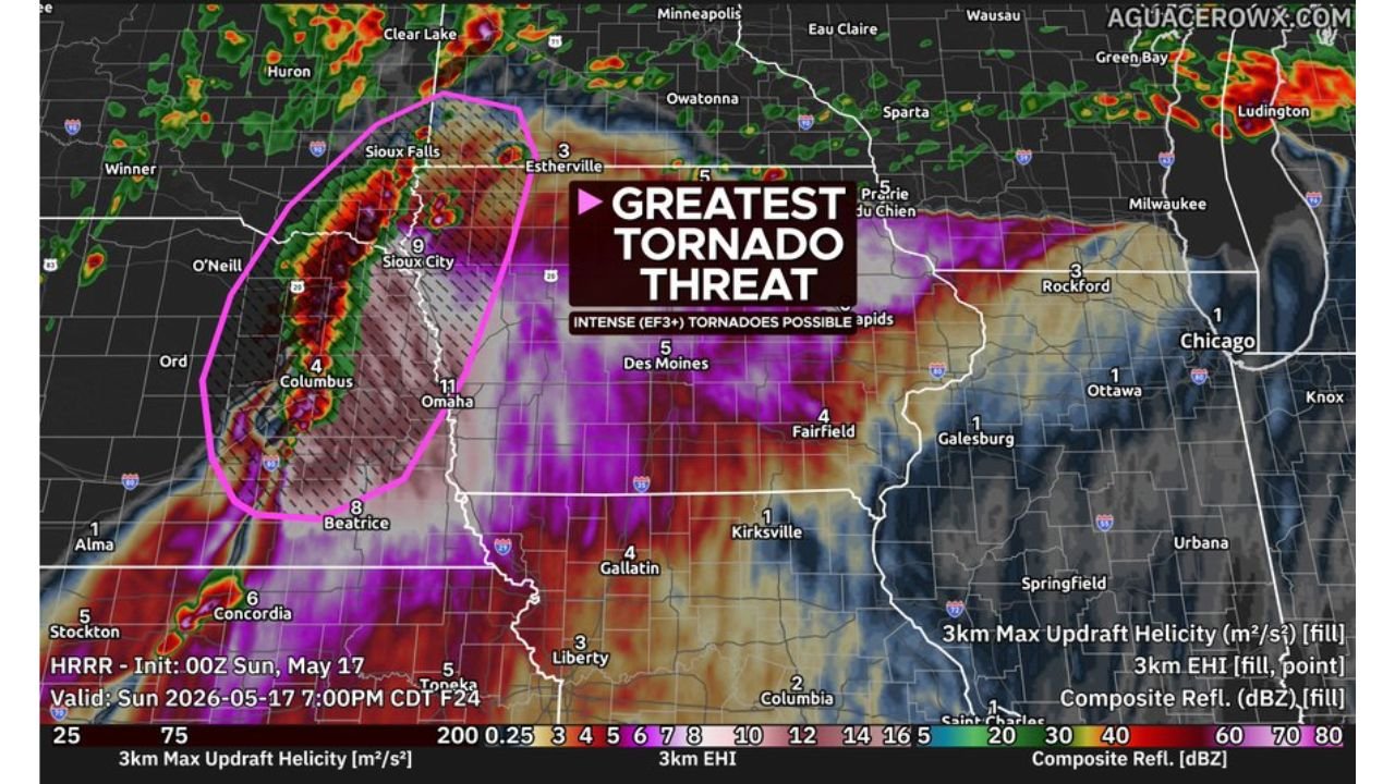
The Greatest Tornado Threat Zone Right Now
Forecast data valid for Sunday, May 17 at 7:00 PM CDT shows the following communities inside the greatest tornado threat corridor:
- Omaha, Nebraska carries the highest storm rotation values on the map at 11 and sits squarely inside the greatest tornado threat zone, facing intense EF3 or stronger tornadoes and 80 mph wind gusts Sunday afternoon and evening.
- Sioux City, Iowa shows a value of 9 on the rotation map and is within the greatest tornado threat zone alongside Omaha for Sunday, May 17.
- Beatrice, Nebraska shows a value of 8 and sits inside the greatest tornado threat corridor facing all severe hazards Sunday afternoon.
- Sioux Falls, South Dakota is outlined within the greatest tornado threat zone and faces intense EF3 or stronger tornadoes possible Sunday afternoon and evening.
- O’Neill and Columbus, Nebraska are both within the greatest tornado threat zone and should be sheltered and weather-alert ready before 4:00 PM CDT Sunday.
- Concordia, Kansas shows a value of 6 on the map and sits on the southern edge of the greatest threat corridor Sunday afternoon.
- Estherville and Des Moines, Iowa show values of 5 and fall within the broader severe weather threat area for Sunday, May 17.
What EF3 or Stronger Tornadoes Mean for Your Community
An EF3 tornado carries winds of 136 to 165 mph and is capable of destroying well-built homes, overturning trains, uprooting trees and throwing vehicles significant distances. EF4 and EF5 tornadoes in the same family carry winds above 166 mph and can level entire neighborhoods and strip pavement from roads. The forecast is flagging EF3 or stronger tornadoes as possible in the Omaha, Sioux City, Sioux Falls and Beatrice corridor this Sunday afternoon, which means residents in these areas face a life-threatening tornado risk starting around 4:00 to 6:00 PM CDT.
80 mph Wind Gusts Add a Second Major Threat
Even if tornadoes do not materialize as the most dominant threat Sunday, 80 mph wind gusts from a fast-moving storm line are capable of widespread destruction across a large area. 80 mph winds can snap mature trees at the trunk, collapse poorly constructed buildings, destroy mobile homes, down power lines and flip high-profile vehicles. The wind threat alone warrants the same respect as a tornado threat across Nebraska, Iowa, South Dakota and Minnesota on Sunday, May 17.
Timing Is Critical Sunday Afternoon
- Supercells are expected to develop between 4:00 and 6:00 PM CDT across the greatest tornado threat zone covering Omaha, Sioux City, Sioux Falls, O’Neill, Columbus and Beatrice.
- Storm growth upscale into a line could occur quickly after initial development, shifting the threat toward damaging winds and embedded tornadoes through the evening hours.
- Minnesota, Iowa and Missouri should expect the storm complex to arrive through the late evening and overnight hours Sunday into Monday.
What You Must Do Before 4 PM Sunday
Anyone across Omaha, Sioux City, Sioux Falls, O’Neill, Columbus, Beatrice and surrounding Nebraska, South Dakota and Iowa communities must be fully sheltered and weather-alert ready before 4:00 PM CDT Sunday, May 17. Go to the lowest interior room of a sturdy building now. Keep weather alerts active on your phone all afternoon and evening. Do not be outside or on the road when storms fire between 4 and 6 PM. An EF3 or stronger tornado gives almost no time to react once a warning is issued.
WaldronNews.com will continue tracking this potentially dangerous tornado event across Nebraska, South Dakota, Iowa and Minnesota and will provide updates as supercell development, tornado warnings and wind reports emerge throughout Sunday afternoon and evening, May 17.