
Nebraska and South Dakota Face Numerous Tornadoes Including EF2 or Stronger Sunday May 17 Between 3 and 7 PM Including Sioux City, Pierce, Yankton and Omaha With Several Tornadoes Possible From Lincoln to Beatrice
SIOUX CITY, Iowa – A critical 3:00 to 7:00 PM CDT window on Sunday, May 17 will allow rotating supercells to fire along the I-29 corridor between Omaha and Sioux Falls, threatening numerous tornadoes including EF2 or stronger across a bull’s eye zone centered on Sioux City, Pierce and Yankton. This is one of the most precisely targeted tornado setups seen this season, with four distinct tornado threat zones now drawn across Nebraska, South Dakota, Iowa and Kansas.
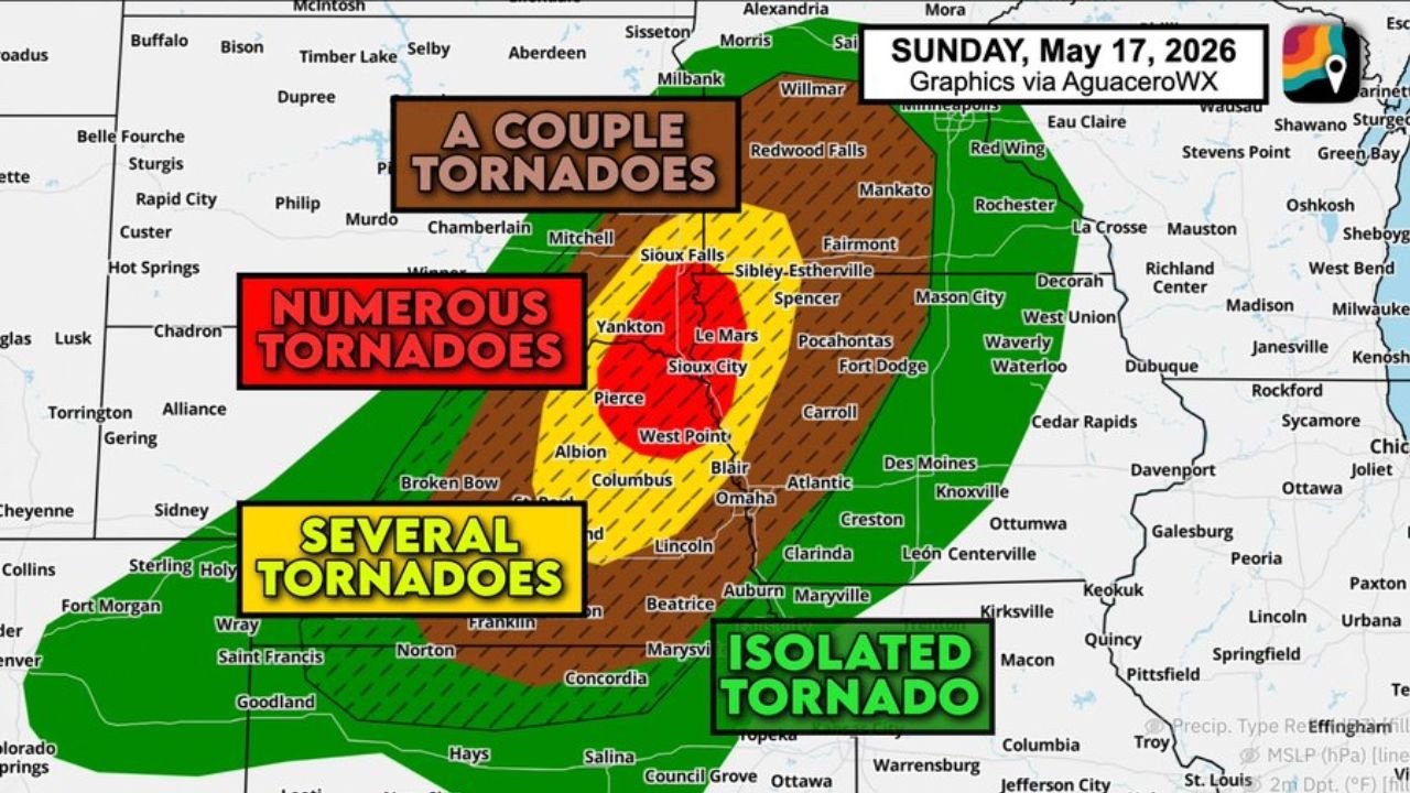
Four Tornado Threat Zones for Sunday May 17
The map for Sunday, May 17, 2026 breaks the tornado threat into four clearly defined zones:
- Numerous Tornadoes zone shown in red covers the highest-danger corridor centered on Sioux City, Pierce, Yankton, Albion, West Point and Blair, Nebraska and South Dakota. This is where the greatest concentration of tornadoes is expected between 3:00 and 7:00 PM CDT Sunday.
- Several Tornadoes zone shown in yellow-orange extends the threat through Columbus, Omaha, Lincoln, Beatrice, Auburn and Maryville, where multiple tornadoes are possible Sunday afternoon and evening.
- A Couple Tornadoes zone shown in brown covers a wider swath including Sioux Falls, Yankton, Estherville, Le Mars, Sibley, Fairmont, Redwood Falls, Mankato and Spencer, where a few tornadoes are expected Sunday.
- Isolated Tornado zone shown in green covers the outermost area including Clarinda, Leon, Centerville, Macon, Warrensburg, Concordia, Council Grove, Salina and Hays, where a single tornado is possible Sunday afternoon and evening.
The Bull’s Eye: Sioux City, Pierce and Yankton
Sioux City, Pierce and Yankton are specifically named as sitting in the bull’s eye of the Sunday, May 17 tornado threat. These communities face the highest probability of seeing numerous tornadoes including EF2 or stronger during the critical 3:00 to 7:00 PM CDT supercell window. An EF2 tornado carries winds of 111 to 135 mph and is capable of destroying mobile homes, snapping large trees and ripping roofs off well-built homes. If you live in or near Sioux City, Pierce or Yankton you need to be sheltered before 3:00 PM CDT Sunday.
The Critical 3 to 7 PM CDT Window
Rotating supercells are expected to become established during the mid to late afternoon hours, specifically between 3:00 and 7:00 PM CDT Sunday, May 17. During this window, storms growing tall enough will encounter changing winds with height in the atmosphere that cause them to spin and produce very large destructive hail and EF2 or stronger tornadoes. After 7:00 PM CDT, a cold front is expected to catch up to the storms and merge them into a line, shifting the threat toward damaging winds and embedded tornadoes.
Additional Cities in the Tornado Threat Zones
- Omaha and Columbus, Nebraska fall within the Several Tornadoes zone and face multiple tornado threats Sunday afternoon alongside Lincoln and Beatrice.
- Sioux Falls, South Dakota sits within the A Couple Tornadoes zone along with Mitchell, Chamberlain and Aberdeen area communities.
- Le Mars, Spencer, Fort Dodge, Carroll and Pocahontas, Iowa are within the A Couple Tornadoes zone for Sunday, May 17.
- Broken Bow, Chadron, Alliance and Torrington sit on the western edges of the threat zone and should monitor conditions closely Sunday afternoon.
- Des Moines, Atlantic, Creston and Ottumwa, Iowa fall within the broader severe weather area for Sunday, May 17.
What You Must Do Before 3 PM Sunday
Anyone from Sioux City, Pierce and Yankton through Omaha, Lincoln and Beatrice must be fully sheltered in the lowest interior room of a sturdy building before 3:00 PM CDT Sunday, May 17. Do not wait for a tornado warning to seek shelter if supercells are developing near your location. Keep weather alerts active on your phone all afternoon. Mobile homes and vehicles offer no protection from EF2 or stronger tornadoes. Get to a sturdy structure now.
WaldronNews.com will continue tracking this numerous tornado threat across Nebraska, South Dakota and Iowa and will provide updates as supercell development, tornado warnings and damage reports emerge throughout Sunday afternoon, May 17.