
Kansas and Nebraska Face Level 4 Moderate Risk Severe Weather Outbreak Monday May 18 With 3 Inch Plus Hail and EF2 to EF3 Tornadoes Including Wichita, Topeka, Omaha and Hastings
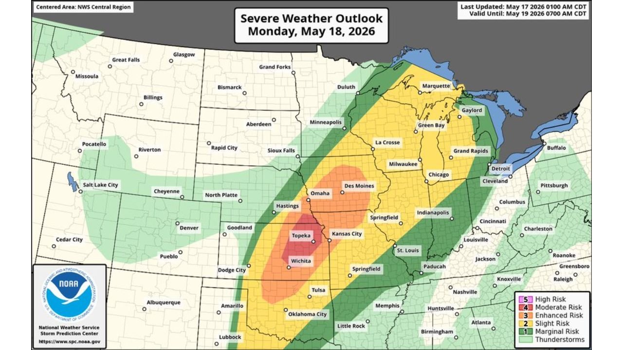
WICHITA, Kansas – A Level 4 Moderate risk of severe weather is in place across Kansas and Nebraska for Monday, May 18, 2026, with an outbreak of severe weather possible driven primarily by 3 inch or larger hail and EF2 to EF3 or stronger tornadoes. Wichita, Topeka, Omaha and Hastings sit inside the highest-risk corridor, with damaging winds also possible across the broader threat zone valid through Tuesday, May 19 at 7:00 AM CDT.
Risk Levels Across the Full Outbreak Zone Monday May 18
The official Severe Weather Outlook valid through Tuesday morning, May 19 at 7:00 AM CDT shows five distinct risk categories stretching from the Plains through the Great Lakes:
- Level 4 out of 5 Moderate Risk covers the core outbreak corridor centered on Wichita, Topeka, Omaha and Hastings, where 3 inch or larger hail and EF2 to EF3 or stronger tornadoes are possible Monday.
- Level 3 out of 5 Enhanced Risk surrounds the Moderate zone covering Kansas City, Des Moines, Sioux Falls, North Platte and Goodland, where all severe hazards remain likely Monday.
- Level 2 out of 5 Slight Risk extends the threat into Minneapolis, La Crosse, Milwaukee, Chicago, Springfield, Tulsa and Oklahoma City, where isolated severe storms are possible Monday.
- Level 1 out of 5 Marginal Risk covers the outermost zone reaching Duluth, Green Bay, Grand Rapids, Indianapolis, Louisville, Nashville, Memphis, Little Rock and Dodge City.
- A Thunderstorm zone extends the general storm coverage into Michigan, Ohio, Detroit, Cleveland, Pittsburgh and surrounding Great Lakes communities through Tuesday morning, May 19.
What 3 Inch Plus Hail Does to Property
3 inch or larger hail is golf ball to baseball size and beyond, representing some of the most destructive hail possible from a severe thunderstorm. At this size, hail will total vehicles instantly, shatter windows, punch through roofs, destroy solar panels and injure or kill anyone caught outdoors. The Level 4 Moderate zone centered on Wichita and Topeka faces this extreme hail threat on Monday, May 18. Move all vehicles under solid cover before Monday afternoon.
Cities Inside the Level 4 Moderate Zone
- Wichita, Kansas sits at the center of the Moderate risk and faces the greatest combined threat of 3 inch plus hail, EF2 to EF3 tornadoes and damaging winds Monday afternoon and evening.
- Topeka, Kansas is squarely inside the Moderate corridor and should be fully prepared for all severe hazards before Monday afternoon.
- Omaha and Hastings, Nebraska fall within the Moderate risk zone and face 3 inch plus hail and a real EF2 to EF3 tornado threat Monday.
- Kansas City and Springfield, Missouri sit within the Enhanced risk zone bordering the Moderate corridor and face significant severe weather Monday.
- Des Moines, Iowa and Sioux Falls, South Dakota are within the Enhanced risk area and should monitor conditions closely all day Monday, May 18.
EF2 to EF3 Tornadoes Are a Life-Threatening Risk
An EF2 tornado carries winds of 111 to 135 mph while an EF3 reaches 136 to 165 mph, both capable of destroying homes, overturning vehicles and producing life-threatening flying debris across wide areas. The Moderate risk zone for Monday, May 18 highlights EF2 to EF3 or stronger tornadoes as a real possibility for Wichita, Topeka, Omaha and Hastings. Anyone in these cities must have a confirmed tornado shelter plan before Monday morning.
Wider Threat Into the Great Lakes and Upper Midwest
Monday, May 18 is not just a Plains event. The threat zone stretches far to the northeast:
- Milwaukee, Chicago and Grand Rapids, Michigan fall within the Slight risk zone and face isolated severe storm potential Monday.
- Green Bay, Marquette and Gaylord are within the Slight to Marginal risk area across the northern Great Lakes region Monday.
- Duluth, Minnesota sits on the northern edge of the threat zone for Monday, May 18.
What You Must Do Before Monday Morning
Anyone across Wichita, Topeka, Omaha, Hastings and surrounding Kansas and Nebraska communities must finalize severe weather shelter plans before Monday morning, May 18. Know your tornado shelter location. Move vehicles under cover before Monday afternoon. Keep weather alerts active on your phone all day Monday. Do not be outdoors or on the road during peak storm hours Monday afternoon and evening. A 3 inch hail stone or EF3 tornado can be lethal.
WaldronNews.com will continue tracking this Level 4 Moderate severe weather outbreak across Kansas and Nebraska and will provide updates as tornado warnings, hail reports and wind damage emerge throughout Monday, May 18.