
Michigan Faces Increased Storm Chances and Organized Lines of Storms Beginning Around Saturday June 7 Through Wednesday June 10 as Current Sunny Stretch Ends
DETROIT, Michigan — The stretch of sunny skies and beautiful weather currently locked over Michigan is expected to break apart around Saturday, June 7, 2026, with a more unsettled and humid pattern taking over through at least Wednesday, June 10, 2026. Warm temperatures will continue but rising storm chances, organized storm clusters and pop-up afternoon storms are all expected to become more frequent across Michigan during this window. Residents planning outdoor events in early June should pay close attention to this approaching pattern shift.
What Michigan Is Seeing Right Now
Michigan is currently sitting under sunny skies, no rain and overall comfortable conditions. This pleasant stretch has been in place for some time but forecasters are clear that it will not last beyond the first week of June 2026. The atmosphere is set to change significantly around Saturday, June 7, so enjoy the quiet weather while it remains.
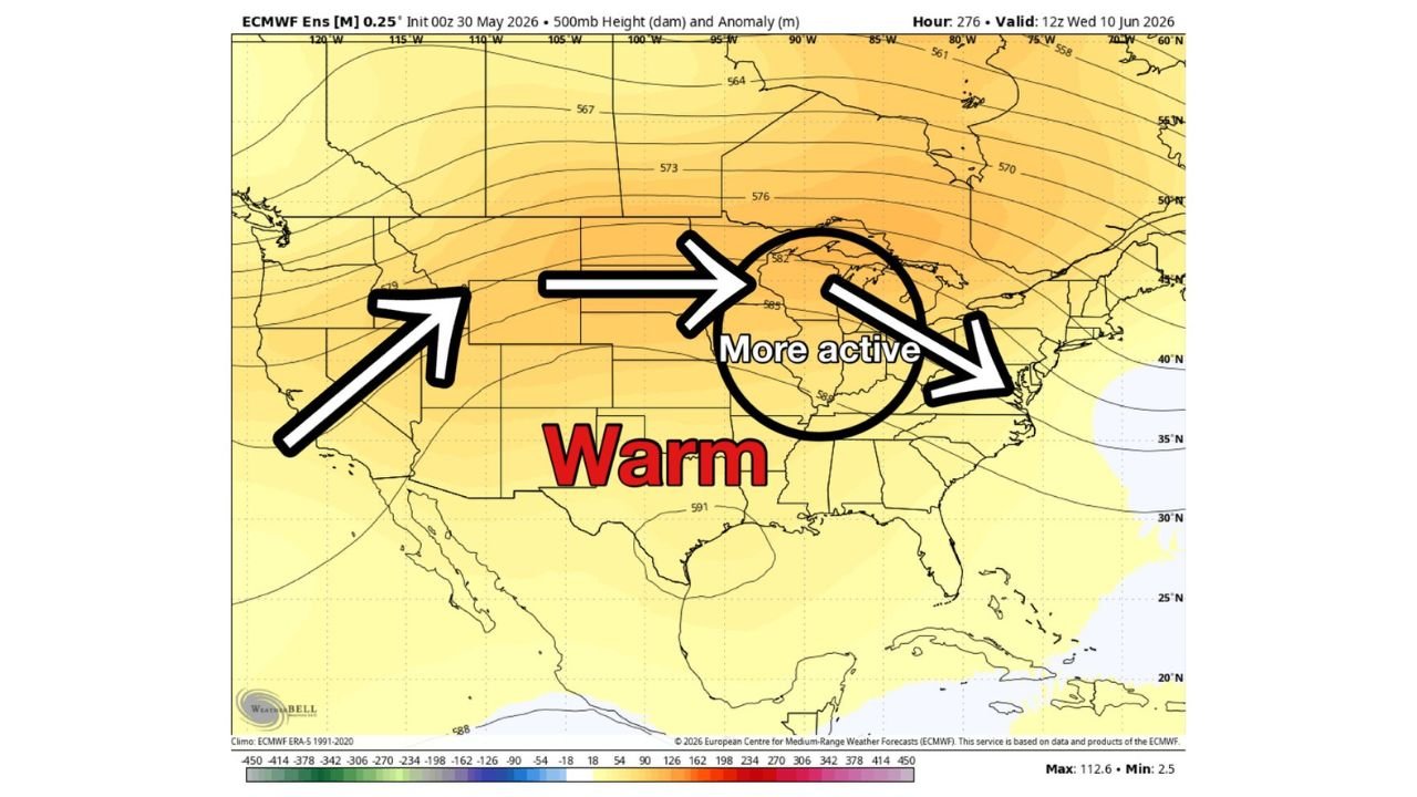
When the Pattern Shifts and What Replaces It
The current sunny pattern breaks down around Saturday, June 7, 2026, giving way to a warmer and more storm-prone stretch across Michigan. A ridge pattern, meaning an area of elevated warm air arching across the United States, builds in shortly after and sets the stage for increased storm activity. This ridge keeps temperatures warm but also pumps up humidity and storm chances across Michigan beginning around June 7 and running through Wednesday, June 10, 2026.
What a Ridge Pattern Means for Local Residents
A ridge is not a storm system itself — it is a setup in the upper atmosphere that acts like a heat dome. It traps warm, moist air near the surface and creates the fuel that storms need to fire up during the hottest part of the day. For Michigan, this particular ridge positioning is expected to support multiple rounds of storm activity between Saturday, June 7 and Wednesday, June 10, 2026.
The Three Storm Threats Michigan Faces Starting June 7
The forecast identifies three distinct storm types that Michigan should prepare for beginning around Saturday, June 7, 2026:
- Storm complexes are large, organized clusters of thunderstorms that travel together across great distances, often producing widespread heavy rain, gusty winds and frequent lightning over a broad area. The forecast specifically identifies Michigan as having a heightened chance of storm complexes during the June 7 through June 10 window based on the positioning of the ridge and jet stream.
- Squall lines are long walls of powerful storms that can stretch for hundreds of miles and race through an area quickly, bringing intense wind gusts and heavy downpours in a short period of time. The setup between Saturday, June 7 and Wednesday, June 10 is specifically favoring this type of storm threat for Michigan, making it one of the more notable concerns during this period.
- Pop-up afternoon storms are quick-developing thunderstorms that fire up during the peak heating hours of the day, typically in the early to mid afternoon. Once the ridge sets in across Michigan around June 7, these pop-up storms are expected to become a daily possibility through at least June 10, 2026.
Is This Pattern Unusual for Michigan in June
This type of summer storm pattern is not unusual for Michigan and occurs regularly around this time each year. The ridge sets in, humidity rises, and afternoon and evening storm chances climb as a result. What makes this stretch worth watching is the forecast agreement on storm complexes and organized lines of storms targeting Michigan specifically between June 7 and June 10, 2026, rather than just isolated pop-up activity.
The Bottom Line for Michigan Heading Into June
Warm temperatures will continue across Michigan but the weather pattern is about to become noticeably more active. The current quiet stretch ends around Saturday, June 7, 2026, and residents should expect higher humidity, more frequent storms and potential for organized and fast-moving storm systems through at least Wednesday, June 10, 2026. Anyone with outdoor plans during that window should monitor the forecast closely as the date approaches.
WaldronNews.com will continue tracking the approaching pattern shift and storm chances across Michigan and will provide updates as conditions between Saturday, June 7 and Wednesday, June 10, 2026 develop.