
Kansas Faces Two Active Severe Storms Near Emporia and Burlington at 9:28 PM Monday June 1 Including Hail and Very High Winds With Slight Rotation in the Southern Storm
EMPORIA, Kansas — Two active and dangerous storms are moving through east-central Kansas as of 9:28 PM CDT on Monday, June 1, 2026, with distinctly different threats from each cell. The northern storm near Allen, Reading and Osage City is producing hail, while the southern storm near Olpe and Burlington is delivering hail, very high winds and has slight rotation detected at this time. Anyone in the path of either storm must take shelter immediately and not wait to see or hear anything before acting.
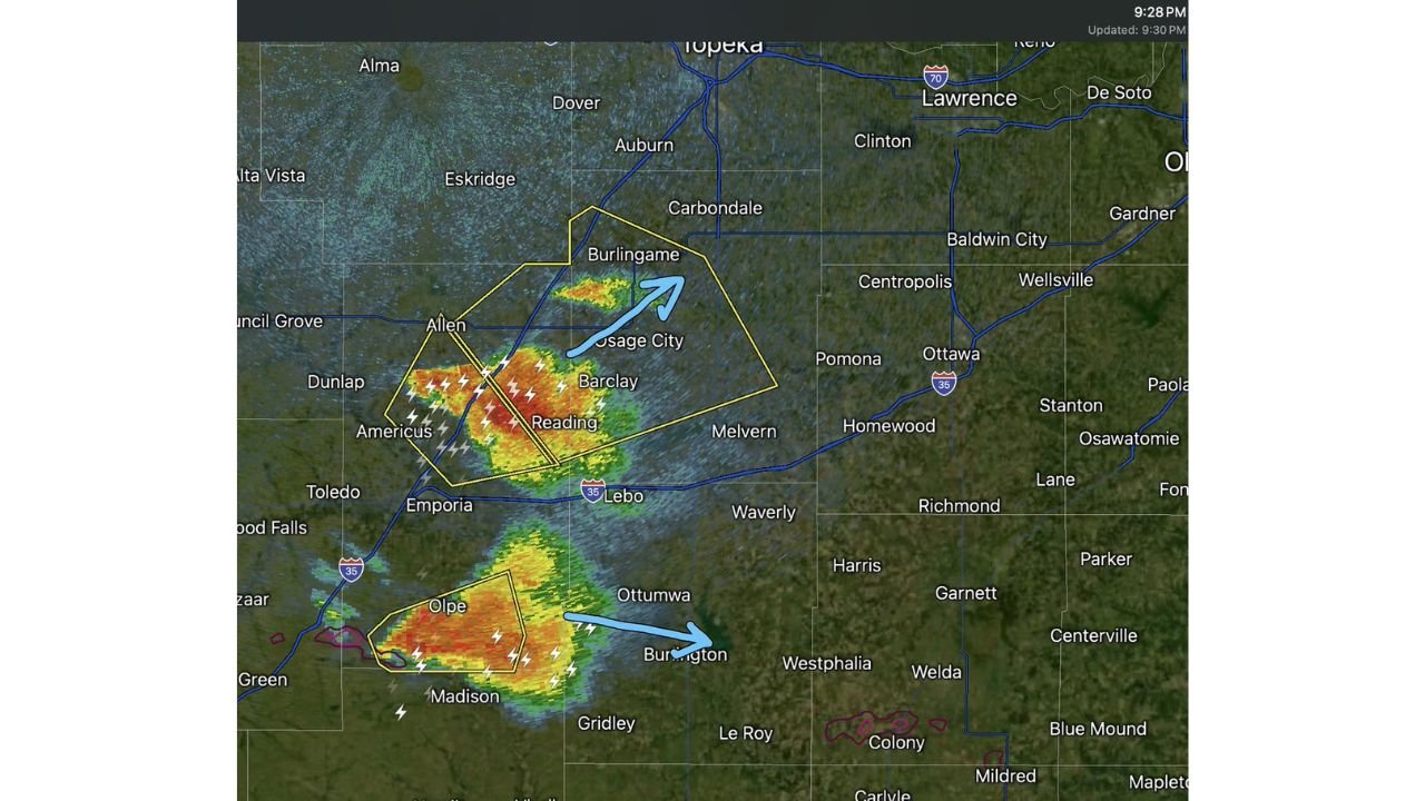
The Northern Storm: Hail Threat Near Allen, Reading and Osage City
The northern storm is the larger of the two cells on radar as of 9:28 PM CDT Monday, June 1, 2026, and forecasters identify hail as its primary threat. The storm is positioned across the Allen, Reading, Barclay and Osage City area of east-central Kansas, with radar showing intense returns in the red and dark red range indicating a powerful core. The blue arrow on the radar image indicates this storm is tracking toward the northeast, putting Burlingame and the surrounding communities in its forward path.
The Southern Storm: Hail, Very High Winds and Slight Rotation Near Olpe and Burlington
The southern storm is the more immediately dangerous of the two cells based on the information available as of 9:28 PM CDT Monday, June 1, 2026. This storm near Olpe and Burlington, Kansas is producing hail and very high winds, and forecasters specifically note slight rotation is detected within this storm at this time. Slight rotation means this thunderstorm is beginning to spin internally, a warning sign that conditions could deteriorate quickly toward tornado development.
What Slight Rotation in a Storm Means for Residents
Rotation inside a thunderstorm is caused by wind patterns that cause the updraft of a storm to begin spinning like a top. Even slight rotation is a serious signal because storms can intensify their rotation rapidly and without much warning, potentially producing a tornado within minutes of the first signs of spin being detected on radar. Residents near Olpe, Burlington, Madison and Gridley, Kansas should treat the southern storm as a direct tornado threat and move to shelter right now rather than waiting for a warning to be issued.
Cities in the Path of Both Storms as of 9:28 PM CDT
The two storms are tracking eastward across east-central Kansas as of 9:28 PM CDT on Monday, June 1, 2026. Here are the communities falling within or immediately ahead of each cell:
- Allen, Reading, Barclay and Osage City, Kansas are within or immediately adjacent to the northern hail-producing storm as of 9:28 PM CDT, with the cell showing a strong radar signature across this corridor.
- Americus and Dunlap, Kansas are on the western flank of the northern storm’s polygon, sitting within the warning area on the 9:28 PM CDT radar image.
- Burlingame, Kansas is directly in the northeast path of the northern storm based on the radar movement arrow shown at 9:28 PM CDT and residents there should be sheltering now.
- Melvern and Lebo, Kansas lie to the east of the northern storm’s current position and are in the forward path as the cell continues tracking northeast from the 9:28 PM CDT position.
- Olpe and Burlington, Kansas are within the southern storm’s warning polygon at 9:28 PM CDT and are facing the most dangerous combination of threats including hail, very high winds and slight rotation.
- Madison and Gridley, Kansas are visible to the south and southeast of the southern storm’s current position and are directly in the forward path as of 9:28 PM CDT.
- Ottumwa and Westphalia, Kansas lie to the east of the southern storm and are in the anticipated track as the cell moves from the 9:28 PM CDT radar position.
- Emporia, Kansas sits between the two storm cells on the 9:28 PM CDT radar image and should remain on high alert for activity from both the northern and southern storms through the evening.
- Waverly, Le Roy and Colony, Kansas are visible to the east on the radar map and should monitor conditions closely as both storms continue moving through east-central Kansas after 9:28 PM CDT.
What You Must Do Right Now
If you are in Olpe, Burlington, Allen, Reading, Osage City, Burlingame, Emporia or any surrounding community in east-central Kansas, move to the lowest interior room of the nearest sturdy building immediately. The southern storm’s slight rotation makes a tornado possible with little additional warning, and the northern storm’s hail core is intense enough to cause serious injury to anyone caught outdoors. Do not go outside to watch either of these storms.
WaldronNews.com will continue tracking both active severe storms across east-central Kansas including the rotation-producing southern cell near Olpe and Burlington and will provide updates as conditions develop beyond 9:28 PM CDT Monday, June 1, 2026.