
Ohio, Indiana, Kentucky and Pennsylvania Get Last Dry Window Through June 5 Before Active Pattern Returns After June 6
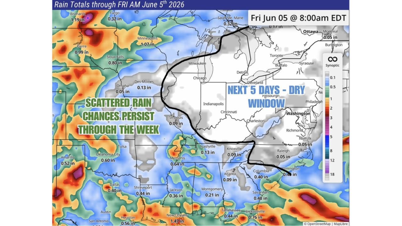
OHIO VALLEY — The Eastern Ohio Valley and surrounding states are sitting inside a 5-day dry window that runs through Friday morning, June 5, 2026, and forecasters are urging residents to take full advantage of the dry stretch while it lasts. Rain totals through Friday, June 5 at 8:00 AM EDT show near-zero accumulations across the dry zone, but an active and potentially significant weather pattern is forecast to move in beyond June 6, making this one of the last extended dry stretches the region may see for some time.
The Dry Zone Through June 5
The rainfall accumulation map valid through Friday, June 5 at 8:00 AM EDT shows a clearly defined dry pocket across the Eastern Ohio Valley and Mid-Atlantic. Rain totals within the dry window are minimal:
| City | Rain Total Through June 5 |
|---|---|
| Indianapolis | Trace |
| Cincinnati | Trace |
| Cleveland | Trace |
| Pittsburgh | Trace |
| Columbus area | Trace |
| Charleston, West Virginia | Trace |
| Philadelphia | Trace |
| Washington D.C. | Trace |
| Knoxville | 0.09 in |
| Nashville | 0.13 in |
| Raleigh | 0.05 in |
| Norfolk | 0.05 in |
The gray shading across this zone on the map confirms the near-zero precipitation expected through Friday morning, a stark contrast to the active rainfall showing up across the Plains and Gulf Coast.
Where Rain Is Falling Elsewhere
Outside the dry window, scattered rain chances persist through the week across the central and southern United States. Notable accumulations through June 5 include:
- New Orleans: 1.47 inches
- Bismarck: 1.19 inches
- Minneapolis: 1.07 inches
- Pierre, South Dakota: 0.99 inches
- Sioux Falls: 0.80 inches
- Houston: 0.56 inches
- Jacksonville: 0.76 inches
- Tallahassee: 0.44 inches
The central Plains and Gulf Coast are seeing the most active rainfall during this period, with scattered chances persisting across Oklahoma, Texas, Arkansas and the Southeast.
The Warning: Active Pattern Returns After June 6
The critical message from forecasters is that the current dry stretch has an expiration date. Beyond June 6, an active weather pattern is expected to move into the Eastern Ohio Valley and surrounding region. This shift aligns with the broader Junesanity severe weather pattern already flagged across the central Plains for the June 8 to 14 timeframe, suggesting the active pattern will spread eastward and impact the Ohio Valley as the second week of June progresses.
Residents across Ohio, Indiana, Kentucky, West Virginia and Pennsylvania should use the next few dry days to complete any outdoor projects, agricultural field work or activities that require sustained dry conditions before the window closes.