
Wyoming and Colorado Face 60 MPH Winds and Golf Ball Size Hail From Two Severe Storm Systems Targeting Cheyenne, Wiggins, Fort Morgan and Akron Tuesday June 2
CHEYENNE, Wyoming — Two separate severe storm systems are impacting Wyoming and Colorado simultaneously on Tuesday, June 2, 2026, with dangerous conditions unfolding across a large area from Cheyenne, Wyoming south through the Wiggins to Akron, Colorado corridor. The northern storm is moving into the Cheyenne area from the south producing quarter size hail and 60 mph wind gusts, while a longer and more intense line of storms stretching from just south of Wiggins to just south of Akron is targeting the Highway 34 and I-76 corridors with golf ball size hail and 60 mph gusts. Anyone in the path of either system must take shelter immediately.
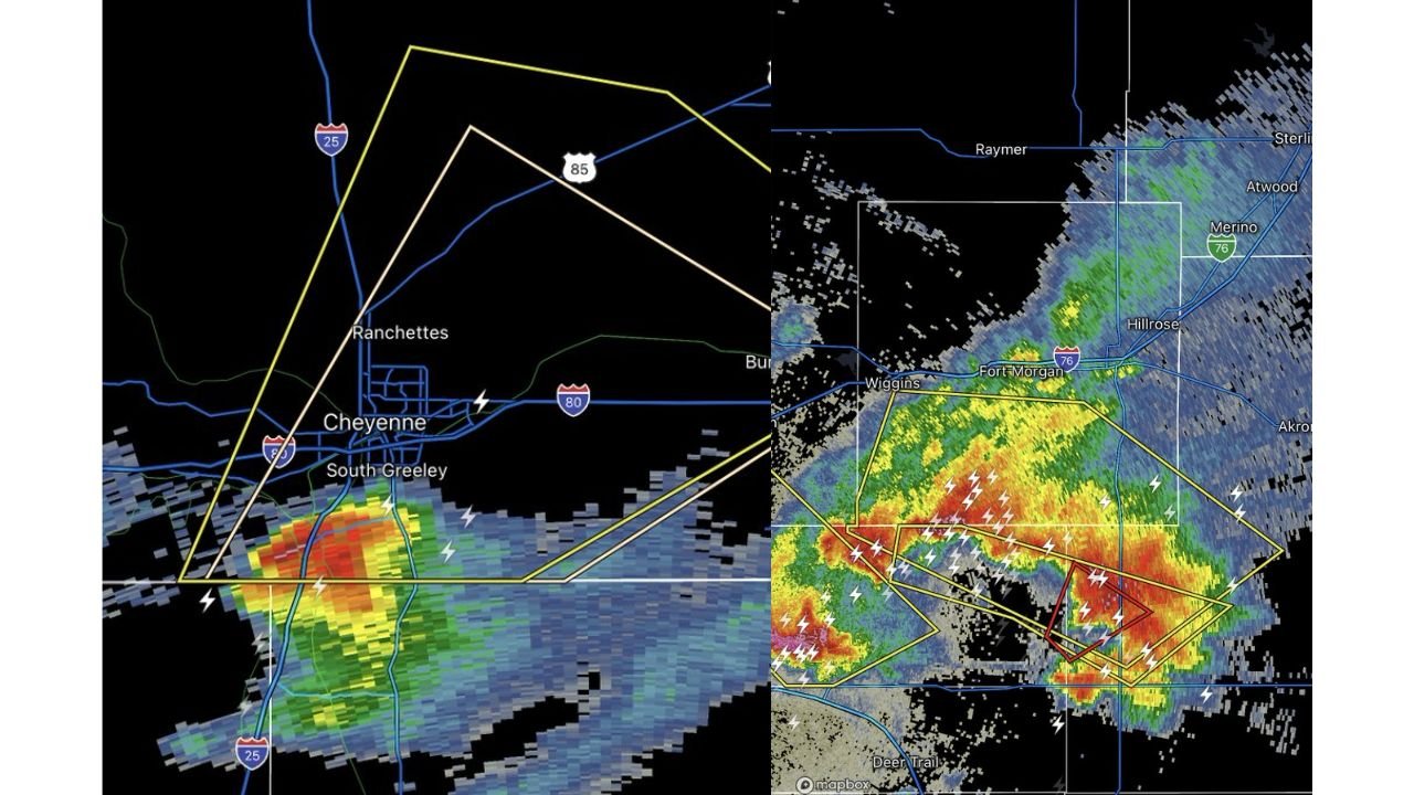
The Cheyenne Storm: Quarter Size Hail and 60 MPH Winds
The northern storm is moving into the Cheyenne, Wyoming area from the south as of this report, placing Cheyenne, Ranchettes and South Greeley directly in its path. This storm is capable of producing quarter size hail, which is approximately 1 inch in diameter and large enough to crack windshields, dent vehicles and cause injury to anyone caught outdoors. Wind gusts up to 60 mph are also possible with this storm, strong enough to down trees, snap power lines and make driving on I-25 and I-80 through the Cheyenne area extremely hazardous.
What Quarter Size Hail Can Do
Quarter size hail is no minor event for residents in Cheyenne and the surrounding Wyoming communities in the storm’s path. At 1 inch in diameter, hailstones of this size fall fast enough to shatter skylights, break windows, strip leaves and small branches from trees and cause significant damage to rooftops in a matter of minutes. Anyone with vehicles parked outdoors in Cheyenne, Ranchettes or South Greeley should move them under cover immediately if possible.
The Southern Colorado Storm Line: Golf Ball Hail and 60 MPH Winds From Wiggins to Akron
The more extensive and more dangerous storm system is the line of severe thunderstorms stretching from just south of Wiggins to just south of Akron, Colorado, currently moving north-northeast toward the Highway 34 and I-76 corridors. This line of storms is capable of producing hail up to golf ball size, which is approximately 1.75 inches in diameter and one of the most destructive common hail sizes seen in Colorado. Wind gusts up to 60 mph accompany this line, making the combination of impacts severe enough to cause major property damage across a wide swath of northeastern Colorado.
Cities in the Path of the Southern Colorado Storm Line
The following communities are in or immediately ahead of the storm line moving north-northeast toward the Highway 34 and I-76 corridors:
- Wiggins, Colorado sits at the southern anchor of the active storm line as of this report, with the squall line stretching from just south of Wiggins northward toward Akron and producing golf ball size hail and 60 mph gusts along its entire length.
- Fort Morgan, Colorado lies directly along the I-76 corridor in the northward path of the southern storm line, placing this community at direct risk from golf ball size hail and 60 mph wind gusts as the system pushes north-northeast.
- Hillrose and Merino, Colorado are visible on radar along and near the I-76 corridor in the path of the advancing storm system and should take shelter immediately.
- Akron, Colorado sits at the northern end of the storm line’s current extent, with the line of severe storms stretching to just south of Akron and moving in the city’s direction along the northeastern Colorado plains.
- Raymer and Atwood, Colorado are visible on radar north of the storm line’s current position and are in the forward path as the system tracks north-northeast.
- Sterling, Colorado is visible on radar to the northeast and should monitor conditions closely as the storm line continues its north-northeast movement along the I-76 corridor.
- Deer Trail, Colorado is visible to the southwest on radar and falls within the broader severe weather environment associated with the southern storm line on Tuesday, June 2, 2026.
The Highway 34 and I-76 Corridors Are Primary Targets
Both Highway 34 and I-76 in northeastern Colorado are directly in the path of the southern storm line as it moves north-northeast. Driving on either corridor right now is extremely dangerous with 60 mph wind gusts and golf ball size hail capable of striking at any moment. Pull off the road immediately, do not shelter under an overpass, and wait out the storm in the lowest area of a sturdy building before resuming travel on Highway 34 or I-76.
What to Do Right Now in Both States
If you are in Cheyenne, Wyoming or anywhere along the Wiggins to Akron, Colorado storm line corridor, move indoors immediately and stay away from windows. Golf ball size hail at 1.75 inches and 60 mph wind gusts are life-threatening to anyone caught outdoors. Stay sheltered until the storms fully pass and local authorities confirm it is safe to go outside.
WaldronNews.com will continue tracking both active severe storm systems across Cheyenne, Wyoming and the Wiggins to Akron, Colorado corridor along the Highway 34 and I-76 corridors and will provide updates as golf ball size hail, 60 mph wind gusts and storm movement on Tuesday, June 2, 2026 develop.