
Oklahoma Winter Storm Threat: Thursday Morning Commute to Bring Heavy Snow, Ice, and Freezing Drizzle Hazards
Oklahoma — Forecasters are warning of a messy Thursday morning commute across much of Oklahoma, as a surge of cold, moist air sets the stage for moderate to heavy snow, ice, and freezing drizzle. The winter system will move in overnight, making roads slick and visibility poor during the early morning rush hours.
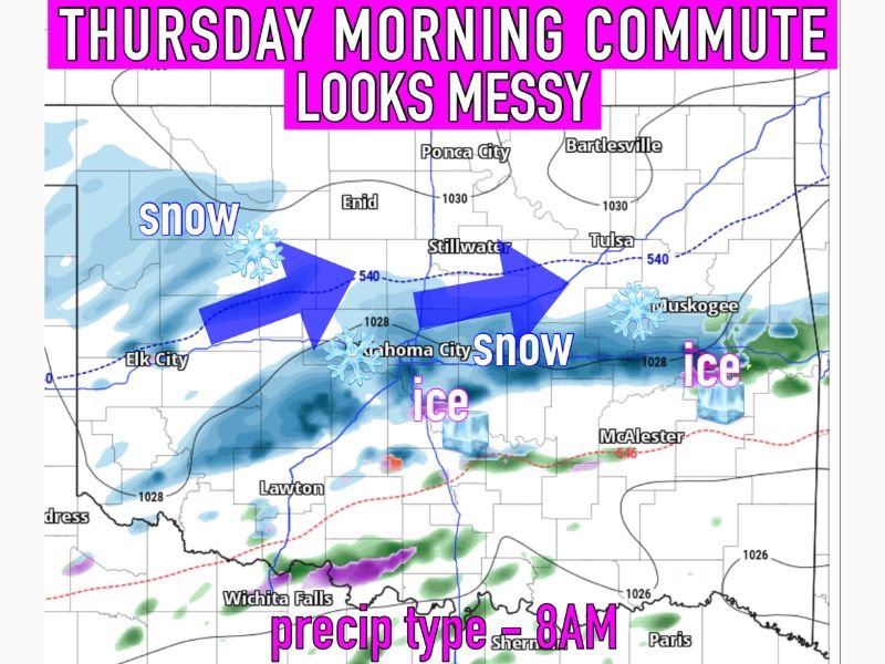
Heavy Snow Bands Expected in Central Oklahoma
Snowfall is expected to intensify early Thursday morning, particularly from Elk City through Oklahoma City and Stillwater. Meteorologists indicate that this zone will experience the heaviest snow bands, with accumulations likely to impact major highways, interstates, and secondary roads.
By 8 a.m., widespread snow will be ongoing across the state’s central corridor, creating low visibility and slippery surfaces for commuters.
Ice Threat Expands Toward Tulsa and Muskogee
Further east, cities such as Tulsa, Muskogee, and McAlester are expected to see patches of ice and freezing drizzle, developing both late tonight and into Thursday morning. Even small amounts of ice can create treacherous travel, especially on bridges, overpasses, and untreated rural routes.
Green Country, in particular, will likely face freezing drizzle off and on overnight, adding another layer of concern for early travelers.
Travel Impacts and Safety Reminders
Officials urge drivers to allow extra travel time, slow down, and keep a safe distance between vehicles. Commuters are also advised to check for school delays or closures in their area, as conditions may worsen through mid-morning.
Residents should monitor local forecasts and be cautious of slick walkways and parking lots, as ice and compacted snow can persist even after precipitation ends.
Cold Air Holds Firm Behind the System
Behind the snow and ice, colder air will remain locked in place across Oklahoma and neighboring states. Temperatures are expected to stay below freezing for much of the day, preventing quick melting and extending travel impacts into Thursday afternoon.
Wind chills may drop further overnight, signaling the arrival of a prolonged cold stretch for the region heading into the weekend.
Drivers are urged to stay weather-aware and follow WaldronNews.com for continuous updates on this developing winter storm, travel advisories, and local safety information.