
Southeast Texas Braces for Late-Night Thunderstorms With Hail, Heavy Rain, and Frequent Lightning
HOUSTON, TEXAS — Residents across southeast Texas, including Houston, League City, and Galveston, should prepare for an active round of thunderstorms late tonight as a low-end severe weather threat moves through the region. While widespread severe weather is not expected, a few storms may become strong enough to produce hail, gusty winds, and frequent lightning.
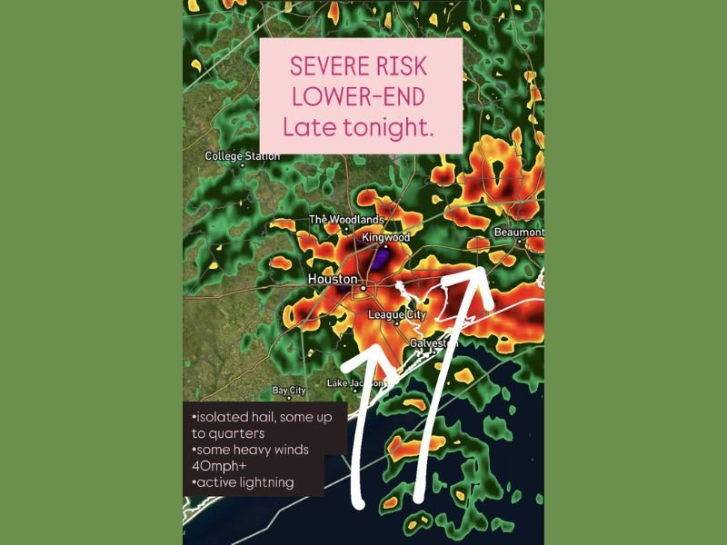
According to the latest radar analysis, a cluster of storms is forming west of the Houston metro area and is expected to move eastward into Harris, Montgomery, and Galveston counties through the overnight hours. The National Weather Service reports that isolated cells could become briefly severe, with hail up to the size of quarters and wind gusts exceeding 40 mph.
Lower-End Severe Threat, But Storms Could Still Pack a Punch
Forecasters emphasize that tonight’s storms are categorized as a “lower-end” severe risk, meaning the majority of storms will remain below warning thresholds. However, embedded stronger cells within the storm line could still cause minor wind damage or localized hail accumulation.
The main impacts expected include:
- 🌩️ Frequent lightning, particularly in southern Harris and Galveston counties
- 🌧️ Heavy rain, leading to brief ponding on roadways
- 💨 Wind gusts of 40 mph or higher
- 🧊 Isolated hail, potentially up to quarter size
Meteorologists note that while tornado potential remains very low, the combination of wind and lightning will make outdoor activity unsafe during peak storm hours.
Storm Timing and Affected Areas
Storms are expected to intensify after 9 p.m. and persist through the early morning hours of Thursday, with the strongest activity likely between 10 p.m. and 2 a.m. The heaviest concentration of storms is forecast to pass over:
- Houston and The Woodlands
- Kingwood and League City
- Beaumont and Galveston
Radar imagery shows significant storm cells stretching from College Station to Bay City, all tracking east-northeast along the Gulf Coast corridor.
Lightning and Hail Among Top Hazards
Residents should be prepared for intense lightning displays, which could cause sporadic power interruptions or minor electrical surges. Outdoor pets and vehicles should be sheltered where possible due to the threat of small hail and wind-driven rain.
Meteorologists also caution drivers to avoid flooded intersections or low-lying roads if downpours become heavy overnight. The combination of darkness, rainfall, and lightning flashes can reduce visibility dramatically.
Looking Ahead
By Thursday morning, the storms are expected to move east toward Louisiana, leaving behind cloudy skies and slightly cooler temperatures. Drier air will settle in across much of southeast Texas by the afternoon, providing a temporary break before the next system arrives later this weekend.
Although tonight’s storms are not forecast to produce widespread damage, forecasters stress the importance of staying alert for weather updates and turning on emergency alerts in case of any local warnings.
For ongoing storm coverage and regional weather alerts, visit waldronnews.com.