
Gulf Coast Braces for Heavy Rain and Thunderstorms as Moisture Surges Inland from the Gulf of Mexico
Biloxi, Mississippi — A powerful surge of Gulf moisture is pushing toward the southern United States tonight, setting up a widespread zone of heavy rain, thunderstorms, and localized flooding from southeast Texas to the Florida Panhandle. Forecasters say the system could dump 1 to 3 inches of rain in some areas, with isolated heavier pockets closer to the coastline.
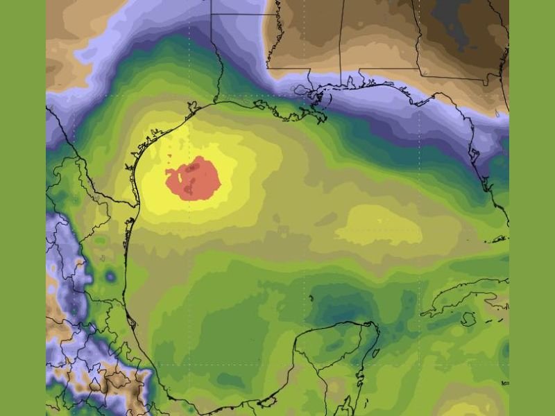
Moisture Plume Targets the Gulf Coast
Weather models show a concentrated area of high atmospheric moisture gathering in the central Gulf of Mexico, moving northward across coastal regions late Wednesday into Thursday. This setup is expected to fuel an extended period of rain and embedded thunderstorms over Louisiana, Mississippi, and southern Alabama overnight.
According to meteorologists, the mass of warm, moisture-laden air will act like a “firehose” aimed directly at the Gulf Coast, creating ideal conditions for torrential rainfall and strong convective storms. The most intense rainfall is expected near Houston, Lake Charles, Baton Rouge, and Biloxi, spreading eastward into Pensacola and the Florida Panhandle by morning.
Flooding and Travel Disruptions Possible
While this system is not tropical in nature, it will behave similarly to one — drawing deep tropical moisture northward and keeping rain bands nearly stationary at times.
This could lead to localized flooding, especially in low-lying coastal zones and poorly drained urban areas.
Drivers along Interstate 10 and U.S. Highway 90 should expect slippery roads, ponding water, and reduced visibility through Thursday morning. Rainfall rates could exceed one inch per hour in the heaviest bands, making flash flooding possible in parts of southern Louisiana and coastal Mississippi.
Storm Outlook for Texas Through Florida
In southeast Texas, areas near Galveston and Beaumont are forecast to see showers increasing by late evening, with potential thunderstorms after midnight. The system will then spread east across Louisiana, Mississippi, and Alabama, before moving into northern Florida by Thursday afternoon.
Forecasters say coastal residents should also prepare for gusty onshore winds and minor tidal flooding in exposed areas. The heaviest rain and thunderstorm activity should taper off by late Thursday night as the disturbance moves inland.
Safety and Preparedness
Officials urge residents to monitor weather alerts and avoid driving through flooded roadways. Even shallow water on pavement can make conditions unpredictable and dangerous.
Meteorologists recommend securing outdoor items and checking local forecasts frequently as additional waves of moisture may follow through the weekend.
Stay tuned to WaldronNews.com for continued updates, radar monitoring, and travel advisories as this Gulf storm system moves across the southern United States.