
Oklahoma City Braces for Thursday Morning Snow as Narrow Band Targets Metro Area
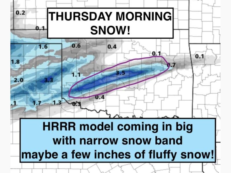
Oklahoma City, Oklahoma — A fresh round of winter weather is on the way for the Oklahoma City metro area, with forecasters monitoring a narrow but potent band of snow expected to arrive early Thursday morning. The latest HRRR weather model suggests that several areas could see a few inches of fluffy snow just in time for the morning rush hour.
Narrow Snow Band Taking Aim at Central Oklahoma
Meteorologists say the setup resembles a classic southern Plains snow event, where a focused line of heavier precipitation develops and drops significant snow in a limited zone. The newest model runs show this narrow band forming in southwest Oklahoma overnight before shifting northeast toward Oklahoma City and surrounding communities.
If the model holds, the metro area could experience 1 to 3 inches of accumulation, with localized totals possibly a bit higher. However, forecasters caution that small shifts in the snow band’s position could significantly affect where the heaviest snow falls.
Timing and Expected Impacts
Snow is expected to begin during the pre-dawn hours Thursday, continuing through the early morning commute. The timing could lead to slick roads, reduced visibility, and delays across major travel corridors, including Interstate 35, Interstate 40, and Interstate 44.
Even though the snow may be light and fluffy, cold surface temperatures will allow it to accumulate quickly on untreated roads and elevated surfaces. Drivers should give themselves extra time and reduce speeds during the morning rush.
Forecast Confidence and Conditions
While the most likely scenario calls for light to moderate snow, the HRRR model shows a realistic potential for a more concentrated burst of heavier snowfall within the main band. This could temporarily create whiteout-like conditions in narrow zones.
Meteorologists describe the setup as “a reasonable upside” event — one that could surprise parts of central Oklahoma with a quick accumulation before tapering off by midday.
Looking Ahead
After the snow moves out Thursday afternoon, skies will begin to clear but temperatures will remain cold, staying below freezing through the day. Any snow on roadways may refreeze Thursday night, creating additional hazards for the Friday morning commute.
Residents are encouraged to monitor weather alerts overnight and check local forecasts for the latest radar updates as the snow band’s path becomes more defined.
Stay with WaldronNews.com for real-time coverage, forecast adjustments, and road condition updates across Oklahoma and the southern Plains as Thursday’s winter system unfolds.