
After This Weekend’s Severe Storm Outbreak, Forecast Signals Hint at Another Late-Month Severe Weather Window Across the Central and Southern U.S.
UNITED STATES — As a multi-day severe weather stretch unfolds across parts of the Southern Plains and Gulf Coast, longer-range guidance is beginning to hint at what could follow once this three-day event winds down.
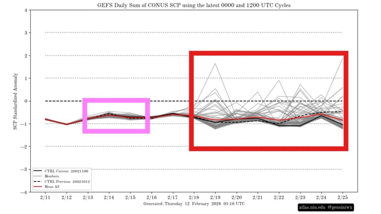
New ensemble data from the GEFS (Global Ensemble Forecast System) tracking the daily sum of CONUS Significant Tornado Parameter (SCP) suggests two distinct phases: the current severe setup — and a potentially more volatile window emerging late next week.
The Pink Box: Ongoing Severe Signal
The highlighted “pink box” period on the chart corresponds to the current three-day severe weather stretch.
During this timeframe:
- SCP values rise modestly compared to earlier in the month
- Ensemble members cluster relatively tightly
- Signals point to organized severe potential rather than widespread extreme outbreaks
This aligns with the current forecast pattern featuring:
- Clusters and lines of storms
- Large hail and damaging wind threats
- Isolated tornado potential
The signal is present, but not extraordinarily amplified on a national scale.
The Red Box: Late-Month Uncertainty and Potential
The larger red-boxed area — covering roughly February 18 through February 25 — shows a sharp increase in spread among ensemble members.
Key observations from the data:
- Several ensemble members spike sharply above average SCP
- A few outliers show notable upward surges
- The mean remains near or slightly below average initially
- Variability grows significantly toward February 24–25
This wide spread indicates high uncertainty — but also potential.
In ensemble forecasting, expanding spread often signals an evolving pattern that could favor stronger dynamics, especially if upper-level troughing deepens over the western or central U.S.
What This Means Meteorologically
When SCP (Significant Tornado Parameter) increases in ensemble projections, it typically reflects:
- Stronger wind shear
- Increasing instability
- Favorable low-level moisture return
- Enhanced storm-scale rotation potential
While it is far too early to pinpoint specific regions, late-month signals often correlate with setups across:
- The Southern Plains
- The Lower Mississippi Valley
- Parts of the Southeast
However, at this range, the data highlights pattern potential — not specific outbreak certainty.
Why Ensemble Spread Matters
The red-box period does not guarantee another severe outbreak. Instead, it tells forecasters:
- The pattern is becoming more dynamic
- Confidence in exact outcomes is low
- Some ensemble solutions favor a stronger severe environment
If more ensemble members begin clustering toward higher SCP values over the coming days, confidence in another severe window would increase.
If the spikes diminish or flatten, the threat may ease.
What Happens After This Weekend?
Once the current severe stretch ends, there may be a brief lull before the pattern reloads.
The key factors to watch include:
- Western U.S. trough development
- Gulf moisture return
- Jet stream positioning
- Timing of surface lows
These ingredients will determine whether the late-month red-box signal materializes into organized severe weather.
Bottom Line
This weekend’s severe weather event is only part of the story.
Long-range ensemble guidance suggests the atmosphere may not fully settle down afterward. While confidence remains low at this range, late February could feature another window where severe weather parameters trend upward.
For now, the focus remains on the current three-day stretch. But the broader pattern bears watching as we move deeper into the month.
WaldronNews.com will continue analyzing ensemble trends and update readers if the late-month severe signal strengthens or shifts in the coming days.