
Alabama and Deep South Communities Told to Watch Growing Drought Risk as New Forecast Signals Dry and Hot Pattern Ahead
ALABAMA — A developing weather pattern is raising serious drought concerns across Alabama and the Deep South, as new data shows rainfall chances dropping sharply over the next 7 to 10 days, despite recent light precipitation in some areas.
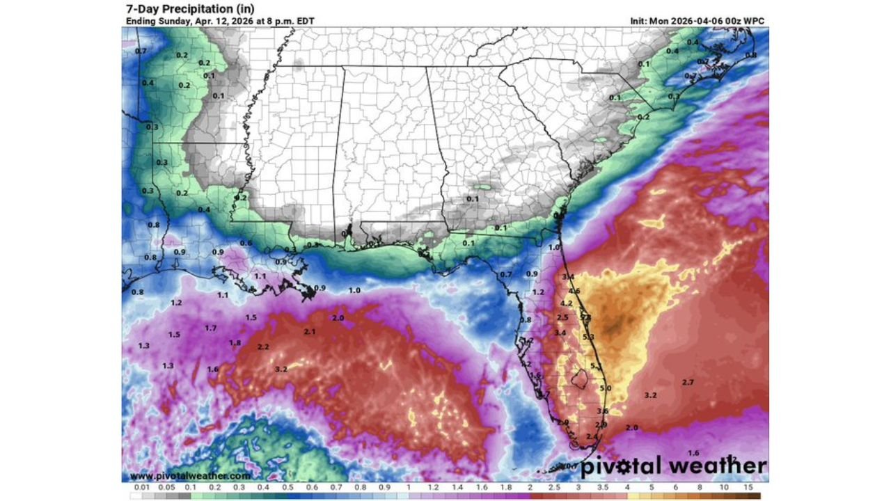
While parts of Alabama received around 0.5 to 1 inch of rain in the past 24 hours, this brief relief is not enough to offset a much larger concern — a rapidly strengthening dry pattern that could dominate through mid-April and beyond.
Nearly 77 Percent of Alabama Already Facing Drought Conditions
The latest drought data shows that approximately 77 percent of Alabama is currently experiencing some level of drought, ranging from abnormally dry to severe drought conditions.
The hardest-hit regions are located in:
- Southern Alabama
- Southeastern counties
- Pockets of central Alabama
These areas are already showing deepening moisture deficits, and without consistent rainfall, conditions are expected to worsen quickly.
This is especially concerning because spring is typically a wetter period, meaning the current dryness is unusual for this time of year.
Rainfall Chances Collapse Over the Next 7 to 10 Days
Forecast guidance clearly indicates that rainfall opportunities will remain very limited in the coming days, with most of Alabama and surrounding states expected to see:
- Minimal precipitation coverage
- Long stretches of dry and stable weather
- Reduced storm development due to atmospheric suppression
This lack of rain is occurring at a time when the region usually benefits from frequent storm systems, making the deficit more impactful.
Strong Upper Ridge Driving Heat and Dry Air
A key factor behind this pattern is the development of a strong upper-level ridge, which is expected to dominate the Southeast through mid-April.
This ridge is responsible for:
- Suppressing cloud formation and rainfall
- Increasing sunshine and daytime heating
- Allowing dry air to persist across the region
As a result, temperatures are also trending higher, with forecasts showing above-normal temperatures across Alabama and much of the Southeast.
The combination of heat plus lack of rainfall is a major driver of rapid drought intensification.
Temperature Outlook Signals Expanding Heat Across the South
Extended outlooks show a widespread area of above-average temperatures covering the Southern United States, including:
- Alabama
- Georgia
- Mississippi
- Florida
- Texas
This indicates a growing risk of:
- Early-season heat stress
- Increased evaporation rates
- Faster soil moisture loss
The longer this pattern persists, the more likely it is that drought conditions will expand and deepen.
Strong El Niño Signal Could Lock in Dry Pattern
One of the most important long-term signals comes from global climate models, which are showing a rapidly strengthening El Niño pattern heading into summer and fall.
Forecast data suggests:
- Sea surface temperature anomalies rising sharply
- A strong El Niño phase becoming established
This matters because El Niño often leads to:
- Reduced tropical storm and hurricane activity in the Atlantic
- A tendency for the Deep South to remain drier than normal
- Fewer opportunities for rain-producing tropical systems
In short, this developing pattern could limit one of the key rainfall sources for the region later in the year.
Why the Next Few Weeks Are Critical
The window between late April and May is now becoming extremely important for Alabama and nearby states.
If meaningful rainfall does not return soon:
- Drought conditions could intensify rapidly
- Summer could begin with significant moisture deficits already in place
- The region could face a long, hot, and dry summer scenario
Entering summer in a drought state is particularly concerning because:
- Rainfall becomes more inconsistent
- Heat becomes more extreme
- Recovery becomes more difficult
What Residents Should Watch Closely
Residents across Alabama and the Deep South should closely monitor:
- Upcoming rain chances in late April
- Changes in the upper-level ridge pattern
- Any signs of storm systems returning to the region
Even a few rounds of steady rainfall could help stabilize conditions, but without that, the trend clearly points toward worsening drought risk.
Stay with WaldronNews.com for continued updates as this developing dry and heat-driven weather pattern evolves across Alabama and the Deep South in the coming weeks.