
Alabama and Mississippi Under Tornado Watch as Severe Storms Bring Risk of Tornadoes, Damaging Winds and Hail
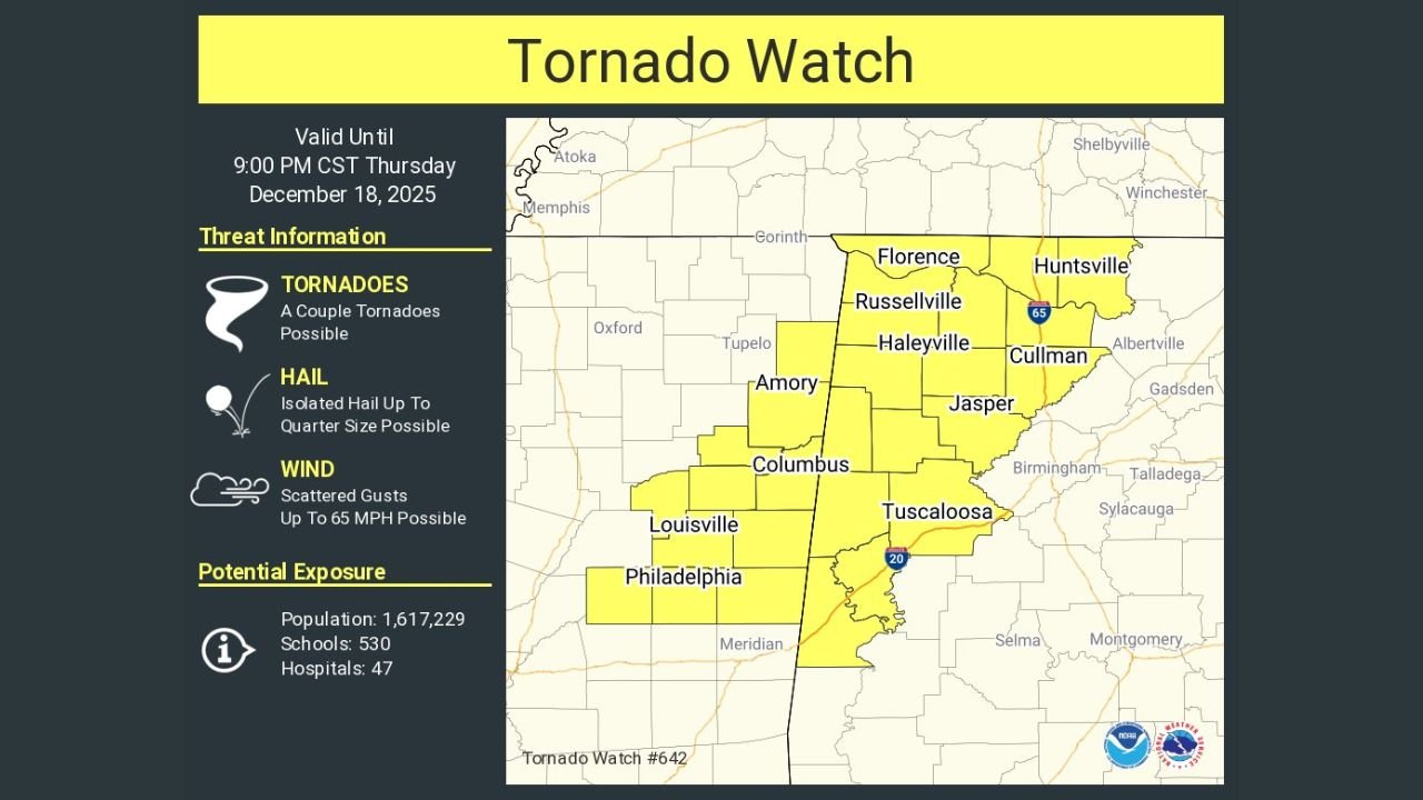
ALABAMA AND MISSISSIPPI — A Tornado Watch has been issued for parts of northern and central Alabama and eastern Mississippi as a strengthening storm system moves through the region. The watch remains in effect until 9:00 PM CST, with forecasters warning that conditions are favorable for a couple of tornadoes, along with damaging winds and isolated hail.
The watch area includes a large portion of north Alabama and eastern Mississippi, covering both urban and rural communities as storms intensify during the evening hours.
Areas Included in the Tornado Watch
According to the watch map, the threat zone spans multiple counties across two states, including communities in:
- Alabama: Florence, Russellville, Haleyville, Huntsville, Cullman, Jasper, Tuscaloosa
- Mississippi: Amory, Columbus, Louisville, Philadelphia
These areas lie within an environment capable of supporting rotating thunderstorms as storms move eastward.
“A couple of tornadoes are possible,” forecasters noted in the official watch information.
Main Threats: Tornadoes, Damaging Winds, and Hail
The Tornado Watch highlights several key hazards expected through the evening:
- Tornadoes: A couple of tornadoes possible
- Wind: Scattered wind gusts up to 65 mph
- Hail: Isolated hail up to quarter size
Even storms that do not produce tornadoes may still cause tree damage, power outages, and hazardous travel due to strong straight-line winds.
Why Conditions Are Favorable for Severe Weather
Meteorologists say the threat is being driven by a strong frontal system interacting with warm, moist air across the region. This setup can allow thunderstorms to organize and rotate, especially during the late afternoon and evening when atmospheric energy is highest.
“This is a classic setup where severe storms can quickly intensify with little warning,” weather officials cautioned.
Population and Infrastructure at Risk
The watch area includes a population of more than 1.6 million people, along with hundreds of schools and dozens of hospitals, underscoring the importance of preparedness and rapid response if warnings are issued.
What Residents Should Do During the Watch
Emergency officials urge residents across the watch area to stay alert:
- Monitor local weather alerts and NOAA Weather Radio
- Have a safe shelter location identified in advance
- Be prepared to act quickly if a Tornado Warning is issued
- Avoid outdoor activities during storms
“A Tornado Watch means be ready to take action,” officials emphasized.
What Happens Next
The Tornado Watch remains in effect until 9 PM CST, though it could be extended or upgraded depending on how storms evolve. If rotation tightens within individual storms, Tornado Warnings may be issued with little notice.
WaldronNews.com will continue monitoring this multi-state severe weather threat affecting Alabama and Mississippi and provide updates as new information becomes available.