
Alabama and the Southeast Face Elevated Tornado Risk on December 18–19 as New Models Highlight Target Areas
ALABAMA — A developing storm system moving across the Southeast is drawing increased attention from forecasters, with Central Alabama emerging as a key area to watch for a possible tornado threat from Thursday into early Friday, December 18–19. New 12Z Day 2 tornado guidance and high-resolution model data suggest conditions could briefly support rotating storms, even though the overall risk remains limited and highly localized.
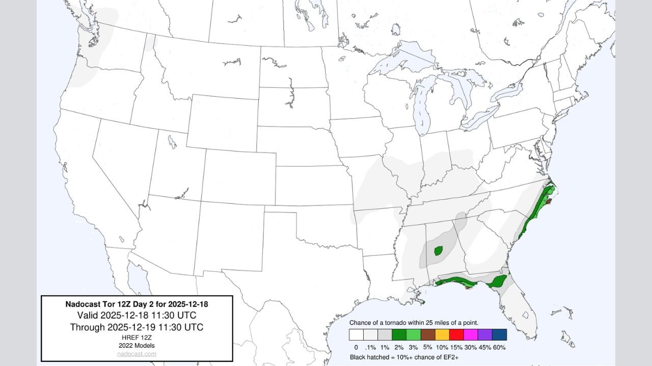
What the New Tornado Forecast Shows
Updated 12Z Day 2 tornado probability maps, based on newer 2022-era model blends, highlight small but notable tornado probabilities across parts of Central Alabama, with additional low-end signals extending into nearby portions of the Gulf Coast and the Southeast.
Forecast guidance indicates:
- Isolated tornado probabilities (2–5%) centered over parts of Central Alabama
- Very low but non-zero signals across southern Mississippi, southwest Georgia, and the Florida Panhandle
- No widespread outbreak signal, but enough overlap to warrant close monitoring
As one meteorologist noted, “I have my eye on Central Alabama for a sleeper tornado threat.”
Why Central Alabama Is the Primary Focus
High-resolution HRRR and ensemble data suggest a narrow window of atmospheric overlap, including:
- Modest low-level wind shear
- Increasing moisture from the Gulf
- Scattered showers and embedded thunderstorms capable of brief rotation
These setups are often referred to as “sleeper” severe weather events, meaning they occur outside classic spring patterns and can catch communities off guard.
Timing: When the Risk Is Highest
Based on the latest model trends:
- Thursday afternoon into Thursday night appears to be the main window of concern
- Some risk may linger into early Friday morning, especially if storms maintain organization overnight
The storms are expected to be fast-moving, which can limit warning lead time.
What This Does Not Appear to Be
Forecasters stress that this setup:
- Is not a widespread tornado outbreak
- Does not show strong long-track tornado signals
- Is highly conditional, depending on storm placement and timing
However, “low probability does not mean zero impact,” especially in December when tornadoes are less expected.
How Residents Should Prepare
Even with a limited risk, residents across Central Alabama are urged to:
- Ensure weather alerts are enabled overnight
- Know where to shelter if warnings are issued
- Stay informed as forecasts evolve
Weather officials emphasize that December tornado events, while uncommon, are historically possible in Alabama, especially during dynamic winter storm systems.
What Happens Next
Meteorologists will continue evaluating:
- Additional HRRR and HREF model runs
- Any updates from the Storm Prediction Center
- Whether tornado probabilities need adjustment later today or overnight
As one forecaster summed it up: “If trends continue, it wouldn’t be surprising to see this risk get more attention.”
Residents are encouraged to stay weather-aware and follow updates as new data becomes available. For continued coverage and local weather updates, keep checking WaldronNews.com.