
Alabama Sees Soaking Rain Event as Narrow Band Delivers 6–10 Inches From Choctaw to Chilton Counties While Southern Areas Miss Out
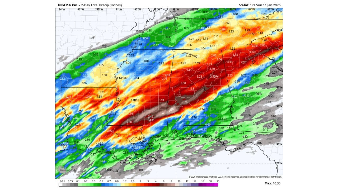
ALABAMA — A powerful rain event over the past two days left parts of central Alabama saturated, with a narrow but intense corridor of heavy rainfall dumping 6 to 10 inches of rain from Silas in Choctaw County through Valley Grande in Dallas County and into Clanton in Chilton County, according to storm-total precipitation data. Areas farther south saw significantly lighter totals, highlighting the sharp gradient in rainfall across the state.
Where the Heaviest Rain Fell
High-resolution precipitation analysis shows the most extreme rainfall focused in a tight southwest-to-northeast band cutting across central Alabama. Communities within this corridor experienced prolonged periods of heavy rain, leading to waterlogged soils and elevated runoff concerns.
Cities and towns near the core of the rainfall axis include:
- Silas (Choctaw County)
- Valley Grande (Dallas County)
- Clanton (Chilton County)
In several locations, totals exceeded 8 inches, with isolated pockets approaching or surpassing 10 inches.
Sharp Drop-Off South of the Core Band
In contrast, southern Alabama saw much lighter precipitation. Many locations south of the main rain axis recorded only a fraction of the totals, underscoring how narrowly focused the heaviest rain was during this event.
This sharp cutoff is typical of strong, moisture-rich storm systems where persistent training of rain bands occurs over the same locations while nearby areas receive much less.
Why This Rainfall Was So Intense
Meteorologists note that the setup favored:
- Repeated rounds of heavy rain over the same counties
- A deep plume of Gulf moisture feeding into the system
- Limited storm movement, allowing rain to accumulate rapidly
These conditions combined to produce exceptionally high storm totals in a short time, especially across central Alabama.
Flooding and Ground Impacts
While widespread river flooding was not immediately reported, the rainfall amounts were sufficient to cause:
- Localized flooding in low-lying and poor-drainage areas
- Standing water on roadways
- Rapid rises in small creeks and streams
With soils now saturated, even additional moderate rain in the coming days could lead to renewed runoff issues.
What Happens Next
As the storm system exits the region, conditions are expected to gradually improve. However, residents in the hardest-hit counties are urged to remain cautious, especially near waterways and during nighttime travel when flooded roads are harder to spot.
Bottom Line
A soaking rain event delivered 6 to 10 inches of rainfall across a narrow stretch of central Alabama, with communities from Silas to Valley Grande to Clanton bearing the brunt of the storm. Meanwhile, southern parts of the state saw far lighter totals, emphasizing how localized this event truly was.
For continued coverage of Alabama weather impacts, rainfall summaries, and what comes next, stay connected with Waldron News and share conditions from your area.