
Alaska, Minnesota, North Dakota and Michigan Could Feel April Impacts as Second Sudden Stratospheric Warming Disrupts Polar Vortex Over the Arctic
ARCTIC CIRCLE — After a major sudden stratospheric warming (SSW) event earlier this month, new forecast guidance now suggests a renewed disruption of the polar vortex around March 26–28, raising fresh questions about how the upper atmosphere could influence April weather patterns across the Northern Hemisphere.
The first SSW event, centered near March 5, marked a significant disturbance in the stratosphere. However, that event did not clearly propagate downward into the troposphere — limiting its longer-term surface impacts.
Now, ensemble model guidance shows another potential wind reversal developing in the upper atmosphere.
What the Data Shows
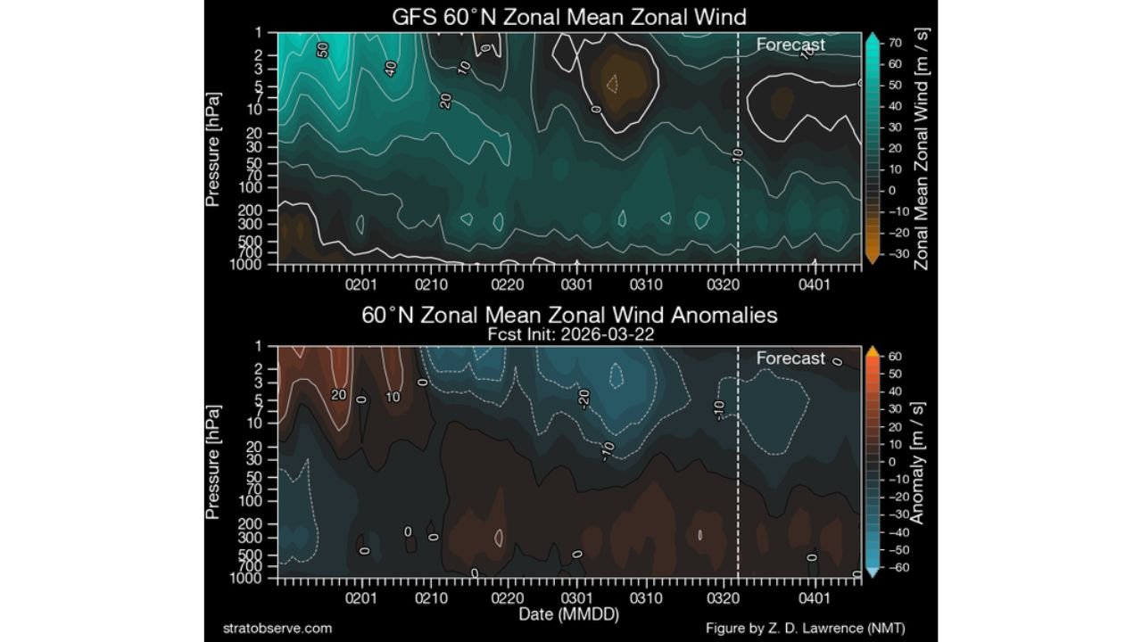
Recent projections of zonal mean zonal wind at 10 hPa (60°N latitude) indicate a steady weakening of stratospheric westerlies heading into late March.
Key signals include:
- Strong westerly winds earlier in March
- Gradual decline through mid to late March
- Ensemble members trending toward near-zero or negative values (easterly anomalies) near March 26–28
When winds at 10 hPa reverse from westerly to easterly, that satisfies one of the defining criteria of a sudden stratospheric warming event.
Why This Event Is Different From Early March
The early March SSW did not show clear downward propagation — meaning the easterly wind anomalies remained largely confined to the stratosphere.
This time, forecast cross-sections of zonal wind anomalies suggest:
- The wind reversal may occur lower in the stratosphere
- There is at least potential for downward extension toward the troposphere
If easterly anomalies propagate downward, the event could have greater influence on surface weather patterns in April.
SSW Classification Rules Matter
To qualify as a separate “midwinter major SSW,” specific conditions must be met:
- Winds must return to westerly for 20 consecutive days between separate events.
- Winds must return to westerly for at least 10 consecutive days before April 30.
If these conditions are not satisfied, the event may be classified as a final warming rather than a distinct major SSW.
These technical distinctions matter for climate cataloging — but from a weather perspective, the key question is whether the disruption reaches the lower atmosphere.
Potential Impacts for April
If downward propagation occurs, it could increase the odds of:
- High-latitude blocking patterns
- Arctic air intrusions into mid-latitudes
- More amplified jet stream patterns
Such configurations sometimes lead to cooler or more volatile spring weather across parts of North America and Europe.
However, forecasters stress that the surface response remains uncertain at this lead time.
Current Outlook
Ensemble guidance continues to trend toward weakening and possible reversal of stratospheric winds at 60°N during the final week of March.
Whether this becomes:
- A renewed major SSW event
- A final seasonal warming
- Or a limited upper-atmosphere disturbance
will depend on how long winds remain reversed and whether anomalies descend into the troposphere.
Bottom Line
A second stratospheric disruption is forecast near March 26–28, potentially weakening the polar vortex again over the Arctic. If the wind reversal propagates downward, April weather patterns across the Northern Hemisphere could become more amplified — but confidence in surface impacts remains limited for now.
Stay with WaldronNews.com for updates as atmospheric signals evolve heading into early spring.