
Alberta Clipper Pattern to Deliver Multiple Rounds of Snow Across Minnesota as Polar Jet Drives Arctic Air Into the U.S.
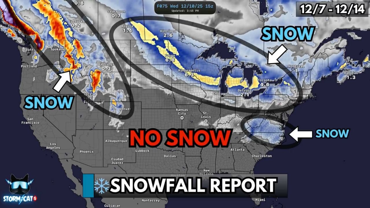
MINNESOTA — A series of fast-moving Alberta Clipper systems will dominate the nation’s weather pattern this week, bringing repeated rounds of accumulating snow, sharp drops in temperature, and bursts of Arctic air sweeping across the Midwest and Great Lakes. Forecasters say this is a classic December Clipper pattern, with Minnesota positioned in one of the most active snow zones.
Below is the full breakdown of what Minnesota and surrounding states can expect through Saturday.
1. Sunday into Monday: First Clip of the Week
A quick-hitting system drops 1 to 4 inches of snow across northern Virginia and North Carolina, but its northern edge brushes the Midwest.
While Minnesota avoids the heaviest totals from this first wave, the system marks the start of the persistent storm train now pointed directly toward the Upper Midwest.
2. Monday Night into Tuesday: Light Snow Returns to Minnesota
A weaker Clipper moves out of Canada and spreads 1 to 2 inches of light snow across central and northern Minnesota.
Forecasters note this wave is not the strongest, but it further primes the region with fresh snowfall and cooler air.
3. Tuesday into Wednesday: Strongest Clipper Targets Minnesota
This is the main event of the week for the Upper Midwest.
A more potent Alberta Clipper is expected to sweep across:
- Minnesota
- Wisconsin
- Michigan
Snowfall forecasts show several inches of accumulation, with some areas receiving 3 to 6+ inches, especially across central and northern Minnesota.
Interior sections of the Northeast will also get several inches as the storm exits, but the core impact zone sits firmly over the Upper Midwest.
Meteorologists highlight this as the strongest and most organized Clipper in the lineup, producing intense but short-lived bursts of moderate to heavy snow.
4. Thursday into Friday: Another Clipper Sweeps Through
A fourth disturbance slides through the Midwest, bringing lighter but widespread snow.
Most Minnesota communities can expect light accumulations, but the concern is ongoing travel impacts due to repeated daily snowfall.
5. Saturday: Final Clipper Brings Additional Accumulating Snow
Yet another Alberta Clipper arrives to close out the week.
While totals are uncertain this far out, forecasters say additional accumulation is likely, especially across northern Minnesota.
A Busy but Not Blockbuster Pattern
Meteorologists emphasize that none of these storms are major blizzards, but the high frequency of Clippers means snow will stack up quickly in favored regions — including Minnesota, Wisconsin, and Michigan.
The Polar Jet Stream remains firmly positioned across the northern U.S., channeling Arctic air and providing the fuel needed for each Clipper to produce fresh snow.
This pattern does not favor the South, where little to no snow is expected.
What Minnesotans Should Expect Overall
- Multiple snow events between Sunday and Saturday
- Frequent, fast-moving bursts of accumulation
- 3 to 6+ inches possible with the strongest Tuesday–Wednesday system
- Very cold air behind each Clipper
- Travel slowdowns likely across interstates and rural highways
Forecasters describe this as a “Clipper-driven December pattern” — one that typically produces consistent light-to-moderate snowfall, ideal for early-season snowpack development.
Stay Prepared
With snow arriving every 24–36 hours, Minnesotans should:
- Keep winter travel kits in vehicles
- Prepare for slower commutes
- Stay updated with National Weather Service alerts
- Expect icy roads, especially during the morning hours
Stay Ahead of the Storm
What do you think about this active winter setup?
Share your thoughts and follow ongoing weather coverage at WaldronNews.com — your source for clear, detailed updates on Minnesota’s fast-changing winter weather.