
Another Severe Weather Threat Building for Friday Across Kansas, Oklahoma, Missouri and Iowa as Cold Front Targets Wichita, Oklahoma City, Kansas City and Des Moines
KANSAS CITY, Missouri — Before the current week’s severe weather outbreak has even finished, another dangerous system is already taking shape on the horizon — as Friday, April 17 emerges as a potential rough severe weather day from the Southern Plains up through the Upper Midwest, with a strong storm system rolling out of the Rockies dragging a cold front through a warm and moisture-rich airmass across a corridor that includes Wichita, Oklahoma City, Tulsa, Kansas City, Des Moines, Omaha, and the Quad Cities.
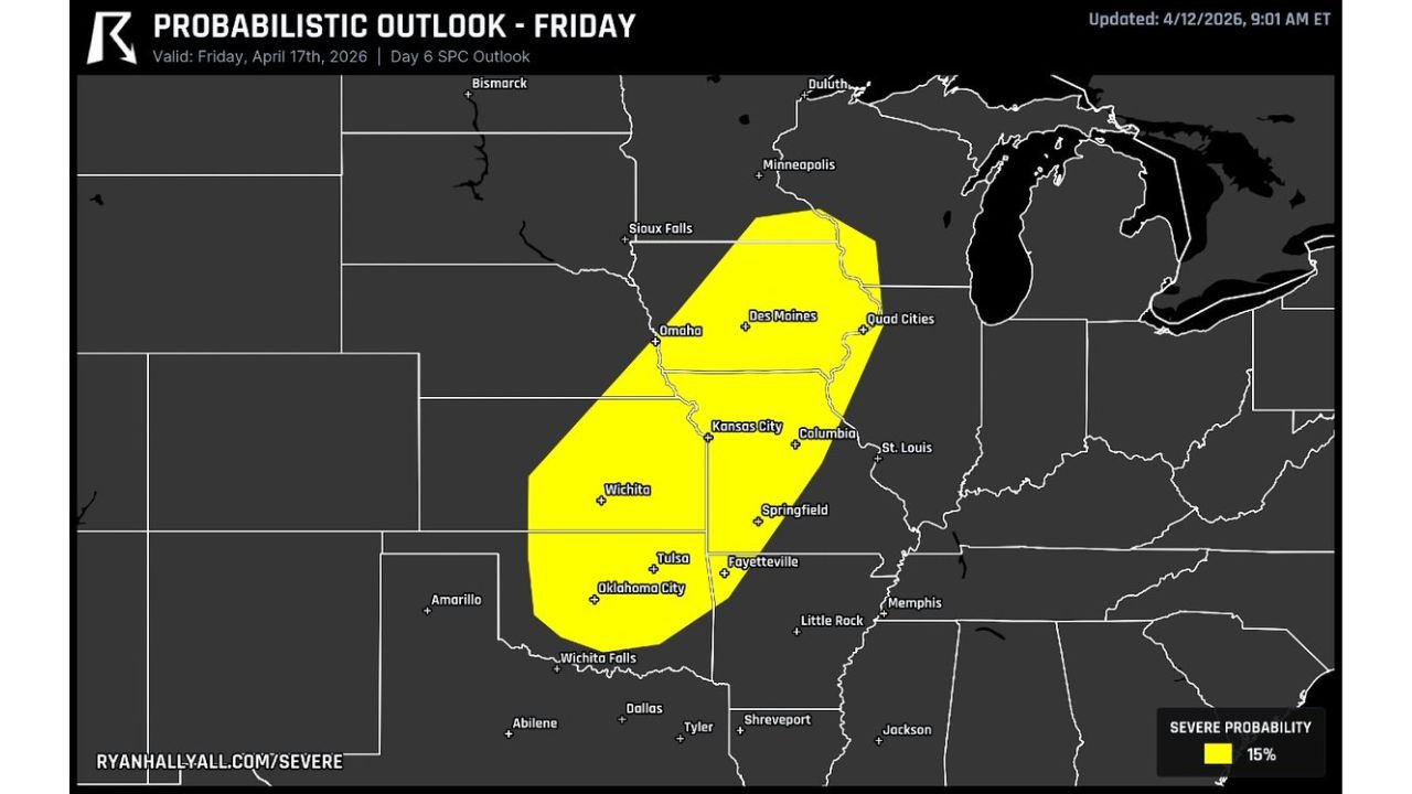
The probabilistic severe weather outlook valid Friday, April 17 — issued as a Day 6 SPC Outlook — already shows a 15% severe weather probability zone covering an enormous swath of the central United States from Wichita Falls, Texas in the south all the way north through Sioux Falls, South Dakota, encompassing some of the most tornado-prone and storm-active real estate in the entire country. Details will shift over the next five days, but the signal is clear and consistent enough to warrant putting Friday firmly on the radar right now.
Cities and States Inside Friday’s 15% Severe Probability Zone
- Oklahoma: Oklahoma City, Tulsa, and Wichita Falls sit at the southern end of the risk corridor — the classic dryline zone where cold front meets warm Gulf airmass
- Kansas: Wichita is squarely inside the risk zone — one of the most frequently targeted cities in any Southern Plains severe weather setup
- Missouri: Kansas City, Columbia, and Springfield fall inside the yellow probability zone as the cold front pushes east through Missouri
- Iowa: Des Moines, the Quad Cities, and Sioux Falls on the northern end of the risk corridor round out the Upper Midwest exposure
- Nebraska: Omaha sits on the northwest boundary of the risk area
- Arkansas: Fayetteville is included on the southeastern edge of the probability zone
What Is Setting This Up
Friday’s severe weather potential is being driven by a textbook cold front severe weather pattern — a strong system rolling out of the Rocky Mountains that drags a cold front eastward through an already warm and moisture-loaded airmass sitting across the central Plains and Midwest. This is one of the most classic and reliable severe weather setups that forecasters see each spring:
The Cold Front Trigger — As the Rocky Mountain storm system pushes east, it forces a sharp cold front into the warm, moist air already in place across Oklahoma, Kansas, Missouri, and Iowa. This frontal boundary is the ignition switch for severe thunderstorm development — wherever the cold front intersects the richest moisture and instability, the most dangerous storms will fire.
Warm and Juicy Airmass — The airmass in place across the central Plains by Friday will have had several days to recover and reload with Gulf moisture following the current week’s storm activity. A reloaded, moisture-rich warm sector beneath an approaching strong upper-level system is precisely the combination that produces widespread severe weather across this corridor.
Classic Setup Recognition — This type of pattern — a strong Rocky Mountain system dragging a cold front through a warm airmass — is the same configuration responsible for many of the most significant severe weather outbreaks in Oklahoma, Kansas, and Missouri history. Forecasters are not treating Friday as a speculative long-range curiosity — they are calling it a rough severe weather day worth tracking immediately.
Why Five Days Out Still Matters
At Day 6 in the forecast cycle, specific details like exact storm timing, the precise track of the highest instability, and the corridor of greatest tornado potential are still subject to meaningful change. However, several aspects of Friday’s setup are already locked in enough to be worth communicating clearly to residents across the risk zone:
The large-scale pattern — a strong trough exiting the Rockies, a cold front, and a loaded warm sector — is consistently showing up across multiple forecast cycles. When a severe weather signal this clear appears at Day 6 and holds through subsequent model runs, it almost always verifies as a significant severe weather day even if individual details shift.
The 15% severe probability zone at Day 6 is not a trivial signal. A 15% probability issued six days out for a corridor this large — covering Oklahoma City through Des Moines — reflects genuine forecaster confidence that a significant severe weather event is likely, not just possible.
Multi-Day Perspective
Friday’s potential outbreak would arrive just three days after Tuesday’s historic instability event across Missouri and Illinois — meaning the central United States is staring at the possibility of severe weather on both ends of the week, with barely a break in between. Residents across Kansas, Oklahoma, Missouri, and Iowa who will be dealing with storm impacts Monday through Wednesday need to be aware that another significant threat may be organizing for the end of the same week.
This kind of back-to-back severe weather pattern is a hallmark of an active spring season, and the atmosphere is showing no signs of calming down through at least the middle of April.
What to Watch as Friday Approaches
- Monitor SPC outlooks daily as Friday gets closer — the Day 6 15% probability zone is expected to be refined and potentially upgraded as confidence increases through Wednesday and Thursday
- The cold front position and speed will be the key variable determining exactly which cities face the worst conditions Friday — watch for NWS updates to sharpen the timing
- Oklahoma City, Tulsa, and Wichita should treat Friday as a preliminary watch day given their position in the southern end of the risk zone where dryline-cold front interactions are most explosive
- Kansas City and Des Moines residents should note that Friday afternoon and evening may bring severe weather just days after Monday and Tuesday’s events — fatigue cannot become complacency
- Keep checking Friday morning forecasts — by Thursday, the details of storm timing, tornado potential, and the exact highest-risk corridor will be significantly clearer
- Anyone with outdoor events planned for Friday across Oklahoma, Kansas, Missouri, or Iowa should have a backup plan and weather monitoring strategy in place before the day arrives
Friday is five days away, but the setup is real and the signal is consistent. From Oklahoma City and Wichita in the south to Des Moines and Sioux Falls in the north, a classic cold front severe weather pattern is targeting the heart of tornado country at the end of this week — and residents across the entire corridor should have it on their radar right now.
WaldronNews.com will continue tracking Friday’s developing severe weather threat across Oklahoma, Kansas, Missouri, Iowa, and the Southern Plains and will provide daily updates as the forecast sharpens heading into the end of the week.