
Arctic Air Blast Set to Grip New York City and the Northeast With Dangerous Wind Chills Near -15°F Through Sunday
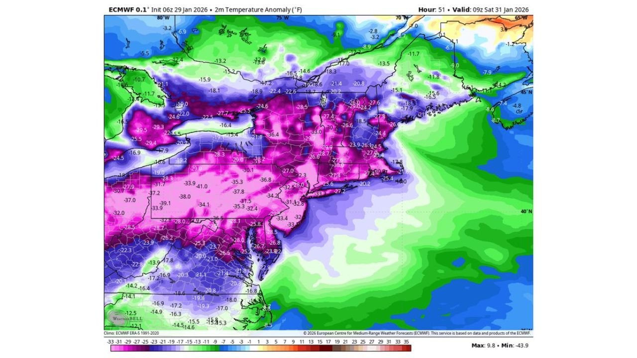
UNITED STATES — A surge of Arctic air is expected to plunge temperatures far below normal across New York City and much of the Northeast beginning Thursday night and lasting through Sunday, according to ECMWF temperature anomaly data showing some of the coldest conditions of the winter season so far.
Forecast guidance indicates temperatures running 25 to more than 35 degrees below average, with wind chill values in parts of the region dropping as low as -15°F, creating potentially dangerous conditions for anyone spending time outdoors.
What the Data Shows: Extreme Temperature Anomalies
The ECMWF model highlights a deep cold core centered over the Mid-Atlantic and Northeast, with the strongest anomalies focused on:
- New York City and surrounding areas
- New Jersey
- Eastern Pennsylvania
- Southern and central New England
Large areas are shaded in dark pink and purple, indicating temperatures 30–40°F colder than normal for late January. These anomalies suggest overnight lows falling into the single digits or below zero, even in urban areas that typically retain heat.
Wind Chill Poses the Greatest Risk
While actual air temperatures will be dangerously cold, strong northwest winds will make conditions feel significantly worse.
Forecast signals suggest:
- Wind chills as low as -10°F to -15°F in New York City and nearby coastal areas
- Even colder apparent temperatures inland, especially across higher elevations
- Increased risk of frostbite within 30 minutes on exposed skin
These conditions are especially hazardous for unhoused populations, outdoor workers, and anyone without adequate heating.
Cold Expected to Persist Through the Weekend
Unlike a brief overnight freeze, this Arctic outbreak is projected to linger through Sunday, with limited daytime warming.
- Daytime highs may struggle to reach the teens or lower 20s
- Overnight temperatures remain well below seasonal norms
- Wind chills may stay below zero for extended periods
The persistence of the cold increases the risk of frozen pipes, heating system strain, and power demand spikes.
Broader Pattern Across the Eastern United States
Although the coldest core is centered on the Northeast, the anomaly map shows below-normal temperatures extending southward into the Mid-Atlantic and parts of the Southeast, signaling a large-scale winter pattern rather than a localized event.
This setup suggests the Arctic air mass is firmly established, making rapid warming unlikely until early next week at the earliest.
What This Means for Arkansas and the South-Central Region
While Arkansas is not expected to experience the same extreme cold shown over the Northeast, the broader pattern confirms continued instability in winter weather across the United States, with sharp temperature contrasts and fast-moving systems remaining possible into early February.
Residents in Arkansas should continue monitoring forecasts, especially as shifts in the jet stream can quickly redirect cold air southward.
Stay with WaldronNews for continued winter weather updates, national pattern breakdowns, and alerts on any changes that could impact Arkansas and the surrounding region.