
Arctic Air Brings Record or Near-Record Cold Across New England, the Mid-Atlantic, and the Deep South as December Lows Shatter Expectations
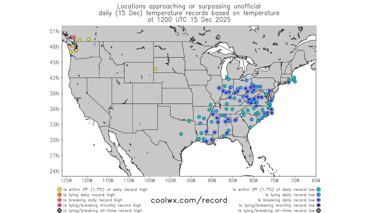
UNITED STATES — A powerful Arctic air mass stretching from New England to the Gulf Coast delivered another morning of record or near-record low temperatures on December 15, impacting a wide swath of the eastern and central United States. Temperature data shows dozens of locations either breaking, tying, or coming within a few degrees of daily cold records, underscoring the unusual reach and persistence of this early-season Arctic outbreak.
According to meteorologist Paul Dorian, the cold air mass spans nearly the entire eastern half of the country, affecting regions unaccustomed to such intense cold this early in December.
New England and the Northeast See Widespread Record-Challenging Lows
One of the most heavily impacted regions is New England, where numerous locations recorded temperatures within three degrees of daily record lows, with some sites tying or breaking records outright.
Data highlights show:
- Multiple stations in Massachusetts, New Hampshire, and Maine reaching near-record cold
- Persistent subfreezing morning temperatures
- Arctic air firmly entrenched across the region
This level of cold in mid-December is well below seasonal norms, reinforcing how anomalous this air mass has been.
Mid-Atlantic and Ohio Valley Also Hit Hard by Arctic Surge
Farther south, the Mid-Atlantic and Ohio Valley experienced some of the most widespread record proximity, with clusters of stations approaching or exceeding unofficial daily records.
Impacted areas include:
- Pennsylvania
- Maryland
- Virginia
- West Virginia
- Ohio
Many locations across these states reported temperatures several degrees below normal, with the cold penetrating deep into valleys and urban corridors that typically moderate overnight lows.
Deep South and Gulf States Feel the Reach of the Arctic Air
Perhaps most notable is how far south the Arctic air extended. Temperature data shows record-challenging lows reaching into the Deep South, including parts of:
- Alabama
- Mississippi
- Georgia
- Louisiana
- Northern Florida
While absolute temperatures were not as low as in northern states, relative departures from normal were significant, enough to place many stations within range of daily records.
This southward reach highlights the depth and strength of the cold core, an uncommon feature for mid-December.
Why This Cold Outbreak Is Unusual
The defining feature of this event is its geographic scale. Rather than being confined to the northern tier, the Arctic air mass expanded from New England all the way to the Gulf Coast, impacting multiple climate zones simultaneously.
Key factors include:
- Strong Arctic high pressure
- A favorable jet stream alignment allowing cold air to spill south
- Minimal moderation overnight due to clear skies and light winds
As noted in the analysis:
“Here we go again with numerous record or near-record lows this morning in an Arctic air mass that extends from New England to the Gulf.”
What Comes Next
While temperatures are expected to moderate in some areas over the coming days, the cold pattern is not finished, and additional intrusions of Arctic air remain possible later this month.
Residents across affected regions are advised to:
- Continue cold-weather precautions
- Protect exposed pipes and sensitive plants
- Check on vulnerable individuals
Early-season Arctic outbreaks like this often signal an active winter pattern, even if brief warm-ups occur in between.
WaldronNews.com will continue tracking record temperatures and Arctic air outbreaks across the United States.
If your community experienced a record low or unusually cold morning, share your local report with WaldronNews.com to help document this widespread December cold event.