
Arctic Air From the North Pole to Slam New York, New England, and the Northeast With Dangerous Subzero Cold This Weekend
UNITED STATES — A powerful Arctic air mass is set to surge into the Northeast this weekend, bringing some of the coldest temperatures of the winter so far to New York City, New England, and surrounding Northeast states, according to GFS model guidance and air-mass trajectory analysis.
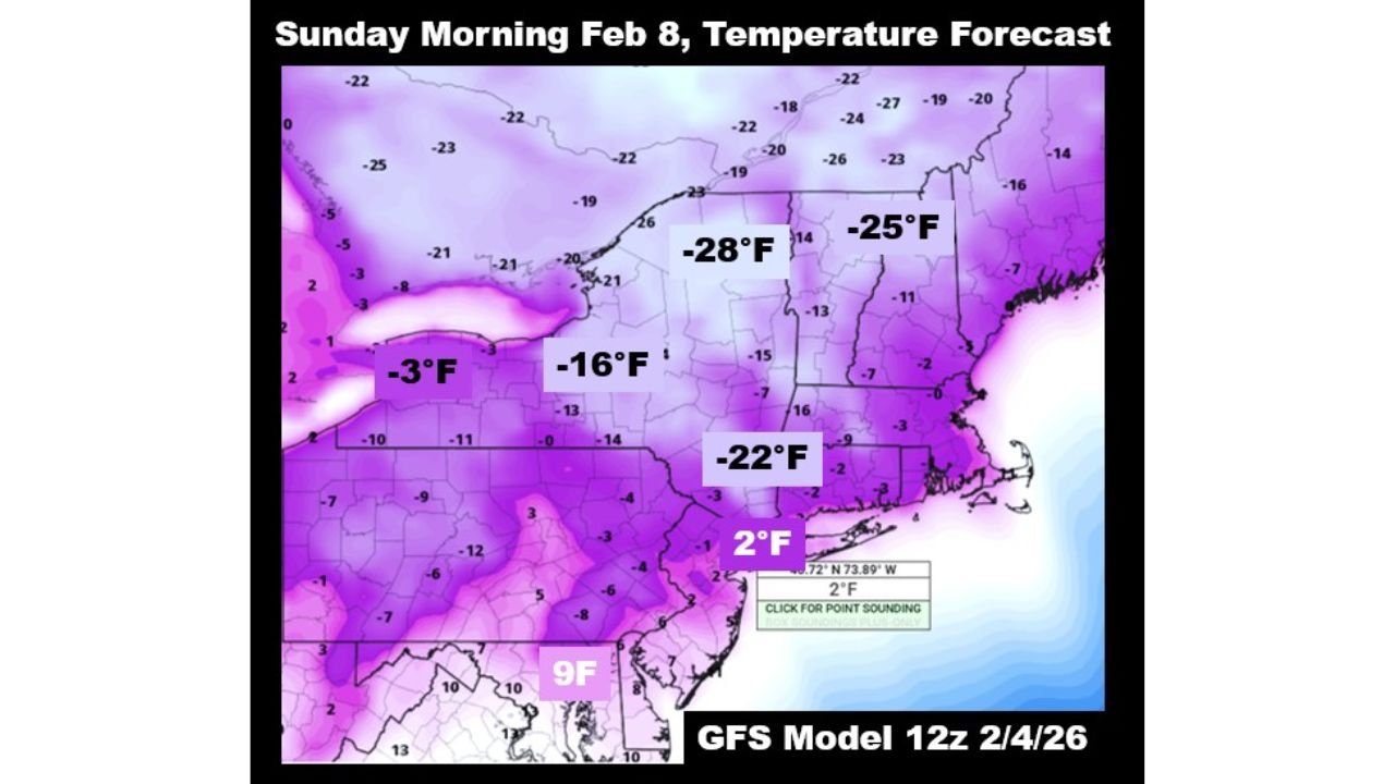
Forecast data shows Sunday morning, February 8, shaping up to be especially dangerous, with subzero temperatures and extreme wind chills spreading across much of the region as air originating near the North Pole plunges southward.
How Cold Will It Get Across the Northeast?
Temperature projections from the GFS 12z model show widespread single digits and deep subzero readings by early Sunday morning.
Expected low temperatures include:
- Interior New England: as cold as -28°F
- Upstate New York: near -25°F
- Northern Pennsylvania and inland Northeast: around -22°F
- Ohio Valley fringe: near -16°F
- Coastal Northeast and NYC metro: low single digits, with dangerous wind chills
Even areas closer to the coast that avoid the worst of the cold will still experience brutally cold conditions rarely seen in recent winters.
Why This Cold Is So Extreme
Backward trajectory data from the NOAA HYSPLIT model shows the incoming air mass tracing directly back to the high Arctic, near the North Pole, over a seven-day period.
This confirms that the cold is not shallow or modified, but instead a deep, unaltered Arctic outbreak, capable of driving temperatures well below seasonal norms.
Meteorologists note that air masses of this origin typically produce:
- Rapid temperature drops
- Minimal daytime recovery
- Increased risk of frostbite and hypothermia
Timing: When Conditions Will Be Worst
- Saturday night: Temperatures begin falling rapidly
- Early Sunday morning (Feb 8): Coldest conditions arrive
- Sunday daytime: Temperatures remain extremely low with little recovery
- Sunday night: Continued dangerous cold before gradual moderation next week
Travel, outdoor activities, and exposed infrastructure will all be impacted during this period.
Safety and Infrastructure Concerns
With temperatures this low, residents across New York, New England, Pennsylvania, and nearby states should prepare for:
- Increased risk of frozen pipes
- Dangerous wind chills
- Strain on heating systems
- Life-threatening exposure in minutes for unprotected skin
Officials urge limiting time outdoors and checking on vulnerable individuals.
What Comes Next
While temperatures are expected to moderate gradually after the weekend, forecasters caution that February remains volatile, and additional Arctic intrusions are still possible later in the month.
This outbreak serves as a reminder that winter’s most dangerous cold can still arrive deep into the season.
Stay Connected
Have you experienced extreme cold like this before in your area? How are you preparing for the weekend freeze?
Share your thoughts and stay updated with the latest weather coverage at WaldronNews.com.