
Arctic Air Over the Southeast Creates Rare ‘Cloud Streets’ as Snow Cover and Ocean Contrast Show Up on Satellite Imagery
UNITED STATES — A striking visible satellite image captured Sunday afternoon reveals how extreme cold air pouring across the Southeast is interacting with snow-covered land and warmer ocean waters, producing long, organized cloud formations known as cloud streets across parts of the Gulf of Mexico and the western Atlantic.
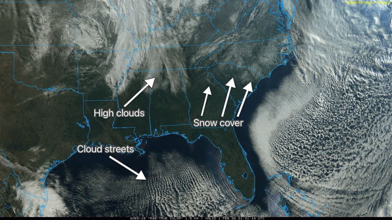
The imagery shows high clouds over North Alabama, widespread snow cover across Northeast Georgia and the Carolinas, and parallel rows of clouds stretching offshore, highlighting the sharp contrast between frigid continental air and much warmer coastal waters.
Why the Satellite Image Looks So Unusual
According to meteorologists, the unusual appearance is the result of very cold, dry Arctic air flowing southward over surfaces with drastically different temperatures.
Snow-covered land reflects sunlight efficiently, making snow fields easily visible from space, while open water in the Gulf and Atlantic remains significantly warmer, allowing heat and moisture to rise rapidly into the atmosphere.
This contrast creates ideal conditions for vertical air motion, where warmer, moist air rises from the ocean surface into the colder air above.
What Are ‘Cloud Streets’?
The long, parallel rows seen offshore are known as cloud streets, a phenomenon that forms when:
- Cold air moves over warmer water
- Heat and moisture rise in narrow columns
- Low-level winds organize those rising columns into long, aligned bands
These cloud bands line up with the wind direction and can extend hundreds of miles, which is clearly visible in the satellite imagery across both the Gulf of Mexico and the Atlantic Ocean.
Snow Cover Enhancing the Temperature Contrast
The image also highlights extensive snow cover across Northeast Georgia and the Carolinas, leftover from recent winter storms.
Snow cover intensifies cold conditions by reflecting solar radiation and limiting surface warming, allowing Arctic air masses to remain stronger for longer periods. This helps maintain the sharp temperature gradient that fuels cloud street development offshore.
What This Tells Meteorologists
While cloud streets themselves are not dangerous, they are a clear signal of an intensely cold air mass in place. Their presence confirms:
- Strong Arctic air advection
- Very cold lower-atmosphere temperatures
- Significant surface-to-air temperature differences
These patterns often accompany dangerously low wind chills, prolonged freezing conditions, and continued winter weather impacts across affected regions.
Cold Pattern Still Dominating the Eastern U.S.
Meteorologists note that this satellite snapshot fits into a broader pattern of persistent cold across much of the eastern United States, with Arctic air masses repeatedly pushing southward and interacting with both land and ocean environments.
As long as cold air remains entrenched and snow cover persists inland, similar satellite features may continue to appear during clear daylight hours.
Residents across the Southeast and surrounding regions are urged to remain weather-aware, continue cold-weather safety precautions, and check on vulnerable neighbors as winter conditions persist.
Have you noticed unusual skies or lingering cold where you live? Share your observations and stay connected with ongoing coverage at WaldronNews.com.