
Arctic Airmass Targets New York, Pennsylvania, New Jersey, and New England With Potential Coldest Day of the Season on Sunday
UNITED STATES — A powerful Arctic air outbreak is setting up across the Northeast, with Sunday emerging as a strong contender for the coldest day of the season so far, according to model-based wind chill and temperature data valid February 8, 2026.
Forecast guidance shows a deep plunge in temperatures across New England, the Mid-Atlantic, and parts of the Great Lakes, driven by a direct surge of polar air originating from far northern latitudes. The result will be dangerous wind chills, sub-zero “feels-like” temperatures, and actual air temperatures running 20 to 30 degrees below normal across a large portion of the region.
Wind Chills Fall Well Below Zero Across Multiple States
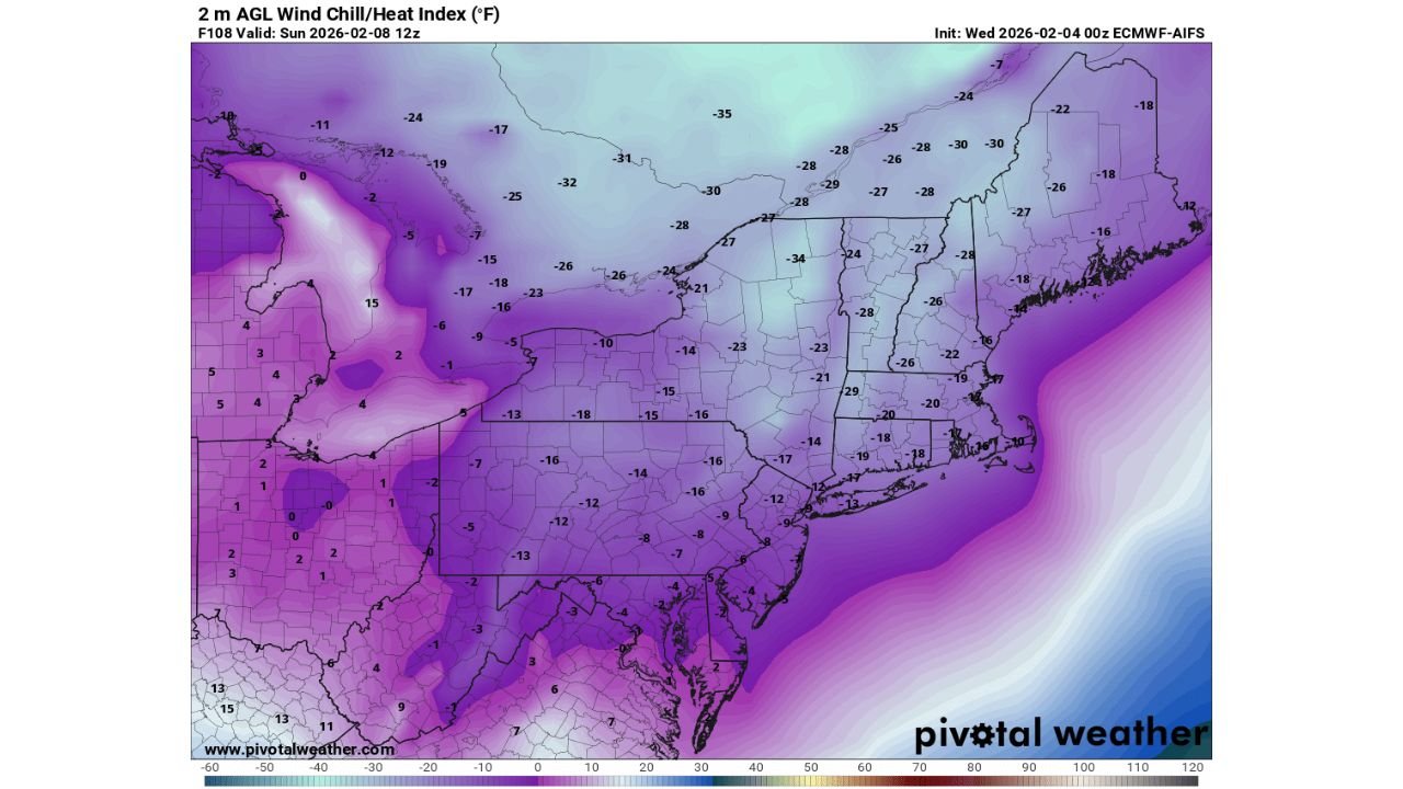
Model wind chill maps indicate widespread sub-zero apparent temperatures across nearly the entire Northeast early Sunday morning.
- Interior New England, including northern New Hampshire and Maine, shows wind chills dropping into the -25°F to -35°F range
- Upstate New York and Vermont are forecast to see wind chills between -20°F and -30°F
- Massachusetts, Connecticut, and Rhode Island fall into the -15°F to -25°F category
- New Jersey, eastern Pennsylvania, and southern New York are projected to experience wind chills from -10°F to -20°F
- Even coastal areas are not spared, with wind chills remaining well below zero despite ocean moderation
These values suggest dangerous cold exposure conditions, especially during early morning hours when winds remain elevated.
Actual Temperatures 20–30 Degrees Below Average
Beyond wind chill, actual surface temperatures also plunge sharply.
Forecast data shows:
- Single digits or below zero across much of New England
- Teens or single digits across the Mid-Atlantic
- Temperatures running 20 to 30 degrees colder than climatological averages for early February
This degree of anomaly confirms the strength of the Arctic air mass and reinforces why Sunday stands out as a likely seasonal low point.
Cold Air Origin Confirms Arctic Source
Trajectory analysis tied to the model guidance indicates the incoming air mass originates from extreme northern latitudes, reinforcing confidence in the severity of the cold.
Air parcels traced backward show movement from far northern regions, consistent with true Arctic outbreaks rather than shallow continental cold. This supports the forecast of persistent cold throughout the day, not just during overnight hours.
Sunday Morning Appears to Be the Coldest Window
The coldest conditions are expected Sunday morning, though wind chills are likely to remain dangerously low through much of the day.
Even as daytime heating attempts to recover temperatures slightly:
- Strong winds continue to reinforce low apparent temperatures
- Many areas remain below zero in wind chill through midday
- Frostbite risk increases rapidly with prolonged exposure
What This Means for Residents
While no single storm system is responsible, the cold itself becomes the primary hazard.
Residents should prepare for:
- Rapid heat loss outdoors
- Increased strain on heating systems
- Elevated risk for vulnerable populations, pets, and exposed infrastructure
Travel may not be snow-impacted everywhere, but cold-related issues could still cause disruptions.
Cold Pattern Not Expected to Last Forever
While the short-term focus remains on Sunday’s extreme cold, longer-range trends suggest moderation may follow later next week, as the Arctic air gradually retreats.
However, confidence remains high that Sunday will be a standout cold day for much of the Northeast before any warming arrives.
Stay Connected
This cold outbreak is evolving, and timing or intensity could still shift slightly with new data. For continued updates, model breakdowns, and regional impact analysis, follow ongoing coverage on WaldronNews.com and check back as conditions develop.