
Arctic Front Could Trigger Rare Ocean-Effect Snow Showers Near Tampa Bay Late Saturday Night, Though Accumulation Is Unlikely
UNITED STATES — Meteorologists are monitoring an unusual post–Arctic front setup that could produce brief snow showers near the Tampa Bay area late Saturday night, driven by ocean-effect precipitation off the Gulf of Mexico as cold winds sweep over unusually warm waters.
While the idea of snow near Tampa is rare, forecasters stress that any snow showers would be light, short-lived, and largely non-accumulating, serving more as a meteorological curiosity than a disruptive winter event.
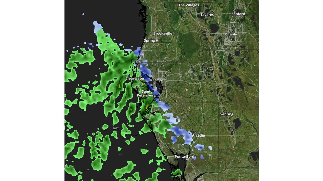
What the Radar Data Shows Near the Gulf Coast
The imagery highlights bands of precipitation developing offshore in the eastern Gulf of Mexico, with:
- Green areas indicating rain showers
- Blue speckling showing pockets where temperatures may be cold enough for snow or mixed precipitation
- Narrow bands aimed toward Clearwater, St. Petersburg, Tampa, and areas south toward Punta Gorda
These bands are forming behind a strong Arctic front, where colder air rapidly moves in from the north.
Why Snow Is Even Possible in West-Central Florida
This setup resembles ocean-effect snow, similar in concept to lake-effect snow in the Great Lakes region.
Key ingredients include:
- Very cold air aloft pouring south behind the Arctic front
- Warm Gulf waters providing moisture and instability
- Persistent onshore or northwest winds directing showers toward the coast
When these elements align, brief snow showers or flurries can develop—even in places that almost never see snow.
Why Accumulation Is Not Expected
Despite the cold air, conditions near the surface remain unfavorable for snow to stick:
- Ground and road temperatures are too warm
- Any flakes would likely melt on contact
- Snow would be spotty and intermittent, not widespread
At most, residents could see brief flakes mixed with rain, especially near the coast.
Areas Most Likely to See Flurries
If snow showers do occur, the most likely locations include:
- Coastal Pinellas County, including Clearwater and St. Petersburg
- Parts of Hillsborough County, including Tampa
- Coastal areas south toward Manatee and Charlotte counties
Inland locations, including Orlando and central Florida, are unlikely to see any snow.
Why This Event Is Still Noteworthy
Snow showers near Tampa are extremely rare, and even the possibility reflects the strength of the Arctic air mass pushing deep into the Southeast.
While impacts are expected to be minimal, the setup highlights just how unusual and dynamic the current winter pattern has become.
What This Means for Arkansas
Although Arkansas is not affected by this specific ocean-effect setup, the same Arctic air responsible for this scenario has already influenced parts of the South-Central U.S.
Strong cold fronts like this one can set the stage for future systems, and residents should continue monitoring changing winter conditions.
Stay with WaldronNews for continued winter weather coverage, rare weather event explanations, and updates on evolving national patterns that could impact Arkansas next.