
Arctic High Pressure to Drive Bitter Cold and Shift Snow Threat South Across the Plains, Ohio Valley, and Mid-Atlantic Through Late January
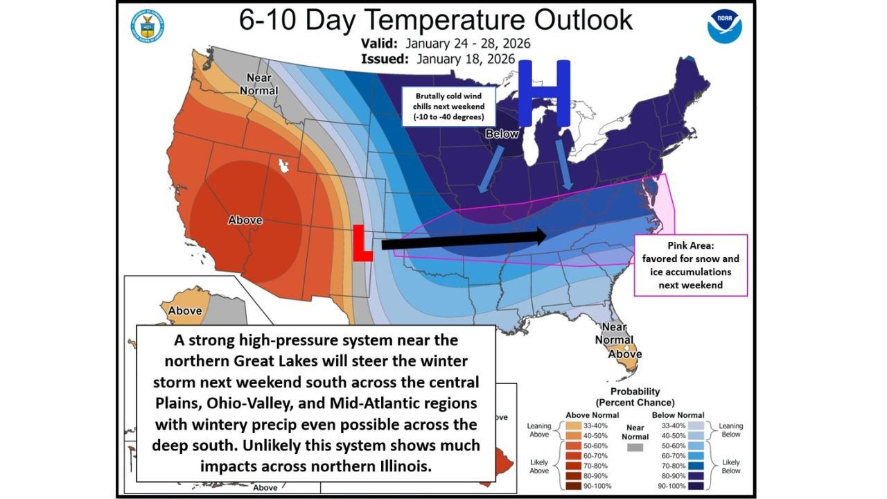
UNITED STATES — A powerful Arctic high-pressure system settling over the northern Great Lakes is set to dominate the weather pattern across much of the eastern half of the country through late January, bringing dangerously cold temperatures to the Midwest while pushing the primary snow and ice threat farther south into the central Plains, Ohio Valley, and Mid-Atlantic regions.
Meteorologists say the strength and placement of this Arctic high will play a critical role in steering storm systems away from northern Illinois and the upper Midwest, while opening the door for wintry precipitation across parts of the central and southern United States between January 24 and January 26.
Arctic High Pressure Locks In Extreme Cold Across the Midwest
Forecast guidance shows an unusually strong Arctic high anchoring itself across the northern Great Lakes and southern Canada, reinforcing a deep trough in the jet stream over the eastern United States.
This setup is expected to deliver very cold air with limited moderation, especially across the Midwest and Great Lakes, where daytime highs may struggle to reach the single digits in some locations. Overnight lows are expected to plunge well below zero in colder pockets.
Wind chills during the peak of the outbreak could fall into the 0 to -30 degree range, with some localized areas potentially experiencing even colder values if winds remain elevated.
The presence of this high pressure significantly reduces the likelihood of meaningful snowfall across northern Illinois and surrounding areas, as the storm track is forced well south of the region.
Jet Stream Pattern Forces Storm Systems Southward
The Arctic high is also expected to act as a blocking mechanism, steering incoming winter storm systems along a more southerly path. Instead of tracking through the Midwest or Great Lakes, developing systems are forecast to move across:
- The central Plains
- The Ohio Valley
- Portions of the Mid-Atlantic
- Possibly into parts of the Deep South
This shift increases the risk of snow and ice accumulation in areas that do not typically experience frequent winter weather of this magnitude.
While northern Illinois remains largely cold and dry under this pattern, regions farther south could see a widespread swath of wintry precipitation, including snow, sleet, and freezing rain.
Snow and Ice Threat Builds From January 24 to January 26
Forecast outlooks highlight a favored corridor for snow and ice stretching from the central Plains eastward through the Ohio Valley and into the Mid-Atlantic states.
Several factors support this risk:
- Cold air remains entrenched to the north
- Moisture is transported northeastward from the Gulf of Mexico
- Storm systems are forced along the southern edge of the Arctic air mass
If this pattern holds, travel disruptions could become a concern across multiple states, particularly where snow and ice overlap during peak travel hours.
Dangerous Travel Conditions Possible in Southern and Mid-Atlantic States
In areas where snow does develop, even modest accumulations could result in hazardous road conditions, especially given temperatures near or below freezing.
Reduced visibility in heavier snow bands and slick road surfaces are likely concerns, particularly during morning and midday hours when precipitation rates may briefly intensify.
Motorists traveling across interstates and major corridors in affected regions should remain alert for rapidly changing conditions and allow extra travel time.
Longer-Range Signals Point to Continued Volatility
Looking beyond the immediate Arctic outbreak, longer-range guidance suggests a brief moderation period near the end of January, followed by another potential surge of colder air during the first week of February.
Climate signals, including a weakening La Niña and a developing El Niño influence, suggest February may not follow a typical warm La Niña pattern. This raises the possibility of continued temperature swings and additional winter weather opportunities heading deeper into the season.
What to Watch Moving Forward
- Continued updates on the placement and strength of the Arctic high
- Storm track adjustments that could shift snow farther north or south
- Wind chill advisories and cold-weather safety concerns
- Travel impacts across the Plains, Ohio Valley, and Mid-Atlantic
Residents across much of the eastern United States should prepare for persistent cold, remain cautious during travel, and stay alert for updated forecasts as this complex winter pattern evolves.
Stay connected with Waldron for ongoing winter weather updates, regional impact breakdowns, and the latest forecast changes as this Arctic pattern continues to unfold.