
Arizona Braces for Potential Record-Breaking Heat as Phoenix Forecast Targets Earliest 100°F Day Since 1988 and Unusually Early 70° Nighttime Lows
ARIZONA — Phoenix could be on the verge of rewriting its climate history next week as forecasters project the possibility of the earliest 100-degree day ever recorded for the year — along with one of the earliest 70-degree low temperatures on record.
According to the latest forecast projections, temperatures in Phoenix may surge past the 100°F mark, something that has happened only once before during the month of March.
A Rare March 100-Degree Benchmark
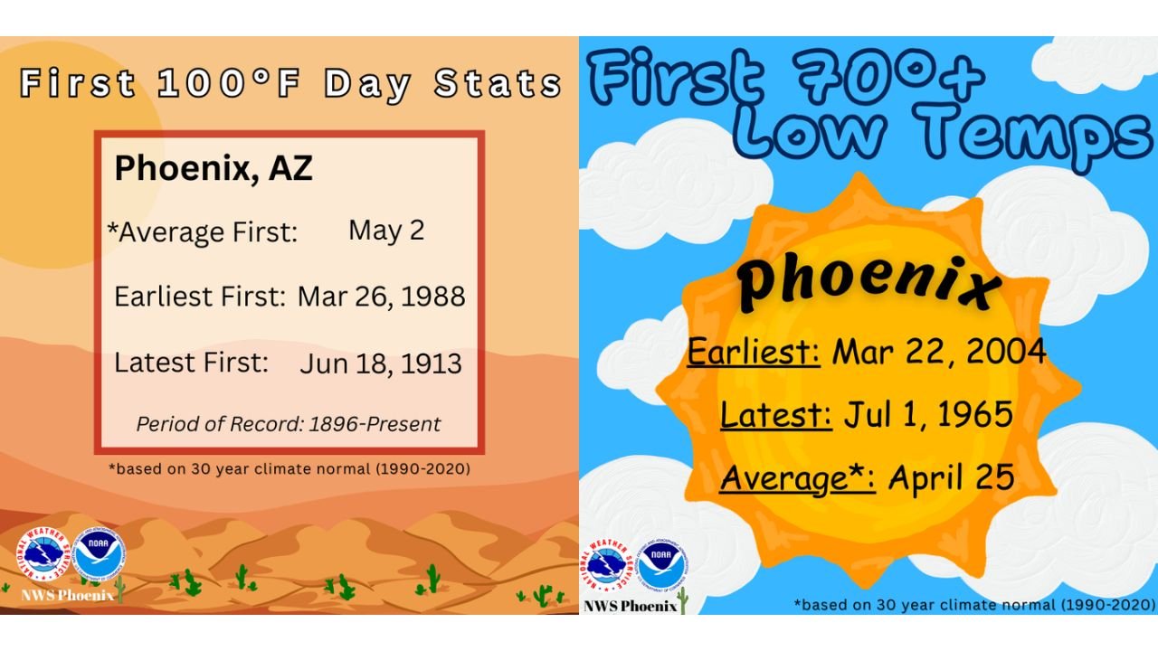
Historical climate statistics for Phoenix show:
- Average first 100°F day: May 2
- Earliest first 100°F day: March 26, 1988
- Latest first 100°F day: June 18, 1913
- Period of record: 1896–Present
If Phoenix reaches 100°F next week, it would challenge — and potentially break — the long-standing March 26, 1988 record for the earliest triple-digit temperature in city history.
That would put this event more than a month ahead of the climatological average, signaling an exceptionally early surge of summer-like heat across the Desert Southwest.
Nights May Stay Unseasonably Warm
The heat may not just be limited to daytime highs. Forecast guidance also suggests the potential for nighttime low temperatures to remain at or above 70 degrees — another unusually early milestone.
Climate records show:
- Average first 70° low: April 25
- Earliest 70° low: March 22, 2004
- Latest first 70° low: July 1, 1965
If Phoenix records a 70-degree low next week, it would rank among the earliest occurrences on record and would come more than a month ahead of the typical seasonal timeline.
What This Means for Arizona
Triple-digit temperatures in March are rare but not unprecedented. However, the combination of:
- A potential 100°F daytime high
- Exceptionally warm overnight lows
- Occurrence weeks before the seasonal average
would mark a significant early-season heat event for Arizona.
Early-season heat can have amplified impacts because residents are often not yet acclimated to summer-like conditions. Cooling demands typically spike, and outdoor activity becomes riskier during peak afternoon hours.
A Strong Signal of a Building Heat Pattern
The forecast setup suggests a strong ridge of high pressure building over the Southwest, allowing dry air and intense sunshine to rapidly heat the lower desert elevations.
When early-season ridging strengthens this aggressively, temperatures can climb quickly — especially in Phoenix’s urban core, where heat retention is enhanced.
If verified, this event would stand alongside the notable March 1988 benchmark in the city’s long climate record.
Residents across Arizona are encouraged to prepare for potentially dangerous heat levels far earlier than normal.
Stay with WaldronNews.com for continued coverage of this developing early-season heat surge.