
Arkansas Christmas Warm-Up Forecast Scaled Back as Long-Range Models Retreat From Earlier Extreme Warmth Projections
ARKANSAS — Forecasts that recently hinted at a dramatic Christmas warm-up across parts of the eastern United States, including Arkansas, are now being scaled back, as updated long-range weather models pull away from earlier projections of prolonged or extreme warmth heading into the holiday period.
Earlier model runs promoted the idea of a strong ridge of warm air developing around December 19–20, with some describing it as a major “pattern change.” As the forecast window has narrowed, those signals have weakened, reducing confidence that Arkansas will experience a sustained warm spell during Christmas week.
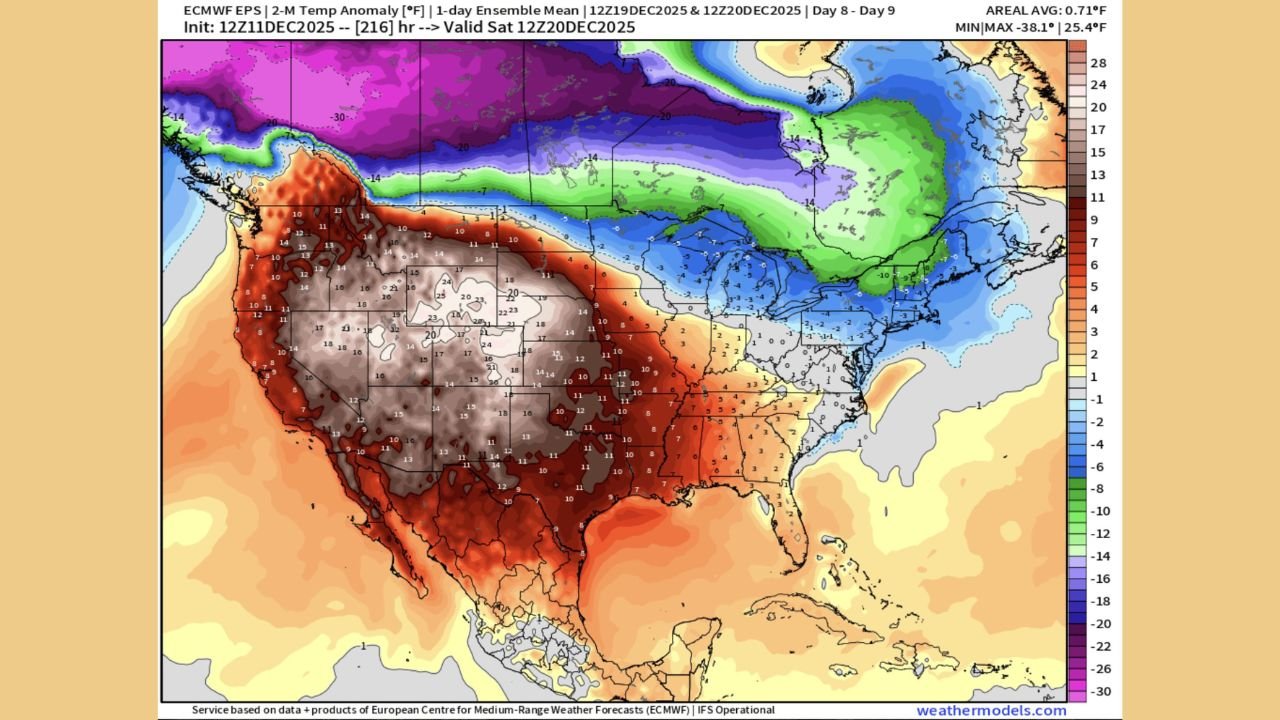
Latest ECMWF Data Shows Warmth Staying West, Cold Holding East
Updated ensemble guidance from the European Centre for Medium-Range Weather Forecasts (ECMWF) shows a markedly different temperature pattern than earlier projections.
The latest temperature anomaly outlook indicates:
- Above-average warmth concentrated across the western and southern United States
- Colder-than-normal air persisting across the Midwest, Great Lakes, and Northeast
- No strong or lasting warm ridge pushing into Arkansas by Christmas
This pattern suggests that while Arkansas could see some relief from early-December cold, the data does not support the idea of a widespread or long-lasting warm-up.
Earlier ‘Blowtorch’ Warmth Signals Continue to Weaken
Forecasts that once advertised a sharp warm-up around December 19–20 have steadily lost support as newer model runs arrive. Instead of strengthening, the warm signal has faded and, in some cases, been pushed farther out toward Christmas Day.
This ongoing shift highlights a common issue in long-range forecasting: extreme temperature scenarios often appear far out, then weaken or disappear as the timeline approaches.
“Kicking the can down the road” has become a recurring theme in late-season temperature outlooks.
Why Long-Range Christmas Forecasts Remain Uncertain
Forecast confidence drops significantly beyond 7 to 10 days, especially during winter. Small changes in jet stream placement, Arctic air intrusions, or upper-level atmospheric patterns can dramatically alter temperature outcomes.
This makes bold claims about prolonged warmth weeks in advance unreliable. Just as early snowstorm forecasts are treated cautiously, extended warm-up projections deserve the same skepticism.
That uncertainty is especially relevant following record or near-record cold earlier this month, when rebound scenarios are often overestimated.
What Arkansas Residents Should Expect Heading Into Christmas
Based on the latest trends:
- A short-lived temperature rebound is possible
- Prolonged or extreme warmth looks increasingly unlikely
- Confidence remains low for Christmas-week temperatures
- Variable winter conditions are more likely than a stable warm pattern
Any warming that does occur is expected to be limited in duration and strength, rather than the dramatic shift earlier forecasts suggested.
Bottom Line for Arkansas Christmas Weather
The newest data shows that earlier hype surrounding a major Arkansas Christmas warm-up is fading, with long-range models steadily retreating from extreme warmth projections as the holiday approaches.
While temperatures may moderate somewhat from recent cold levels, a sustained “blowtorch” warm pattern is becoming less likely with each update.
What do you think — does Arkansas see a mild Christmas, or does winter hold firm? Share your thoughts and stay informed with ongoing local coverage at WaldronNews.com.