
Arkansas Faces Two-Round Rain Pattern This Week as Light Midweek Showers Give Way to Heavier Friday–Saturday System
ARKANSAS — A multi-day rain pattern is setting up across Arkansas this week, beginning with lighter showers midweek before a more widespread and heavier rain event arrives late Friday into Saturday, according to forecast data shown in the latest futurecast and rainfall maps.
The first round of rain is expected late Tuesday into Wednesday, with scattered showers developing across much of the state. Forecast guidance shows this initial system remaining relatively weak, with rainfall totals staying below half an inch for most locations.
Cities including Little Rock, Russellville, Hot Springs, Searcy, Batesville, Fort Smith, Fayetteville, Jonesboro, Pine Bluff, and Texarkana may see periods of light rain, but impacts are expected to be minimal during this phase.
Midweek Rain Remains Limited
Tuesday evening and Wednesday forecasts show narrow bands of rain moving west to east across Arkansas, with some locally heavier pockets possible but no widespread soaking. Rain coverage looks spotty at times, and many areas could experience breaks between showers.
Rainfall totals during this period are expected to remain under 0.50 inches for nearly all of the state, keeping flood concerns low early in the week.
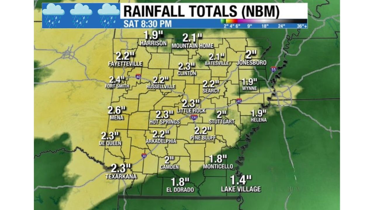
Stronger System Targets Arkansas Late Week
A much more organized weather system is forecast to move into Arkansas late Friday and continue into Saturday. Futurecast imagery shows widespread rain expanding across the state, with heavier bands developing from southwest Arkansas through central and northern regions.
This system is expected to bring 1 to 2 inches of rainfall across most of Arkansas, with locally higher totals possible in spots. Forecast rainfall maps show totals generally ranging from around 1.8 inches to more than 2.5 inches, including:
- Little Rock: around 2.3 inches
- Hot Springs: around 2.3 inches
- Russellville: around 2.2 inches
- Fayetteville: around 2.2 inches
- Fort Smith: around 2.4 inches
- Mena: near 2.6 inches
- Jonesboro: around 2.0 inches
- Batesville: around 2.1 inches
- Texarkana: around 2.3 inches
- Camden and El Dorado: near 1.8 to 2.0 inches
The heaviest rainfall appears most likely from central into northern Arkansas, though much of the state will see measurable rain.
Severe Weather Risk Appears Low for Now
While thunderstorms are possible with the late-week system, current data suggests the overall severe weather risk remains low. A lack of strong instability could limit storm intensity, especially on Saturday, though isolated stronger storms cannot be completely ruled out.
Forecasters will continue monitoring the setup, but at this time the primary concern looks to be beneficial rainfall rather than widespread severe weather.
What Residents Should Expect
Arkansans should prepare for several rounds of rain this week, with the most impactful period coming late Friday into Saturday. While midweek rain should cause little disruption, the late-week system could bring wet travel conditions and localized ponding in areas that see heavier totals.
Despite the rain, the pattern does not currently suggest a high-end severe weather outbreak, making this system more notable for rainfall coverage than storm intensity.
Stay tuned to WaldronNews.com for continued updates as timing and rainfall totals become clearer later this week.