
Arkansas, Louisiana, Texas and Mississippi Highlighted in March 3–10 Severe Storm Surge as Winter Pattern Fades Across Southern Plains
UNITED STATES — The weather pattern across the central United States is shifting, with attention turning away from winter storms and toward an increasingly favorable severe weather setup from March 3 through March 10.
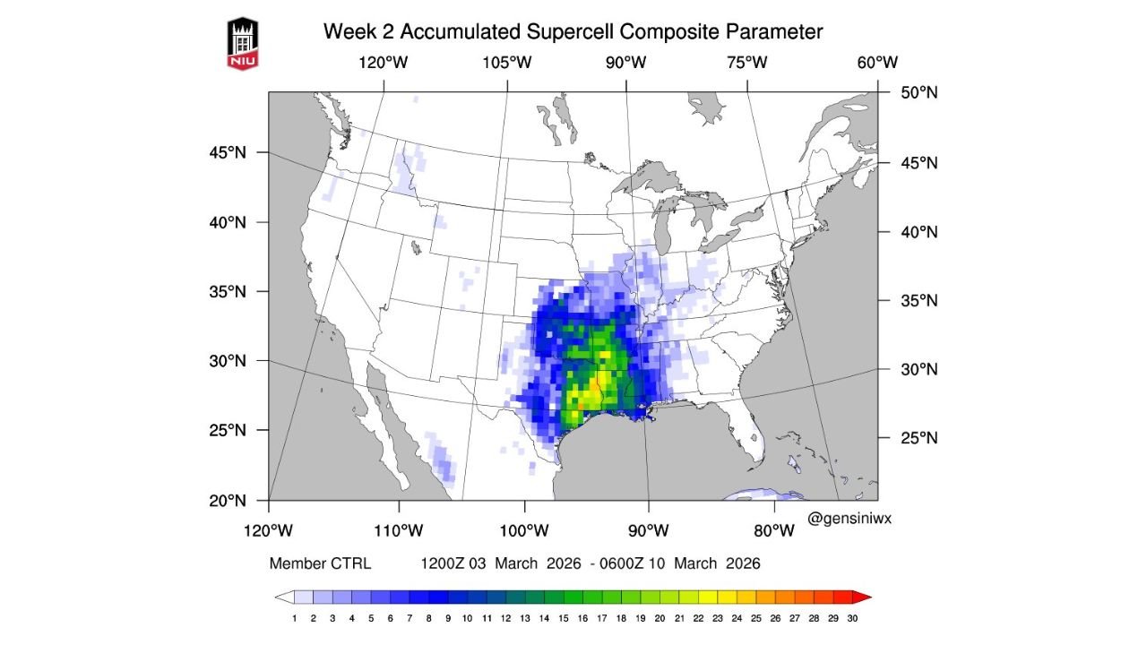
New accumulated supercell composite parameter data for Week 2 shows a concentrated corridor of higher severe storm favorability centered over parts of Arkansas, Louisiana, East Texas and western Mississippi, with surrounding risk extending into Oklahoma and Alabama.
Brighter colors on the map indicate higher potential for organized severe storms during the first half of the month.
Core Area of Concern: Arkansas to Louisiana
The highest concentration of favorable parameters appears focused across:
- Central and southern Arkansas
- Northern and central Louisiana
- East Texas
- Western Mississippi
This corridor is shaded in green to yellow tones — signaling elevated potential for organized thunderstorms, including supercells.
Arkansas stands out in particular, especially notable given the state has recently experienced a relative lull in severe storm reports.
Texas and Mississippi Also in the Zone
The favorable environment expands into:
- Eastern Texas
- Western Mississippi
- Portions of southern Oklahoma
While not every location within the shaded area will see severe weather, the pattern suggests multiple opportunities for storms capable of producing damaging winds, hail, and possibly tornadoes during the March 3–10 window.
Why the Pattern Is Changing
The transition from late-winter systems to early-spring severe setups is common during early March across the Southern Plains and Lower Mississippi Valley.
This shift typically involves:
- Increasing Gulf moisture return
- Strengthening jet stream dynamics
- More frequent frontal boundaries
- Enhanced instability
When these ingredients overlap, the risk for supercells increases.
The composite parameter map reflects a growing overlap of these ingredients across the South-Central United States.
A Drought in Severe Reports May End
Arkansas, in particular, has seen a relative drought in severe weather reports compared to typical early-season climatology.
The projected pattern suggests that drought may not last much longer, as multiple rounds of thunderstorm activity become more likely.
Surrounding States With Lower but Notable Signals
Lighter blue shading extends into:
- Alabama
- Tennessee
- Missouri
- Western Kentucky
While not in the highest-favorability zone, these areas could still see severe storms depending on how individual systems evolve.
What This Means Going Forward
The March 3–10 timeframe does not indicate a single outbreak day — rather, it signals an active pattern with more than one opportunity for severe weather.
Key states to monitor closely:
- Arkansas
- Louisiana
- East Texas
- Western Mississippi
- Southern Oklahoma
As winter systems retreat northward, the Southern Plains and Lower Mississippi Valley may once again become the focal point of severe storm development.
Bottom Line
The focus across the central United States is shifting from snow and ice to thunderstorms and potential severe weather beginning early March.
Arkansas, Louisiana, Texas and Mississippi sit in the highest-favorability corridor for supercells from March 3 through March 10, marking a likely return to active spring weather.
Stay with WaldronNews.com for ongoing severe weather outlooks and detailed regional updates as this evolving pattern takes shape.