
Arkansas, Missouri and Tennessee Face Growing Severe Storm Threat as Squall Line Approaches Little Rock, Memphis and St. Louis
ARKANSAS — Meteorologists are closely monitoring a developing line of thunderstorms that could bring severe weather across Arkansas, Missouri, and western Tennessee, with forecast models suggesting a powerful squall line may sweep across the region by Sunday evening.
New high-resolution weather model simulations indicate a strong band of storms forming from Louisiana through Arkansas into Missouri, with the system moving northeast toward Little Rock, Memphis, and eventually the St. Louis region.
Forecasters say the primary concern is a quasi-linear convective system (QLCS), a type of fast-moving squall line capable of producing damaging winds and isolated tornadoes.
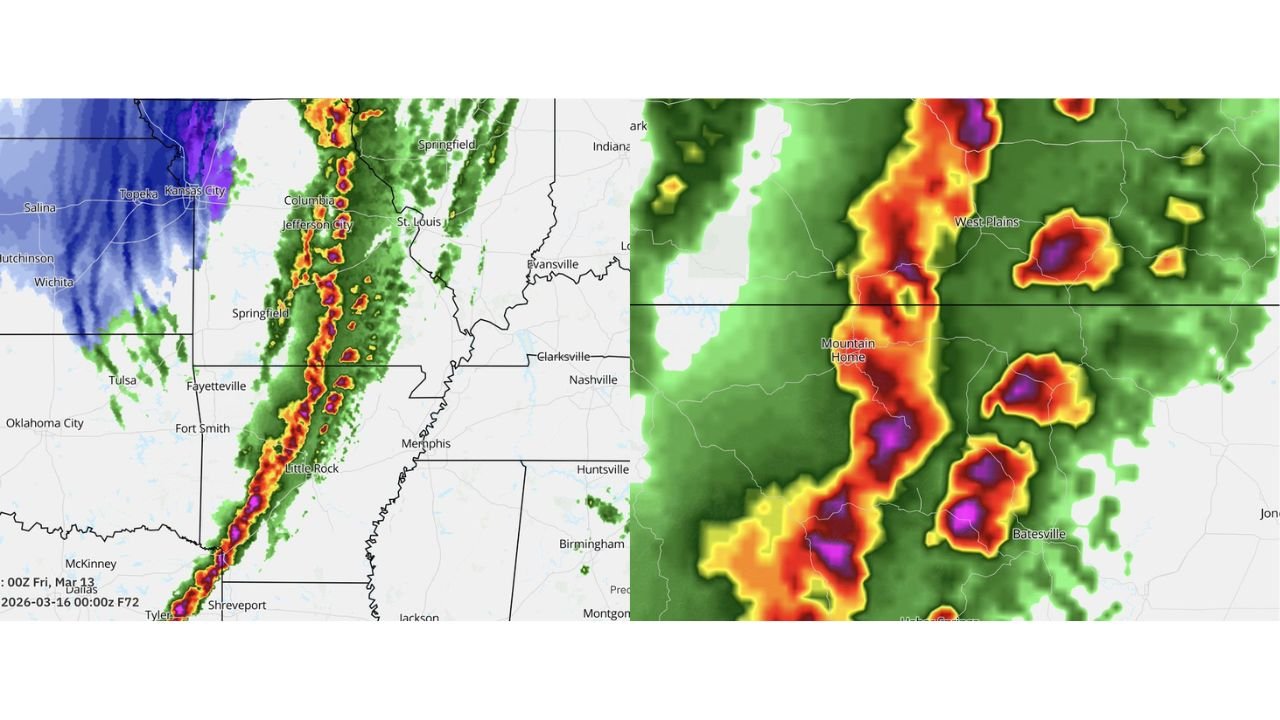
Storm Line Projected from Louisiana Through Arkansas into Missouri
Weather simulation imagery shows a long line of intense thunderstorms extending northward through the central United States. The projected storm corridor stretches from:
- Shreveport, Louisiana
- Little Rock, Arkansas
- Springfield and Jefferson City, Missouri
- Toward St. Louis, Missouri
The line of storms appears well-organized in the model output, suggesting the potential for a large band of severe thunderstorms moving rapidly across the region.
These types of storm systems often produce widespread wind damage, especially when the storms consolidate into a solid squall line.
Discrete Supercells Could Form Ahead of the Main Line
One key feature meteorologists are watching is the potential for discrete thunderstorms to develop ahead of the main squall line, particularly across north-central Arkansas.
Model output shows several isolated storm cells near areas including:
- Mountain Home, Arkansas
- West Plains, Missouri
- Batesville, Arkansas
If these isolated storms form in advance of the main line, they could briefly organize into supercells, which are capable of producing tornadoes before the squall line overtakes them.
Forecasters emphasize that this scenario is still based on raw model guidance and not a finalized forecast, but it is an important signal being monitored closely.
Little Rock and Memphis in the Potential Impact Zone
The main storm line appears likely to track across central Arkansas, placing cities such as Little Rock directly in the path of the developing system.
As the storms move northeast, the line may continue toward Memphis, Tennessee, where conditions could support additional severe thunderstorms.
Strong winds, heavy rainfall, and occasional tornado spin-ups are all possible with squall lines of this type.
Missouri Storm Threat Could Extend Toward St. Louis
As the system continues northward, severe weather potential may extend across southern and central Missouri, including areas near:
- Springfield
- Columbia
- Jefferson City
- St. Louis
Storms moving through Missouri could maintain strong wind fields capable of producing damaging gusts and intense rainfall.
The severity of storms farther north will depend on how the atmosphere evolves ahead of the line.
Why QLCS Storm Systems Can Be Dangerous
QLCS storm systems are known for their ability to produce fast-moving severe weather outbreaks.
Unlike isolated supercells that develop slowly, squall lines can move quickly across multiple states and bring widespread impacts.
These systems often produce:
- Damaging straight-line winds
- Embedded tornadoes
- Intense lightning
- Heavy rainfall
Tornadoes within squall lines can form rapidly and with little warning, making them particularly dangerous for communities in the path of the storms.
Forecast Still Developing
Meteorologists stress that the simulation shown is raw model output from a developing forecast scenario, meaning the exact timing and placement of storms could still change.
However, the data provides an early indication that the Arkansas–Missouri–Tennessee corridor could see active severe weather conditions if the system evolves as projected.
Residents in the region are encouraged to stay aware of weather updates as the forecast becomes clearer in the coming days.
Stay with WaldronNews for continuing coverage and updates as meteorologists track this developing severe weather threat across Arkansas, Missouri, and Tennessee.