
Arkansas, Missouri and Western Tennessee Face Tornado Risk as Surface Low Sets Up Over Mid-South With Strong 0–3km CAPE
ARKANSAS — A developing surface low positioned over the Mid-South is raising concerns for tornado potential this afternoon, as forecast data shows strong low-level instability and favorable vorticity across parts of eastern Arkansas, southeast Missouri, and western Tennessee.
New high-resolution model guidance suggests that while mid-level temperatures could limit widespread convection, the setup may still support quick-spin, low-topped tornadoes if storms manage to develop near the surface low.
Surface Low Positioned Over the Mid-South
Early analysis shows the surface low organizing near the Arkansas–Missouri region, placing much of eastern Arkansas, the Missouri Bootheel, and western Tennessee in a zone of enhanced spin and lift.
With the low tracking close to this corridor, localized forcing could help overcome mid-level warmth that might otherwise suppress deeper storms.
Forecasters note that this positioning keeps the highest risk near:
- Eastern Arkansas
- Southeast Missouri
- Western Tennessee
- Portions of northern Mississippi
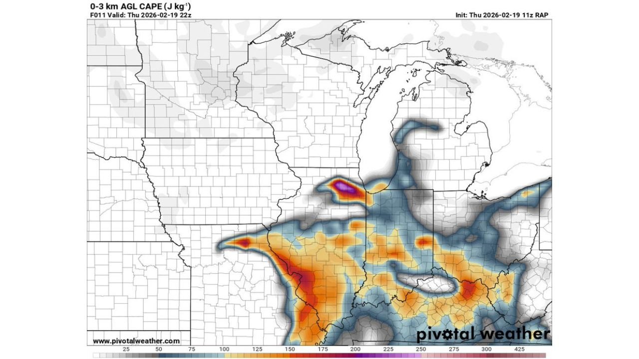
Strong 0–3km CAPE Signals Low-Level Tornado Potential
The 0–3 km AGL CAPE map highlights a pronounced corridor of instability stretching from eastern Arkansas into western Tennessee, with pockets exceeding 200–300 J/kg in localized zones.
This low-level CAPE is particularly important because:
- It enhances stretching potential in the lowest levels of the atmosphere.
- It increases the chance for tornado development even without classic supercells.
- It supports rapid spin-ups along boundaries or near the surface low.
A concentrated bullseye of stronger low-level instability appears near the Arkansas–Missouri border region, signaling an area to watch closely through the afternoon hours.
Sounding Data: Warm Mid-Levels but Favorable Shear
RAP forecast soundings near 39.97°N, 92.39°W indicate:
- Surface temperatures around the low 60s.
- Steep low-level lapse rates.
- Strong wind shear through the lower atmosphere.
- A critical angle near 54 degrees, supportive of rotating storms.
While mid-level warmth may cap more robust convection, forecasters emphasize that 3CAPE and vorticity are sufficient to produce a tornado without a classic supercell structure.
Storm-relative helicity and effective shear values remain supportive of rotating updrafts if storms initiate.
Marginal Supercell Signal but Tornado Risk Remains
SARS sounding analog guidance does not show strong classic supercell matches, and the overall severe hazard type is labeled as marginal severe (MRGL SVR).
However, the concern centers less on long-lived supercells and more on:
- Brief, low-topped rotating storms.
- Line-embedded spin-ups.
- Tornadoes forming near the surface low center.
In setups like this, storms do not need to be tall or intense to produce a quick tornado.
Areas Most at Risk This Afternoon
Based on current projections, the greatest tornado potential appears centered across:
- Eastern Arkansas
- Missouri Bootheel
- Western Tennessee
- Possibly extending into northern Mississippi
Residents in these regions should remain alert through the late afternoon and early evening as any storm that develops near the surface low could rotate quickly.
Bottom Line
Despite concerns about mid-level warming limiting widespread severe storms, the placement of the surface low over the Mid-South combined with strong low-level instability and favorable shear creates a localized tornado risk this afternoon.
Even without a classic supercell environment, the ingredients are present for quick-forming tornadoes, particularly in eastern Arkansas, southeast Missouri, and western Tennessee.
WaldronNews.com will continue monitoring updates as storms begin to initiate and as new data refines the afternoon outlook.