
Arkansas, Missouri, Illinois and Indiana Face Overnight Severe Storm Threat Sunday Night as 70+ mph Winds and Possible Tornadoes Sweep Midwest
ARKANSAS — A potentially dangerous overnight severe weather event is expected to develop late Sunday as a powerful squall line moves from Arkansas through Missouri, Illinois and into Indiana, bringing the threat of damaging winds exceeding 70 mph and possible embedded tornadoes.
Meteorologists warn that the storm system could sweep through parts of the Midwest overnight while many residents are sleeping, increasing the potential danger from rapidly developing severe storms.
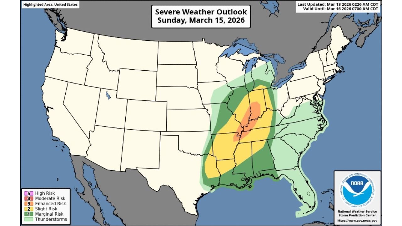
The Storm Prediction Center (SPC) has already placed a large corridor from the Mid-South into the Midwest under an Enhanced Risk (Level 3 of 5) for severe weather on Sunday.
Severe Storm Corridor Extends From Arkansas Into Indiana
Forecast models show the most intense storms forming along a strong cold front moving across the central United States.
The severe weather corridor stretches from:
- Arkansas
- Missouri
- Illinois
- Indiana
- Parts of Kentucky and Tennessee
Within this zone, the highest concentration of severe storms is expected across eastern Arkansas, southeastern Missouri, southern Illinois and western Indiana, where atmospheric conditions appear most favorable for strong storm development.
Cities potentially impacted along the storm track include:
- Little Rock, Arkansas
- Jonesboro, Arkansas
- St. Louis, Missouri
- Springfield, Illinois
- Evansville, Indiana
- Indianapolis, Indiana
Powerful Squall Line Expected to Develop
Weather models indicate that storms will likely organize into a long squall line, a type of thunderstorm structure capable of producing widespread damaging winds.
As the cold front pushes eastward, thunderstorms are expected to merge into a continuous line that could stretch hundreds of miles from north to south.
These squall lines often move quickly and can produce wind gusts exceeding 70 miles per hour, capable of causing:
- Widespread tree damage
- Power outages
- Structural damage to buildings
- Dangerous travel conditions
Because these systems move rapidly, the worst weather can arrive quickly after warnings are issued.
Embedded Tornadoes Also Possible
Although damaging winds are expected to be the primary threat, meteorologists say embedded tornadoes may develop within the storm line.
These tornadoes often form quickly within rotating segments of the squall line and may be difficult to detect visually, especially during nighttime events.
Areas most vulnerable to tornado development are typically located along the central portion of the storm line, where wind shear and atmospheric instability are strongest.
Overnight Timing Raises Safety Concerns
One of the biggest concerns surrounding Sunday night’s storm system is its overnight timing.
The most intense storms are expected to move through parts of Arkansas and Missouri late Sunday evening, before pushing into Illinois and Indiana during the overnight hours and early Monday morning.
Nighttime severe weather events can be particularly dangerous because many people are asleep and may not receive warnings in time.
Meteorologists stress the importance of having multiple ways to receive weather alerts overnight, including:
- Wireless emergency alerts on smartphones
- NOAA Weather Radios
- Local weather apps and broadcast alerts
Why This Storm System Could Be Significant
The developing severe weather outbreak is tied to a strong low-pressure system forming across the central United States, which will pull warm, humid air northward from the Gulf of Mexico.
At the same time, powerful winds in the upper atmosphere will provide the energy needed for storms to organize and strengthen.
This combination of ingredients often leads to widespread severe weather outbreaks across the Midwest and Mid-South during early spring.
Residents Urged to Prepare Before Storms Arrive
Emergency officials recommend that residents across Arkansas, Missouri, Illinois and Indiana review severe weather safety plans before Sunday night.
Preparation steps include:
- Charging phones and emergency devices
- Identifying safe shelter areas in homes
- Monitoring weather forecasts through the weekend
- Ensuring weather alerts are enabled overnight
Officials emphasize that strong wind events associated with squall lines can cause damage across large regions in a short amount of time.
Forecast Still Being Refined
Meteorologists will continue monitoring new forecast data over the next several days to determine exactly where the strongest storms will develop.
However, current projections indicate that a widespread damaging wind event is possible from Arkansas into Indiana late Sunday night into early Monday morning.
Stay with WaldronNews for continued updates as forecasters track this developing severe weather threat across the Midwest and Mid-South.