
Arkansas, Oklahoma, Kansas, and Missouri Sit Near Powerful Storm Core as SPC Hand Analysis Reveals Deepening Low and High-End Severe Setup
ARKANSAS — A rare, hand-drawn surface analysis from the Storm Prediction Center is offering a striking look at a powerful and highly organized storm system unfolding across the central United States, with Arkansas and surrounding states positioned dangerously close to the heart of the setup.
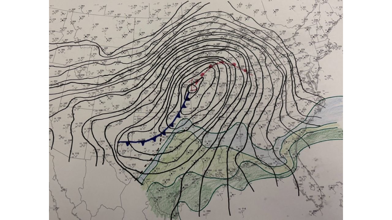
Unlike automated model graphics, this hand analysis highlights the real-time structure of the atmosphere — and what it shows is a deepening low-pressure system centered over the Plains with tightly packed pressure lines signaling an intense and dynamic environment.
A Deep Low Anchored Over the Central Plains
The map clearly shows a well-defined low-pressure center over parts of Kansas/Oklahoma, with pressure values tightly wrapped around the system — a classic sign of strengthening storm dynamics.
From this center:
- A cold front extends southward into Texas
- A warm front arcs eastward toward Missouri and Illinois
- Strong pressure gradients surround the system, indicating powerful winds and rapid atmospheric movement
This setup is textbook for severe weather — especially when combined with moisture and instability already in place across the South.
Arkansas Positioned in the Dangerous “Warm Sector”
Arkansas sits squarely in what meteorologists call the warm sector — the zone between the warm front and cold front where conditions are most favorable for severe storms.
Key characteristics of this region include:
- Warm, moist air surging north from the Gulf of Mexico
- Strong wind shear due to changing wind speeds and directions with height
- Increasing instability as daytime heating builds
This combination creates a volatile environment capable of producing:
- Tornadoes
- Damaging straight-line winds
- Large hail
Strong Lift and Wind Energy Driving Storm Development
The tightly packed lines on the map — representing pressure and wind flow — indicate strong atmospheric lift and significant wind energy.
This means storms that form in this environment will have:
- Rapid upward motion (fueling thunderstorm growth)
- Organized rotation potential
- Ability to sustain themselves over longer distances
Additionally, the positioning of the low suggests that storms will track northeastward, impacting areas from:
- Eastern Oklahoma into Arkansas
- Missouri and Illinois
- Possibly extending toward the Mid-Mississippi Valley and beyond
Why This Setup Is Particularly Concerning
What makes this situation stand out is the structure and balance of the system.
Everything is aligned:
- A strong surface low
- Well-defined frontal boundaries
- Rich moisture supply from the Gulf
- Strong upper-level support
This alignment increases the risk of organized severe weather rather than isolated storms.
In setups like this, storms can evolve into:
- Supercells capable of producing tornadoes
- Squall lines with widespread damaging winds
- Clusters of storms that repeatedly track over the same areas
Hand Analysis Highlights Real-Time Reality
Forecasters emphasized that even in 2026, hand-drawn surface analysis remains one of the most reliable ways to interpret complex storm environments.
This map captures subtle but critical details:
- Exact placement of fronts
- Pressure gradients that models may smooth out
- Real-world observations feeding into the forecast
It provides a clearer picture of where the true storm threats are likely to focus — and right now, that focus includes Arkansas and nearby states.
What to Expect Through the Day
As the system continues to evolve:
- Storms are expected to develop along and ahead of the cold front
- Discrete supercells may form in the warm sector, especially across Arkansas
- A transition to a more organized line of storms is possible later
Timing will be critical, as peak heating could further intensify storm strength.
Areas to Watch Closely
Based on the current setup, the highest concern includes:
- Western and central Arkansas
- Eastern Oklahoma
- Southern Missouri
- Parts of northern Texas and Kansas
These areas are closest to the core dynamics of the system and most likely to see the strongest storms.
Bottom Line
This is a classic high-impact severe weather setup, with Arkansas positioned in a particularly vulnerable zone.
- A deep low-pressure system is intensifying over the Plains
- Strong fronts and wind fields are organizing the atmosphere
- Conditions are favorable for significant severe weather
Residents should remain alert, monitor warnings closely, and be prepared to act quickly if severe weather develops.
Stay with WaldronNews.com for continued updates as this powerful storm system evolves across the region.