
Arkansas, Oklahoma, Missouri and Kansas Could Face Unusual Severe Storm Setup as Powerful Jet Stream and Extreme Instability Build Across the Midwest
UNITED STATES — Meteorologists are closely watching a rare atmospheric setup developing across the central United States, where an unusual combination of jet stream dynamics and increasing instability could create conditions favorable for strong thunderstorms across Arkansas, Oklahoma, Missouri, Kansas and nearby Midwest states.
While forecasters note that the pattern is not the typical configuration usually associated with widespread severe weather, current model trends suggest the environment could still support powerful storms as atmospheric ingredients begin to align.
Unusual Synoptic Pattern Taking Shape Over the Central U.S.
Weather models indicate that a cutoff trough ejecting from the southern United States will begin interacting with a northern stream disturbance, allowing the two systems to partially couple or “phase” together.
This interaction could create a broad west-to-east jet stream flow across the northern portion of the warm sector, stretching from the central Plains toward the Midwest.
The area near the stationary boundary separating warm and cooler air masses could become the most favorable region for storm development, especially across portions of:
- Arkansas
- Oklahoma
- Missouri
- Kansas
- Illinois
- Indiana
Meteorologists say these zones may experience the strongest atmospheric forcing as the upper-level energy moves through the region.
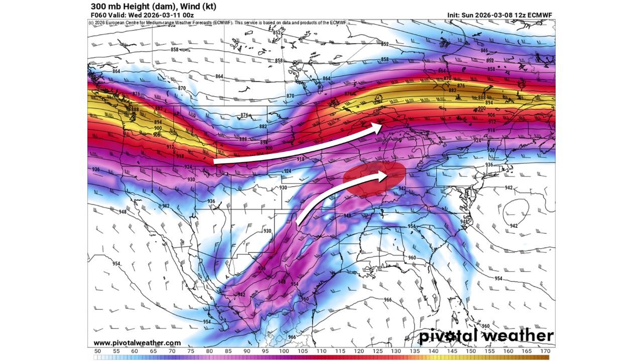
Powerful Jet Stream Could Enhance Storm Organization
Forecast charts of the 500 mb and 300 mb wind fields show an intense jet stream corridor moving across the central United States, with strong winds extending from the Plains toward the Midwest and Great Lakes.
The presence of these powerful winds in the upper atmosphere is important because it can help storms organize and maintain strength once thunderstorms begin to develop.
A second jet streak emerging from Texas into the lower Mississippi Valley may further enhance the environment by transporting additional energy into the storm system.
When these features interact, they can significantly increase the vertical wind shear, which is a key ingredient for organized thunderstorms and potential severe weather.
Increasing Instability Could Fuel Strong Thunderstorms
At the same time, atmospheric models are showing increasing moisture and instability across the warm sector, particularly during the afternoon and evening hours.
Forecast guidance from models such as RRFS and UKMET suggests some areas could see Convective Available Potential Energy (CAPE) exceeding 3000, which represents a highly unstable atmosphere capable of supporting intense thunderstorms.
This increasing instability appears to be tied to:
- Stronger surface heating
- Increasing low-level moisture
- Less widespread early-day storm activity
If early storms remain limited during the morning hours, the atmosphere will have more time to destabilize before the main storm development period.
Midwest and Central States Could See the Greatest Risk
The corridor most favorable for strong storms currently appears to stretch from the southern Plains into the Midwest, particularly across parts of:
- Arkansas
- Missouri
- Oklahoma
- Kansas
- Illinois
- Indiana
These states lie near the northern edge of the warm sector where the jet stream dynamics and instability may overlap most effectively.
However, meteorologists caution that some weather models may be overly aggressive with instability forecasts, meaning conditions could end up slightly less extreme than current projections.
Forecast Still Evolving
Forecasters stress that the overall setup is still developing and could change over the coming days as models continue to refine the interaction between the northern and southern jet stream systems.
Even though the atmospheric configuration is somewhat unusual for severe weather, the combination of strong jet stream support, increasing moisture, and rising instability could still produce a period of active thunderstorms across the central United States.
Residents across Arkansas, Oklahoma, Missouri and Kansas are encouraged to stay aware of forecast updates as meteorologists monitor the evolving storm environment.
Stay with WaldronNews for the latest updates as forecasters track this developing severe weather setup across the Plains and Midwest.