
Arkansas, Tennessee, Mississippi and Kentucky Under Enhanced Severe Storm Threat Sunday as 75+ MPH Winds and Tornadoes Become Increasingly Likely
UNITED STATES — A widespread and potentially dangerous severe weather outbreak is expected to unfold across the Mid-South and parts of the Deep South on Sunday, March 15, with forecasters warning that damaging wind gusts exceeding 75 mph and several tornadoes may develop across states including Arkansas, Tennessee, Mississippi, Kentucky and Alabama.
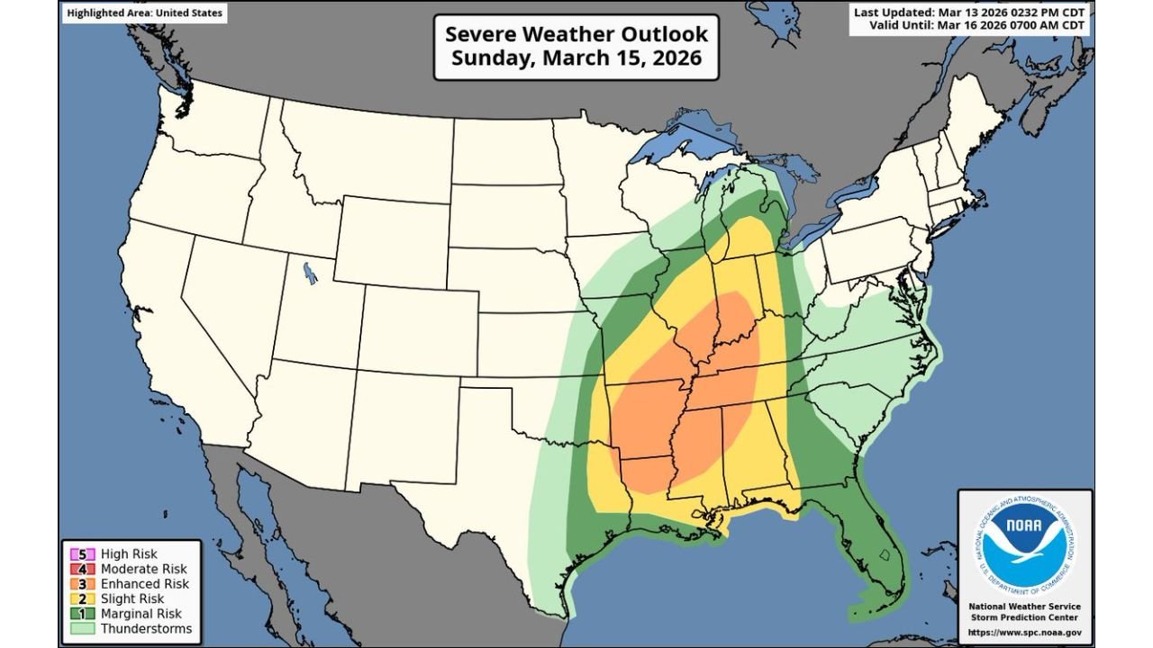
The Storm Prediction Center (SPC) has significantly expanded its Level 3 “Enhanced Risk” zone, now covering a large portion of the Mid-South as confidence grows that a powerful storm system will trigger widespread thunderstorms capable of producing severe weather.
Meteorologists say the developing setup could support a large and organized line of storms moving across the Mississippi and Ohio River valleys during the day Sunday and into Sunday night.
Enhanced Risk Expanded Across the Mid-South
The updated outlook places a large region of the central and southern United States under a heightened severe weather threat.
States within the expanded Enhanced Risk area include:
- Arkansas
- Tennessee
- Mississippi
- Kentucky
- Alabama
- Portions of Missouri, Illinois, and Louisiana
Cities potentially affected by the strongest storms include Little Rock, Memphis, Nashville, Jackson, Birmingham, and Louisville.
This level of risk typically indicates numerous severe storms are possible, with some capable of producing significant damage.
Dangerous Wind Gusts Could Exceed 75 MPH
The primary threat from Sunday’s storms appears to be widespread damaging straight-line winds, especially as thunderstorms organize into a fast-moving squall line.
Forecasters say many locations could see wind gusts exceeding 75 mph, strong enough to:
- Down trees and power lines
- Cause scattered power outages
- Damage roofs and structures
These storms may move quickly, which could allow damaging winds to impact a large area in a short amount of time.
Tornado Risk Also Increasing
Along with damaging winds, forecasters warn that several tornadoes may develop within the storm system, particularly if individual rotating storms form ahead of the main squall line.
Meteorologists note that embedded tornadoes within the squall line are likely, but there is also concern that isolated supercells could develop in advance of the main storms.
If that occurs, the tornado threat could become more significant.
The possibility exists for a few strong tornadoes, especially in areas where storms can remain isolated long enough to strengthen.
45 Percent Severe Weather Zone Highlights Mississippi and Ohio Valley
Forecast maps also show a 45 percent probability zone for severe weather centered around portions of the Mississippi and Ohio River valleys.
This probability level signals a very active severe weather environment, where storms capable of producing damaging winds, tornadoes, and large hail could affect a large region.
Communities across western Kentucky, northern Mississippi, western Tennessee, southern Illinois, and eastern Arkansas appear to be within this higher-risk corridor.
Storms Expected to Intensify Sunday Afternoon and Evening
Current forecast timing suggests the severe weather threat will begin late Sunday afternoon and continue through Sunday night as a powerful cold front moves eastward across the region.
Warm, humid air moving north from the Gulf of Mexico will combine with strong upper-level winds and atmospheric instability, creating favorable conditions for severe thunderstorms.
This type of setup is commonly associated with spring severe weather outbreaks across the Mid-South.
Residents Urged to Monitor Weather Conditions Closely
With the storm system still developing, meteorologists emphasize that exact storm tracks and the highest-risk areas may shift slightly over the next 24–48 hours.
However, the growing confidence in widespread severe storms means residents across the Mid-South should begin preparing now.
Officials recommend that people:
- Stay alert to weather warnings
- Have multiple ways to receive emergency alerts
- Know where to take shelter if tornado warnings are issued
Because some storms could occur after sunset, having reliable overnight warning methods will be especially important.
Stay with WaldronNews for continuing coverage as meteorologists track this developing severe weather threat across Arkansas, Tennessee, Mississippi, Kentucky and the broader Mid-South region.