
Arkansas, Texas, Oklahoma and the Central/Eastern U.S. Set for Significant Warm-Up March 6–15 Ahead of Potential Stratospheric Shift
UNITED STATES — A notable pattern change is taking shape across the Central and Eastern United States, with significantly warmer temperatures expected from March 6 through March 15, including across Arkansas and much of the Southern Plains.
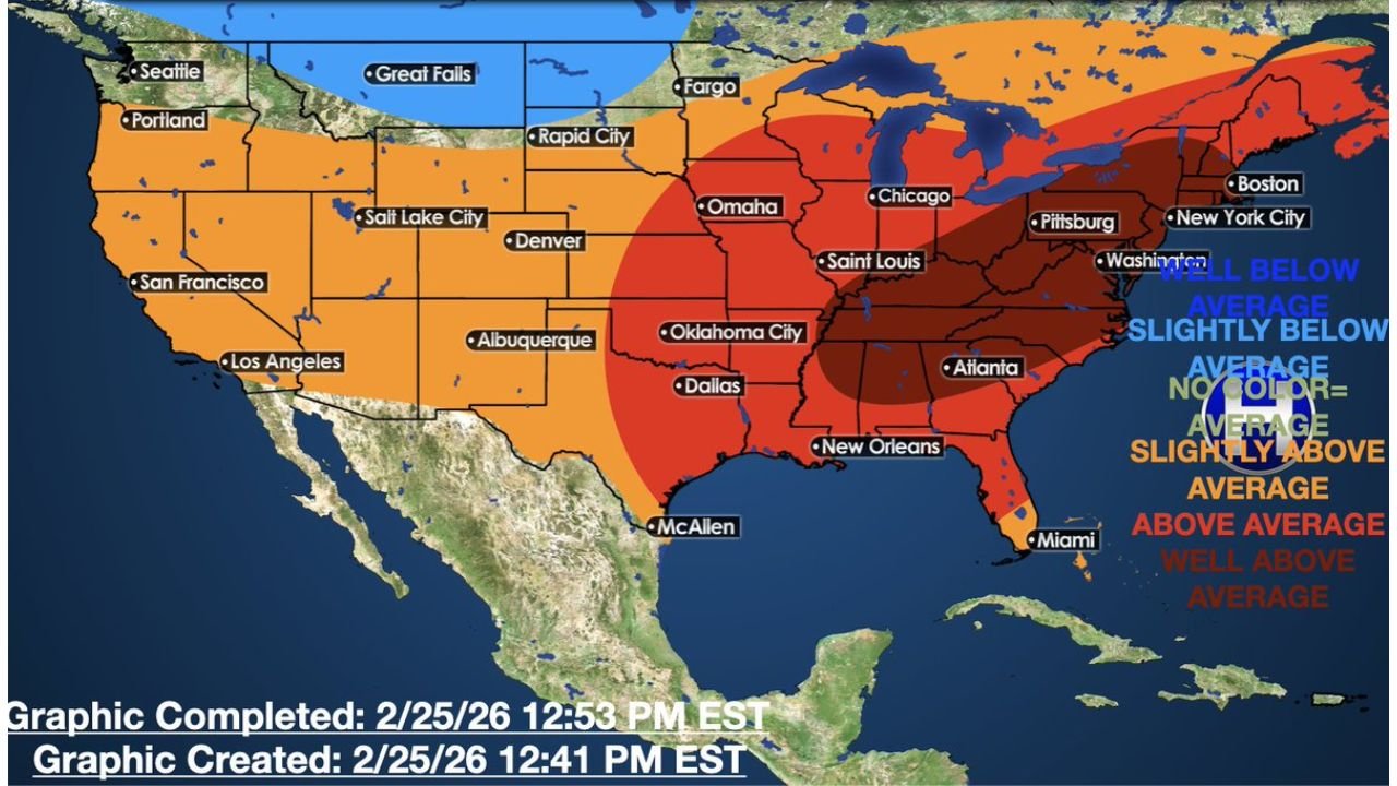
The latest temperature outlook map shows widespread above-average warmth stretching from Texas and Oklahoma through Arkansas, Louisiana, Mississippi, Missouri, Illinois, Indiana, Kentucky, Tennessee, Georgia, the Carolinas, and into the Mid-Atlantic and Northeast, including cities such as Chicago, St. Louis, Atlanta, Pittsburgh, Washington, D.C., New York City and Boston.
Arkansas and Surrounding States Trending Warmer Than Average
For Arkansas and nearby states, the outlook indicates:
- Above-average temperatures statewide
- Strongest warm anomalies centered from Texas through Arkansas into the Ohio Valley
- Continued warmth extending into the Southeast
Oklahoma City, Dallas, New Orleans, Atlanta and St. Louis are all positioned within the deeper red shading — signaling above-average to well above-average conditions during this period.
For Arkansas residents, this suggests a noticeable break from winter-like chill, with springlike afternoons becoming more common.
Central and Eastern U.S. Warming Trend Expands North
The warm signal broadens into:
- Missouri
- Illinois (including Chicago)
- Indiana
- Ohio
- Pennsylvania
- New York
- Massachusetts
Even portions of the Great Lakes region fall within above-average temperature shading, though slightly less intense than the Deep South and Lower Mississippi Valley.
Western U.S. More Mixed
While the Central and Eastern U.S. warms significantly, parts of the Pacific Northwest and Northern Rockies show cooler-than-average shading, including:
- Portions of Washington
- Northern Idaho
- Western Montana
Much of the Southwest and interior West trends slightly above average but not to the degree of the central corridor.
Why the Warm Pattern Is Developing
The outlook notes that these warmer periods are common just before or during potential stratospheric warming events (SSWE). While that upper-atmospheric shift remains a developing factor, near-term impacts favor a broad warm ridge across the eastern half of the country.
Patterns like this typically feature:
- Stronger southerly flow
- Increased Gulf moisture return
- Suppressed Arctic intrusions
That setup allows temperatures to climb well above early-March averages.
What It Means for Arkansas
For Arkansas specifically:
- Afternoon highs are likely to trend several degrees above normal
- A more springlike feel is expected during the March 6–15 window
- Warmer air could also support increased thunderstorm opportunities if storm systems develop
This shift could mark a meaningful transition toward early spring conditions after a winter dominated by colder stretches.
Bottom Line
From Texas and Oklahoma through Arkansas and into the Midwest, Southeast and Northeast, a broad warm-up is expected between March 6 and March 15.
Arkansas sits squarely within the above-average temperature zone, signaling a clear break from recent cold and a potential preview of spring across the region.
Stay with WaldronNews.com for continuing updates as this warming pattern develops and as forecasters monitor any larger atmospheric changes that could influence weather later in March.