
Austin Texas Needs Over 1 Foot of Rain in One Month to End Drought as National Centers for Environmental Information Data Shows 14 to 17 Inches Required East of the City
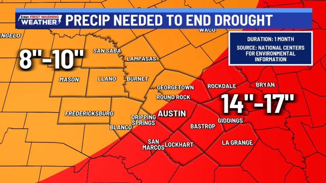
AUSTIN, TEXAS — The drought gripping Central Texas is far deeper than most residents may realize. According to the National Centers for Environmental Information (NCEI), it would take over 1 foot of rain in the next month alone to eliminate drought conditions across the Austin, Texas area — and communities to the east of the city face an even steeper deficit. A forecast graphic from KXAN First Warning Weather shows the staggering precipitation needed to end drought across the region: 8 to 10 inches across the western corridor and a jaw-dropping 14 to 17 inches across Austin and communities east toward Bryan, Rockdale, Giddings and La Grange — all within a single 30-day window.
These are hard numbers that put the severity of Central Texas’s drought crisis into stark perspective.
Cities and Counties That Need the Most Rain
The NCEI drought elimination precipitation map shows the following rainfall requirements across Central Texas over the next month:
Extreme Deficit Zone — 14 to 17 inches needed:
- Austin — city center directly in the 14 to 17 inch zone
- Round Rock and Georgetown — northern Austin suburbs facing the same massive deficit
- Dripping Springs and Blanco — Hill Country communities west of Austin
- Bastrop and Lockhart — east and southeast of Austin
- Giddings and La Grange — deep east deficit zone
- Rockdale — northeast of Austin in the highest-need corridor
- Bryan — eastern extent of the extreme deficit zone
- San Marcos — south of Austin also in the deep deficit
Severe Deficit Zone — 8 to 10 inches needed:
- Mason and Fredericksburg — western Hill Country
- Llano and Burnet — Highland Lakes corridor
- San Saba and Lampasas — north-central Texas communities
- Angelo area (western fringe) — lighter deficit but still significant
What These Numbers Mean for Central Texas
The drought elimination numbers from the National Centers for Environmental Information are not just statistics — they represent the scale of how far Austin and Central Texas has fallen below normal moisture levels. 14 to 17 inches of rainfall in a single month would be an extraordinary amount for any location in Texas — for context, Austin’s average annual rainfall is approximately 33 inches. Eliminating the current drought would require roughly half of a year’s worth of normal rainfall to fall in a single 30-day period.
This is not a drought that a few good thunderstorms will fix. The NCEI data makes clear that only a sustained, historically extreme rainfall event — the kind that occurs once in decades — could fully eliminate drought conditions across Austin, Round Rock, Georgetown, Bastrop and the surrounding Central Texas region within the next month.
Bryan and Rockdale to the northeast face similarly extreme deficits in the 14 to 17 inch range, while western communities like Fredericksburg, Mason and Llano — though still severely drought-stressed — require somewhat less at 8 to 10 inches to achieve full drought elimination.
Why Austin’s Drought Has Become So Severe
Central Texas has been locked in a persistent drought pattern driven by a combination of below-normal rainfall over multiple months and above-normal temperatures that have accelerated soil moisture depletion. The Highland Lakes — the chain of reservoirs on the Colorado River that supply water to Austin and surrounding communities — have seen significant drawdowns as a result.
The deep deficit east of Austin — where 14 to 17 inches would be needed — reflects both the extended dry period and the particular geography of the eastern Travis, Bastrop and Lee County corridors, where soils have been baked dry through consecutive months of below-normal precipitation and above-normal heat.
Multi-Day Pattern: Limited Relief in Sight
While Central Texas has seen some storm chances in recent weeks, the rainfall totals from these events have fallen far short of what would be needed to make a meaningful dent in the drought picture. Even a significant multi-inch rainfall event across Austin would only partially address the deficit — and the NCEI data makes clear that full drought elimination requires a level of rainfall that is simply not on any near-term forecast horizon.
Residents, water managers and agricultural producers across Austin, Round Rock, Bastrop, Georgetown and Bryan should plan for drought conditions to persist well into spring and potentially through summer 2026 without extraordinary rainfall.
What to Watch Next
Key details to monitor as the Central Texas drought continues:
- Highland Lakes water levels — tracking reservoir storage across the Colorado River system serving Austin
- Any significant rainfall events across Travis, Bastrop, Lee and Burleson counties — even partial drought relief would be meaningful
- Updated NCEI drought monitor — whether conditions worsen or hold steady through April
- Summer outlook — whether long-range models signal continued dry pattern for Central Texas
- Water restriction status in Austin and Round Rock — whether Stage 2 or higher restrictions are implemented if drought deepens
- Agricultural impact reports from Fredericksburg, Mason and Llano areas of the Hill Country
Residents across Austin, Round Rock, Georgetown, Bastrop, Lockhart, San Marcos, Bryan and Rockdale should monitor local water utility communications and prepare for the possibility of extended drought conditions across Central Texas well into 2026.
WaldronNews.com will continue tracking the Central Texas drought situation and provide updates on rainfall totals, reservoir levels and drought monitor classifications as conditions evolve.