
Back-to-Back Severe Weather Threat Targets Ohio Valley and Great Lakes February 18–19 as Missouri, Illinois, Indiana and Ohio Face Elevated Storm Risk
UNITED STATES — Medium-range guidance is signaling the potential for back-to-back severe weather events across the Ohio Valley and lower Great Lakes region on Wednesday and Thursday, February 18–19, 2026.
Forecast probability maps for Day 4 (Wednesday) and Day 5 (Thursday) show overlapping risk zones centered on portions of Missouri, Illinois, Indiana, Ohio, and Kentucky, with the highest probabilities currently focused across the mid-Mississippi Valley into the Ohio Valley.
While higher-resolution models are still pending, the early signals are strong enough to warrant attention across multiple states.
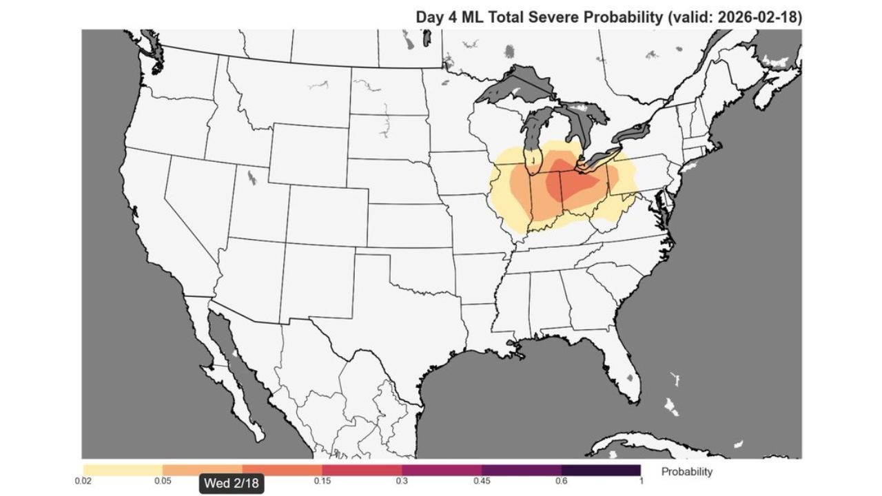
Day 4 (Wednesday, February 18): Core Risk Over Illinois, Indiana and Western Ohio
The Day 4 severe probability map highlights an area stretching from:
- Eastern Missouri
- Central and Southern Illinois
- Central Indiana
- Western Ohio
- Northern Kentucky
The darker shading on the map indicates a more concentrated severe probability zone centered roughly from St. Louis to Indianapolis and toward western Ohio.
Major cities near or within this highlighted corridor include:
- St. Louis, Missouri
- Springfield and Peoria, Illinois
- Indianapolis, Indiana
- Cincinnati, Ohio
- Louisville, Kentucky
This corridor is frequently active during early-season severe setups when Gulf moisture surges northward ahead of a strong mid-latitude system.
Day 5 (Thursday, February 19): Risk Shifts Slightly South and East
By Thursday, the severe probability area shifts somewhat southeast while still covering much of the Ohio Valley.
Highlighted areas include:
- Southern Illinois
- Southern and Central Indiana
- Western and Central Kentucky
- Portions of Ohio
- Northern Tennessee
Cities in or near the Thursday risk zone include:
- Evansville, Indiana
- Louisville, Kentucky
- Lexington, Kentucky
- Cincinnati, Ohio
- Columbus, Ohio
The overlapping risk across both days suggests the possibility of two separate storm systems or waves moving through the same general region.
Why Back-to-Back Events Matter
When severe weather threats occur on consecutive days:
- Soil conditions may already be saturated from earlier rainfall.
- Infrastructure and power grids can face compounded stress.
- Recovery time between systems becomes limited.
Additionally, early-season severe weather can catch communities off guard compared to peak spring months.
Still Waiting on High-Resolution Guidance
Forecasters caution that:
- Hi-resolution models won’t fully sample this setup until late Monday night or Tuesday.
- Exact storm modes (discrete supercells vs. squall lines) remain uncertain.
- The highest probability corridor could still shift north or south.
However, medium-range agreement between guidance sources is increasing confidence that at least one organized severe weather event is likely mid-week.
States That Should Closely Monitor Updates
Residents across the following states should pay attention over the next 48 hours:
- Missouri
- Illinois
- Indiana
- Ohio
- Kentucky
- Northern Tennessee
Even small track adjustments could bring the risk zone into adjacent areas of Michigan or West Virginia.
What Happens Next
Over the coming days:
- Storm timing will become clearer.
- Instability and wind shear parameters will be refined.
- Official outlooks may introduce categorical risk levels (Marginal, Slight, Enhanced, etc.).
For now, the message is simple: the Ohio Valley region faces a credible risk for severe weather on both Wednesday and Thursday.
WaldronNews.com will continue monitoring model trends and provide updated breakdowns as high-resolution data becomes available.