
Blizzard Warning Issued for New York City, Long Island and Coastal New Jersey as Nor’easter Threatens 12–18+ Inches and Dangerous Coastal Flooding
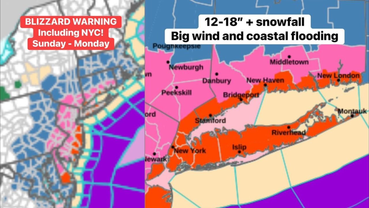
NEW YORK CITY AND TRI-STATE AREA — A Blizzard Warning has been issued for New York City, Long Island, and coastal sections of New Jersey and Delaware as a powerful nor’easter rapidly strengthens offshore Sunday into Monday. Forecasters warn that this system could deliver 12 to 18 inches of snow — or more in isolated spots — along with strong winds and coastal flooding.
The warning covers New York City, Stamford, Bridgeport, New Haven, Long Island including Islip and Riverhead, and coastal communities stretching south through New Jersey and Delaware.
12–18+ Inches Possible in Core Impact Zone
Current projections place the heaviest snowfall axis directly along the coast. Areas in and around:
- New York City
- Stamford and Bridgeport, Connecticut
- New Haven and New London
- Long Island from western Nassau County to Montauk
- Coastal New Jersey communities
could see 12 to 18 inches or more before the storm pulls away.
Localized totals could exceed that range if mesoscale banding sets up and stalls over the same areas for several hours.
Big Winds Raise Blizzard and Flooding Concerns
In addition to heavy snowfall, strong winds are expected to develop as the storm “bombs out” offshore. That rapid intensification will increase pressure gradients, driving:
- Gusts potentially exceeding 40–50 mph near the coast
- Blowing and drifting snow
- Near-zero visibility during peak snowfall
- Elevated risk for scattered power outages
Blizzard conditions require sustained winds of 35 mph or greater combined with falling or blowing snow that reduces visibility to a quarter mile or less. Those conditions are now considered possible across coastal sections, including NYC and Long Island.
At the same time, onshore flow raises the threat of coastal flooding, particularly during high tide cycles. Shoreline communities in Long Island, coastal Connecticut, and the New Jersey coast should prepare for water level rises and potential roadway flooding.
Inland Gradient Still Sharp
While coastal communities face the brunt of the storm, snowfall totals are expected to taper inland. Areas farther north and west from the immediate shoreline may still receive significant snow, but the most intense impacts are currently forecast along and just inland from the coast.
A slight shift east or west could still adjust the highest snowfall corridor. However, confidence is increasing that the I-95 coastal corridor will experience major impacts.
Travel and Safety Concerns Sunday Into Monday
Heavy snow combined with strong winds could create dangerous travel conditions late Sunday into Monday morning. Roadways may become snow-covered quickly, and blowing snow could severely limit visibility.
Residents in New York City, Long Island, coastal Connecticut, coastal New Jersey, and Delaware are urged to:
- Avoid unnecessary travel during peak storm hours
- Prepare for potential power disruptions
- Monitor official updates from local emergency management
Bottom Line
This is shaping up to be a significant coastal winter storm with the potential for blizzard conditions, heavy snowfall, and coastal flooding. Snow totals of 12–18 inches or more are possible in the hardest-hit areas, especially across New York City and Long Island.
Stay with Waldronnews.com for continuing updates as the nor’easter strengthens and moves through the region.