
“Blizzardsaurus” Takes Aim at East Coast: Major Snowstorm Threat From Virginia and Maryland to New York and New England Sunday Into Monday
EASTERN UNITED STATES — A powerful storm system now crossing the Southwest is forecast to intensify as it reaches the East Coast Sunday, with forecasters branding the setup “Blizzardsaurus” due to its potential size and impact. The system is expected to strengthen Sunday into Monday, bringing a high probability of a major snowstorm to parts of the Mid-Atlantic and Northeast.
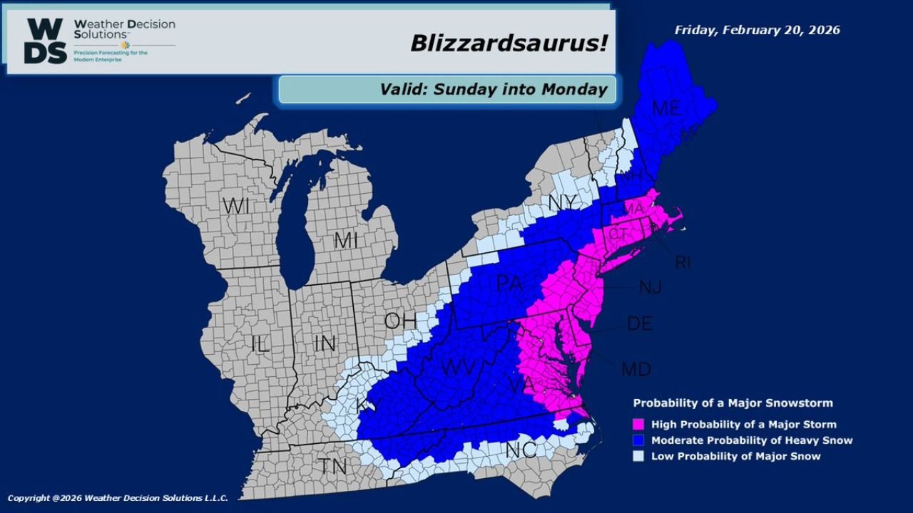
The latest probability map valid Sunday into Monday shows a broad corridor of moderate to high snowstorm risk stretching from the central Appalachians through the I-95 corridor and into New England.
Highest Probability Zone: Virginia to Southern New England
The most concerning zone — marked in bright pink on the forecast map — indicates a high probability of a major snowstorm across:
- Eastern Virginia
- Maryland
- Delaware
- New Jersey
- Eastern Pennsylvania
- New York City and surrounding areas
- Connecticut
- Rhode Island
- Eastern Massachusetts
This corridor includes several densely populated metro areas where heavy snowfall rates and potential strong winds could combine to create hazardous travel conditions late Sunday through Monday.
Moderate Heavy Snow Risk: Appalachians to Interior Northeast
Surrounding the highest-risk corridor is a broad area shaded in dark blue, signaling a moderate probability of heavy snow. This region spans:
- West Virginia
- Western and central Pennsylvania
- Upstate New York
- New Hampshire
- Maine
- Parts of Kentucky and North Carolina
These areas may see significant snowfall, though the probability of extreme impacts appears slightly lower than along the coastal Mid-Atlantic and southern New England.
Lower Probability Fringe Areas
Lighter shading on the map indicates a lower probability of major snow impacts extending into portions of:
- Ohio
- Indiana
- Tennessee
- Interior sections of North Carolina
- Western sections of New York and New England
In these fringe zones, snowfall amounts and impacts will depend heavily on the exact track and strength of the developing coastal low.
Storm Evolution: Southwest to Nor’easter?
The system is currently moving across the Southwest before ejecting eastward. As it interacts with Atlantic moisture and coastal temperature contrasts, forecasters expect rapid intensification along the Eastern Seaboard.
If strengthening occurs close enough to the coastline, the storm could take on characteristics of a major Nor’easter — including:
- Heavy, wind-driven snow
- Rapid snowfall accumulation
- Reduced visibility
- Potential coastal impacts
The heaviest snow band placement will ultimately determine which metro areas see the most significant totals.
Sunday Into Monday: Critical Window
The forecast window highlights Sunday into Monday as the period of greatest impact. Travel disruptions are possible across major highways from Interstate 95 in Virginia and Maryland northward through New York and into Massachusetts.
With the storm still evolving, small shifts in track could shift the highest snow zone north or south by dozens of miles — dramatically changing totals in cities like Washington, D.C., Philadelphia, New York, and Boston.
What Residents Should Watch
Over the next 24–36 hours, updated model runs will clarify:
- Exact storm track offshore
- Rain/snow line placement in southern zones
- Development of intense snow bands
- Wind strength and coastal pressure gradient
Residents across the Mid-Atlantic and Northeast should monitor forecast updates closely and prepare for the possibility of significant snowfall and hazardous travel late weekend into early next week.
Stay with Waldronnews.com for the latest developments as “Blizzardsaurus” approaches the East Coast.